Grosse Point (Knight Point), PQ 
Select a photograph to view a photo gallery
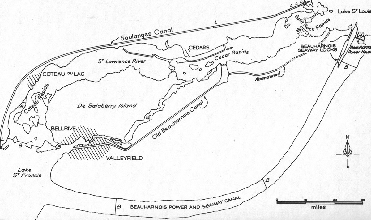
Photo Gallery

Photo Gallery
Photo Gallery
Shortly after the unification of Lower and Upper Canada in 1841, the Board of Public Works decided to build the twenty-four-kilometre-long Beauharnois Canal along the south shore of the river to bypass the three sets of rapids. This canal was finished in 1845 and served for over fifty years until a canal with a greater depth was needed. As this could most easily be accomplished by a canal along the north shore of the river, work on Soulanges Canal, which is twenty-three kilometres long, has a depth of 4.3 metres, and runs between Pointe-des-Cascades on Lake St. Louis and Coteau-Landing on Lake St. Francis, began in 1892 and was completed in 1899 at a cost of $4,251,158.
In 1845, a lighthouse was placed on a pier at the head of the channel leading to Beauharnois Canal from Lake St. Francis and another lighthouse on a pier leading from Lake St. Louis to the canal. The lighthouse to mark the upper entrance was located north of Grosse Point and was known as Grosse Point Lighthouse. By 1850, three towers had been built on or just off Knight Point, which was located 1,200 metres southwest of the upper canal entrance, to provide range lights for accessing the canal. These three lights were known as 1st Range Light, 2nd Range Light, and 3rd Range Light.
Mariners would use Grosse Point Light and 3rd Range Light, located 311 metres to the east, to form a range line for proceeding between these lights and the canal entrance at Valleyfield. Grosse Point Lighthouse was a square, wooden tower, thirty feet tall, that exhibited its light at a height of thirty-eight feet above the river. 3rd Range Light was a square, wooden tower, twelve feet tall, that exhibited its light at a height of twelve feet above the river.
Mariners used 1st Range Light and 2nd Range Light in alignment to know when to turn westward from the axis of Beauharnois Canal. 1st Range Light was a square, wooden tower, twelve feet tall, that exhibited its light at a height of thirteen feet above the river. 2nd Range Light was a square, wooden tower, eighteen feet tall, that exhibited its light at a height of nineteen above the river.
Peter Shannon was an early keeper of the four lights, and he was assisted by William Shannon, likely his son. William Shannon is listed as being in charge of the lights from 1886 until 1934. During much of this time, he was assisted by George Shannon. The following description of the lights is from an inspection report in 1877:
Arrived at this Station on the morning of the 5th July, and found the lights in good order; they are kept by Mr. William Shannon, who has a family of four. The main light has three No. 1 lamps, set on an iron frame with 14-inch reflectors; the lantern is four feet in diameter and constructed of iron; it shows a white fixed light. The lighthouse is painted red and the lighthouse in range with it is also painted red. There are also two range lights painted white, and contain each one No. 1 lamp. They are well kept. The main light requires 40 toise of stone in front of main pier to protect it from the ice; winter is the best time for the work to be done.Even after Soulanges Canal was completed in 1899, the four lights near Valleyfield remained in operation for some time.
The current Beauharnois Canal was constructed some distance south of Old Beauharnois Canal between 1929 and 1932 as part of a hydroelectric development that included the construction of a dam and powerhouse to use the twenty-four-metre drop between Lake St. Francis and Lake St. Louis. In the 1950s, two locks were added to Beauharnois Canal that were inaugurated in 1959 as part of the Saint Lawrence Seaway project.
A modern set of range lights known as Canal de Beauharnois Upper Entrance Range were marking the upper entrance to the new Beauharnois Canal in 2021.
Keepers: Peter Shannon (at least 1849 1866), William Shannon (1866 1934).
References