Gin Rock (Gin Island), ON 
Select a photograph to view a photo gallery

Photo Gallery
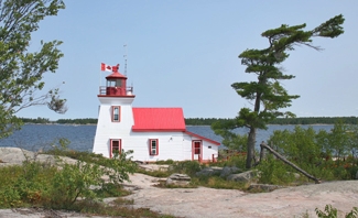
Photo Gallery
Photo Gallery
In 1875, a lighthouse was built on western Gin Island as noted in the Annual Report of the Department of Marine for that year:
During the past season a light-house has been erected [that] will be found serviceable not only for general navigation, but also for guiding vessels into Penetanguishene and Midland Harbours. A catoptric white light, elevated 36 feet above the level of high water, is exhibited, and will be seen at a distance of 10 miles from all points of approach. The tower is a square wooden building, with keepers dwelling attached, and is painted white. The light was put in operation on the 25th of September last. The sum of $1,866.89 was expended on this light-house, as will be seen by reference to Appendix No. 21, and the further expenditure will be shown in the accounts of the fiscal year ending 30th June next. Mr. Israel Mundy was appointed keeper of this light-house on the 15th September last, at a salary of $300 per annum.The total cost for the lighthouse came to $2,765.56. Four mammoth flat-wick lamps and four twenty-inch reflectors on cast-iron stands resting on a round iron table were used in the iron lantern room to produce the fixed white light.
In 1882, William Baxter was appointed keeper of Gin Rock Lighthouse after Keeper Mundy resigned.
At the opening of navigation in 1899, two pairs of day beacons were established to help guide mariners into Severn Sound and its communities of Penetanguishene, Midland, Victoria Harbour, and Port McNicoll. The first pair consisted of a fifteen-foot-pole with horizontal slatwork placed on the northern end of Brébeuf Island and a similar structure with a height of twenty-four feet that was erected on the western shore of Beausoleil Island. These daymarks were separated by 2,400 feet and when aligned guided mariners between the southern end of Giants Tomb Island and Sawlog Point on the mainland. The second pair of day beacons featured a structure near Sucker Creek Point and a second near Midland Point that helped mariners pass safely between the southern end of Beausoleil Island and the mainland.
These day beacons served for just over a year, as in 1900, the Department of Marine replaced them with range lights. Gin Rock Lighthouse, also known by that time as Gin Island Lighthouse, a square, was relocated roughly two kilometres north to Brébeuf Island to serve as the front range light, and a square, forty-two-foot-tall tower that displayed a light from a window near its top was placed on Beausoleil Island to serve as the rear range light. Both lighthouses displayed a fixed white catoptric light at a height of forty feet above the water.
Keeper Baxter moved to Brébeuf Island along with the lighthouse. Keeper Baxter was born in 1857, so would have been appointed keeper when he was twenty-five. He served as keeper until 1931, when he would have been seventy-four, and died in 1944.
Keepers: Israel Mundy (1875 1882), William J. Baxter (1882 1900).
References