Pointe du Lac, PQ
Select a photograph to view a photo gallery
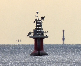
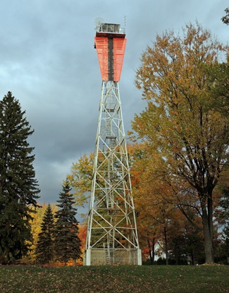
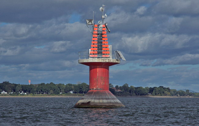
Photo Gallery


Photo Gallery
Photo Gallery
Lake Saint-Peter is thirty-two kilometres long, fourteen kilometres wide, and has been home to several navigational aids to help mariners avoid its shallows and remain in the shipping channel. A lightship was anchored near the centre of the lake in 1816, and one was added to the lakes west end in 1828 and then to its east end as well. These floating lights were known as West Lightship, Centre Lightship, and East Lightship or more cryptically as Lightship No. 1, Lightship No. 2, and Lightship No. 3. The ships helped mark three important turning points in the lake that were known as Curve No. 1, Curve No. 2, and Curve No. 3.
Getting to and from the lightships could be hazard as noted in this report of the drowning of the keeper of the Centre Lightship in 1870:
Mr. Narcisse Arcand, the keeper of the light vessel No. 2 on Lake St. Peter was accidentally drowned on the 4th August, 1870, while coming up in his boat to Sorel for supplies, and his brother Edward Arcand was appointed in his place. The depth of water on the flats of Lake St. Peter is ascertained by the keeper of this light vessel and is marked on the side of the vessel in large figures every day so that vessels passing can see it. A report is made daily for the information of all parties interested, to the Trinity Houses of Montreal and Quebec. At night the figures are seen by the aid of a highly illuminated lamp.
The following improvement was made to the three lightships before the opening of navigation in 1891:
During the past winter the Lake St. Peter lightships were improved by removing from them their masts with the balls which were used for day marks, and by building on them amidships octagonal towers surmounted by the lanterns which previously stood on the decks. This change has had the effect of raising the lights higher above the water and of allowing them to be seen without interruption from all points of approach. The towers on the deck are painted white, and the lanterns white with red roofs. The light in each case is now elevated 22 feet above the water; the illuminating apparatus is a dioptric lens of small size, hung on gimbals, and showing a fixed bright light, which should be visible 9 miles. The cost of this change was $550.
In 1905 1906, two sets of range lights, Louiseville Lower Range and Louiseville Upper Range, were built near Lightship No. 2 to help mark the turning point at Curve No. 2 The Department of Marine provided the following description of this work in its annual report for that year:
The lightship at No.2 curve in Lake St. Peter was removed from her station, and replaced by three permanent lights shown from towers standing on concrete piers, arranged as two ranges with the middle light common to both. This middle tower consists of a square fireproof dwelling painted white with a red roof, surmounted by an octagonal iron lantern painted red. It stands on a rectangular concrete white washed pier with battered sides and a pointed nose upstream. The pier rises 29 feet above the summer level of the river, and stands at the point where the axis of the widened channel from Yamachiche curve to No.2 curve cuts the axis of the widened channel from No.2 curve to No.1 curve. The lighthouse is 28 feet high from the deck of the pier to the ventilator on the lantern, and the light is a fixed white dioptric acetylene light of the fifth order, elevated 49 feet above the water, visible 6 miles. The back lights are similar lights elevated 94 feet above the water and visible 6 miles. Each is shown from a skeleton steel tower, rising from the walls of a fireproof dwelling, standing on a square concrete pier with battered walls. The tower is surmounted by an octagonal iron lantern, the lantern and skeleton framework being painted red, and the dwelling and pier white. The pier rises 29 feet above the water, and the tower is 73 feet high from the pier to the ventilator on the lantern.
Also in 1905 1906, Pointe du Lac Lighthouse on the eastern shore of Lake Saint-Peter was replaced by a set of ranges lights, known as Pointe du Lac Range, to mark the axis of the shipping channel from Nicolet Traverse to Yamachiche Bend. (Pointe du Lac Lighthouse was placed in operation in 1843 to show a turn at the point.) A forty-foot-square cribwork foundation was sunk in twenty-one feet of water near Lightship No. 3 to support the front light, and atop this a concrete deck was placed to bring the top of the pier to a height of twenty-five feet above the lake. This front pier was located 9,640 feet from Pointe du Lac Lighthouse, where a 102-foot, steel, skeletal tower, manufactured by Goold, Shapley and Muir, of Brantford, Ontario was erected for the rear light. When Pointe du Lac Range was activated, Lightship No. 3 was withdrawn for service, but it had to return its station in the spring of 1908 for a period after the front range lighthouse pier was damaged by ice floes.
Heavy ice jams in April 1907 wrecked the pier and lighthouse that exhibited the front lights for the Louiseville Ranges at Curve No. 2 and damaged the rear range towers and piers. Piles were driven around the two rear piers, but the front pier was so badly damaged that it had to be demolished down to the water level. Until the piers and range lights could be repaired, the old lightship was placed back in service. The cost for rebuilding the range lights came to $41,064.87, which was significantly more than their original price tag of $18,851.84.
In 1917, gas buoys were marking Curve No. 1, while the Louisville Ranges marked Curve No. 2 and Pointe du Lac Range helped mark Curve No. 3.
Today, Curve No. 1 is marked by an orange cylindrical tower, with red and white horizontal bands, that was erected in 1973 and is known as Maskinongé Curve Light. The two ranges at Curve No. 2 are known today as Route Louiseville Downstream Range and Route Louiseville Upstream Range, while Pointe du Lac Range continues to mark Curve No. 3.
Keepers:
References