Grondines Upper Range, PQ
Select a photograph to view a photo gallery


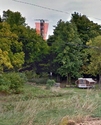
Photo Gallery
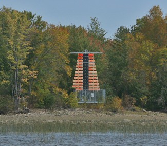
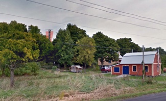

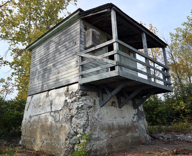
Photo Gallery
Photo Gallery
A pair of lighthouses were built at Grondines in 1857 in the form of square, wooden, towers that formed a range for leading mariners safely past Cap à la Roche. In 1871, the front lighthouse was raised roughly four feet to avoid the annual expense of having to cut down about twenty acres of brush that could obscure the light. Alexander Trottier served as keeper of the lights from 1858 to 1872, after which J. Trottier was placed in charge of the front or lower light and Epiphane Trottier assumed responsibility for the rear or upper light. The following description of the lights was given in 1877, when the two Trottiers were still looking after the lights:
Two fixed white catoptric lights, 1,350 yards apart. Upper tower contains one mammoth flat-wick lamp, 20-inch reflector; size of glass, 32 x 40 x 1/8-inch; and also one No.1 flat-wick lamp, 15-inch reflector.
The lower tower contains one mammoth flat-wick lamp, 20-inch reflector; size of glass, 20 x 38 x 1/8-inch; and one No.1 flat-wick lamp, 15-inch reflector.
Consumes about 70 gallons of oil each per season.
On account of complaints having been made to the Department of insufficiency of the lights in the lower tower, the lanterns were enlarged last summer, and additional lamps put in and the towers repainted.
The lighthouse being unsafe, from age, was re-built this summer, and put in first-class order.
In 1903, an improved shipping channel was dredged above Grondines, and two new pairs of range lights were established to mark the new route. Known as Grondines Point Range and Grondines Upper Range, these lights replaced the original set of range lights at Grondines on the opening of navigation in 1904. The Department of Marine published the following description of the new ranges to publicize their activation:
Grondines Point Range Lights. The axis of the cut dredged through Batture Cap à la Roche, immediately above Cap à la Roche, will be marked by a range of lights to be known as Grondines point range lights.The removal of the old lighthouses and the erection of the pier and new range towers was performed by days labour, under the supervision of Mr. E. Roy, of the Quebec Agency, and cost $2,990.The front light is shown from a tower standing on a concrete pier, built where the low beacon of Grondines point day beacons formerly stood.
The tower is an open steel skeleton frame, square in plan, with sloping sides, surmounted by a square, galvanized iron lantern, the whole painted red. The pier is whitewashed. The tower is 29 feet high from the pier to the ventilator on the lantern.
The light is a fixed white light, elevated 33 feet above the level of the river, and should be visible 7 miles in the line of range. The illuminating apparatus is catoptric.
The back light is shown from the tower heretofore used as a day beacon on the extremity of Grondines point, east of Grondines village church and close to an old stone windmill; it is also 8,260 feet N. 84° E. from the front tower.
It is an enclosed wooden structure, square in plan, with sloping sides, surmounted by a square wooden lantern, the whole painted white. It is 61 feet high from its base to the ventilator on the lantern.
The light is a fixed white light, elevated 66 feet above the level of the river, and should be visible 8 miles in the line of range. The illuminating apparatus is catoptric.
Grondines upper range. The axis of the cut dredged through Batture des Belles Filles, opposite Cap Levraut, will be marked by range lights shown from towers replacing the day beacons formerly marking the same alignment. These lighthouses will be known as Grondines upper range.
The front tower stands on the site of the low beacon, about 2 ½ miles above the Grondines point back light.
The tower is an enclosed wooden structure, square in plan, with sloping sides, surmounted by a square, wooden lantern, the whole painted white. It is 18 feet high from its base to the ventilator on the lantern.
The light is a fixed white light, elevated 28 feet above the level of the river, and should be visible 8 miles in the line of range. The illuminating apparatus is catoptric.
The back tower stands on the site of the high beacon, 6,800 feet N. 62° E. from the front light. It is an enclosed wooden structure, square in plan, with sloping sides, surmounted by a square wooden lantern, the whole painted white. It is 40 feet high from its base to the ventilator on the lantern.
The light is a fixed white light, elevated 68 feet above the level of the river, and should be visible 9 miles in the line of range. The illuminating apparatus is catoptric.
In 1909, the towers used for Grondines Upper Range were replaced by a new, square, twenty-seven-foot-tall, wooden tower for the front light and a forty-eight-foot-tall, steel, skeletal, tower, surmounted by an enclosed wooden watchroom, to carry the rear range light. The steel work from the old rear tower was used in constructing the new one, and the work cost $4,138.70.
At some point between 1955 and 1994, a 103-foot-tall, skeletal tower was erected to display the rear light of Grondines Point Range and a forty-five-foot-tall skeletal tower was erected to display the rear light of Grondines Upper Range. This structure, photographed in 2015 and located near the current front range light, is likely the previous front range light.
Grondines Range:
Grondines Point Range:
Grondines Upper Range:
References