Saybrook Breakwater (Saybrook Outer), CT 

Select a photograph to view a photo gallery

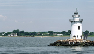
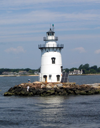
Photo Gallery
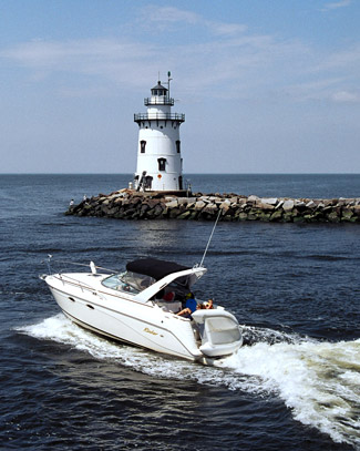


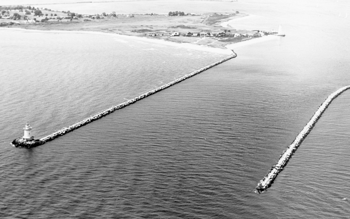
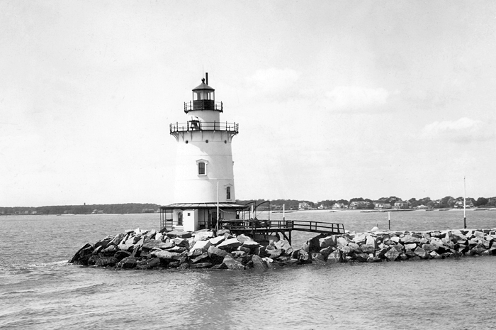


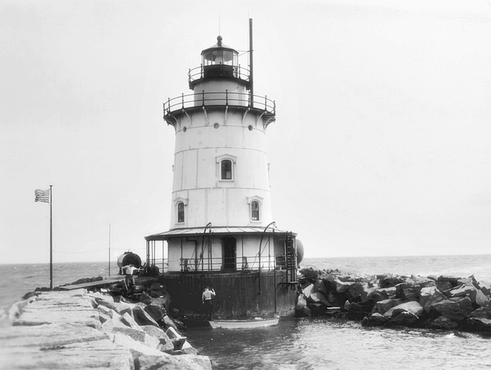

Photo Gallery
Photo Gallery
|
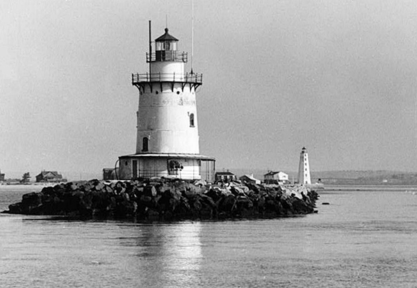
Saybrook Breakwater Lighthouse was one of the first of a number of cylindrical cast-iron lighthouses constructed between the 1880s and the 1920s. G. W. & F. Smith Iron Co., the name of the Boston-based manufacturer of the tower, is inscribed over the entrance door. The forty-nine-foot tower is supported by a cast-iron concrete-filled caisson sunk in seventeen feet of water. The caisson foundation has a diameter of thirty feet, a height of thirty-two feet, and its upper portion flares out to house a basement for the tower. As was customary with this type of structure, the caisson was assembled on land nearby and taken by barge to the site, where it was lowered into the water.
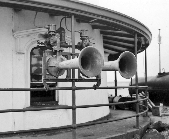
Both the caisson foundation and tower were painted brown until 1892, when the tower was painted white. To warn mariners away from the breakwater during periods of low visibility, the station was equipped with a fog bell struck every twenty seconds. This served until circa 1937 when a diaphragm foghorn was installed. To help with the increased work load caused by the new fog signal, Alfred L. Bennett was assisgned to the station as an assistant keeper under Sidney Z. Gross.
The tower is similar in design to Stamford Harbor Lighthouse, also built in Connecticut in the 1880s. The tower has four floors of living space for the keepers, topped by a watchroom and a twelve-sided lantern room. To prevent heavy condensation from forming on the iron walls during cold weather, the inside of the structure was lined with brick.
Despite this brick insulation, life was cold, damp, and uncomfortable at the station for the keepers. Going to shore for supplies in the twelve-foot rowboat required a hazardous journey fighting the Connecticut Rivers strong currents. A walk to shore along the half-mile-long breakwater was dangerous as well, and even impossible after ice built up on it in the winter.
John Dahlman was serving as keeper of the lighthouse in 1905, when he decided to go duck hunting. Dahlman climbed down the ladder into his boat and was placing his shotgun down when it accidentally discharged and severely lacerated his left arm from wrist to elbow. Mrs. Dahlman frantically sounded a distress signal with the stations fog bell, and the keeper at nearby Lynde Point summoned medical assistance.
|
Noting that the railroad watchmen were also paid more, Woods continued his complaint, I am on duty twenty-four hours out of twenty-four hours and the only relief I get is when my wife begs of me to rest while she stands watch. Woods request was not granted. Rather, he was assigned to a new station, but a few years later, the position of assistant keeper was added to Saybrook Breakwater Lighthouse.
The lighthouse almost didnt survive the legendary hurricane that hit New England on September 21, 1938. Keeper Sidney Gross recorded the following acount of the storm:
At 2 p. m. on the afternoon of September 21 a light southeast breeze sprang up from a perfect calm. At 2: 15 p. m. it became so hazy that it was necessary to start sounding the fog signal. By 3 p. m. it was blowing a gale, and I was unable to step outside the engine room door, the only door through which we can enter or leave the building. I made several attempts to get outside, to save some of the small articles on the platform, part of them not being lashed down, but I found it impossible, as the wind pushed me right back into the engine room. Assistant keeper Bennett also made an attempt to get out and save some of the gasoline for the engines, but the velocity of the wind had been increasing every minute, and we were absolutely helpless as far as saving anything outside the tower was concerning.The tide was coming in, and the water in Long Island Sound and the Connecticut River was becoming rougher every minute. The fog signal was being sounded continuously. At 3 :30 p. m. the water level almost reached the platform, and at that time the gasoline drum and the bridge to the breakwater were carried away. The wind then shifted from the southeast to the southwest, and the water pounded away still harder. At 4 p. m. the platform, encircling the outside of the tower, was torn from its fastenings, and carried away with everything on it, including the 12-foot rowboat.
By this time the water was so high outside that it backed into the cistern through the overflow pipe, spoiling all our drinking water. Dozens of rocks, weighing several tons, were carried away from the breakwater and from around the tower. Some of them were moved as much as 60 feet from their original locations. The wind was so strong that it carried away the tops of the combers in a spray, so that we could see hardly more than 25 or 30 feet from the station. At 4 : 30 p. m., the 1,500-gallon oil tank, which was full of kerosene, was carried away, its straps being snapped just a few minutes previously. At almost the same time, the 600-gallon oil tank was lifted out of its cradle and carried away.
At 5 p. m. the water level was about even with the deck, just a few inches below the engine room floor. As the wind shifted the waves started to pound at the two fog horns and the south window of the engine room. Assistant keeper Bennett and myself boarded up the inside of the window as best we could, but at 5 p. m. the waves were pounding so hard, that all the glass was smashed in and the boards torn out. Tons of sea water started to pour into the engine room. We made other attempts to board up the opening, but the water was too powerful. During these efforts a great wave came through the window, carrying the sash and board with it. As we were both directly in the path, Mr. Bennett got cut on the hand by broken glass, and I was hit on both legs by flying boards. At 5 p. m. No. 1 engine went dead, being shorted by salt water. I tried to continue the sounding of the horn, by running on batteries only, but a few minutes later the automatic switch burst into flames, so I was forced to pull the battery switch to prevent fire. By this time the cellar was completely flooded, and the engine room had about 15 inches of water on the floor. The next thing, both cam motors, together with the stand, were torn from the concrete floor, and landed next to the No. 2 compressor, the fog signal machinery was put hopelessly out of commission.
I could not ring the bell, as it was impossible to get out on the bell deck ; if I had gotten out. I would have been promptly swept overboard. At sunset I disconnected the electric light fixtures, and installed the incandescent oil vapor lamp. The lens was shaking so badly that I expected it to fall off the pedestal and break to pieces. I started up the oil vapor lamp, but the mantles collapsed from the vibration as soon as they were put in place. I then removed the oil vapor lamp and put in the fourth order oil wick lamp. The vibration was so great, and the draft from the wind so strong, that I had to stay up there with the light the whole night, to see that it did not smoke up or go out altogether.
At 6 p. m. the water was pouring in through the second-story window into the hall. I boarded up the window with the doors of a small cabinet and what loose material I could find. At this time I could hear the battery house being broken up. Seven of the batteries and my outboard motor were carried away. Everything outside the building was now carried away, and I certainly did not expect to see another sunrise, as the whole structure was shaking under the violent pounding. When daylight came at last, what we saw seemed more like a bad dream than reality. There was nothing around the tower. Everything was gone except the battery house and even that was badly out of shape.
On May 17, 1939, Keeper Gross sent a letter to his districts superintendent that included the following account of assistance he had rendered:
Early Sunday morning, on the 14th of this month, Mr. Gerard Authier while fishing on the breakwater, accidentally fell overboard. With the aid of some of his friends he managed to get back on to the breakwater. I was attracted by the excitement, went out to see if anyone was hurt or needed help. I found Mr. Authier suffering from immersion and shock and cuts and bruises.I took Mr. Authier right up into the kitchen of the light station, opened up the stove so as to have a good fire, closed the door and the windows in order to have the kitchen plenty warm as he was shaking violently with all the wet clothes on him. He was so cold he could hardly speak a word and lips were all blue with his teeth chattering constantly.
After removing all his clothes, I furnished him warm winter underwear and a flannel shirt, and in the meantime I had the coffee boiling and made him drink plenty of hot coffee while he was sitting right next to the stove getting warm. While I was drying out some of his clothes, which I could not furnish, I attended to the cuts he received when he fell overboard. After about 3 hours next to the stove and drinking plenty of hot coffee, he was feeling pretty good, considering the condition he was in when I took him up to the light station.
While I do not think I have done anything especially noteworthy, I do think that the treatment I gave Mr. Authier saved him from serious aftereffects.
In a letter of appreciation to the district superintendent, Mr. Authier wrote: I am greatly indebted to this man by the name of Sidney Gross; the purpose of my letter is merely to commend the ability and integrity of this lighthouse keeper. I was insulted when, after receiving necessary care from this man, he refused to accept the small sum of $1.00 as a mark of appreciation. You have a very capable man in charge at this point in Saybrook, Conn; and I am sure that you could not find a better man than Mr. Sidney Gross on the entire Atlantic Seaboard.
Saybrook Breakwater Light was automated in 1959, and the Coast Guard began occupying the station only in bad weather, letting personnel at nearby Lynde Point Lighthouse guard the river mouth the rest of the time. Saybrook Breakwater Lighthouse was placed on the National Register of Historic Places in 1990. The tower received a major face-lift in 1996, when a $64,000 project covered the repainting of the tower, the installation of new handrails, and the removal of a generator and 500-gallon fuel tank used as a backup power source in blackouts.
|
The lighthouse currently exhibits a flashing green light, guiding throngs of summer sailors and year-round commercial ship traffic.
After Saybrook Breakwater Lighthouse was placed on the National Historic Lighthouse Preservation Program for 2007, Selectman Michael Pace of the Town of Old Saybrook vocalized concerns over navigational safety and public access should divestiture of the lighthouse occur. On January 30, 2008, a meeting arranged by Congressman Joe Courtney was held so that Selectman Pace could air his concerns with representatives of the Coast Guard and the General Services Administration.
The outcome of the meeting was not highly publicized, but in June of 2008, a Notice of Availability was released making the lighthouse available at no cost to eligible entities defined as Federal Agencies, state and local agencies, non-profit corporations, educational agencies, or community development organizations, for education, park, recreation, cultural, or historic preservation purposes. The Notice of Availability clearly states that the lighthouse can only be reached by boat and that access is via a ladder affixed to the base of the tower. Riprap around the tower forms a small protective harbor for boat access. Two non-profit organizations reportedly submitted a letter of interest by the August 27, 2008 deadline.
Transfer to an eligible entity did not occur, and on May 15, 2013, the General Services Administration opened an on-line auction for the lighthouse. Eight bidders participated in the auction, which ended on August 10, 2013 with a winning bid of $340,000. The lighthouses new owner was Kelly K. Navarro, wife of Benjamin W. Navarro, founder of the debt-collection firm Sherman Financial Group. The Navarros also own two waterfront homes that have a view of the lighthouse in Fenwick, where Katharine Hepburn lived.
When she was unable to sign a lease agreement due to the failure of the state legislature to pass a bill in 2014 authorizing bottom-land leases, Navarro asked for her deposit back. Saybrook Breakwater Lighthouse was placed back on the auction block on July 15, 2015, and this time the new owner should have a much easier time securing a lease thanks to legislation passed by the state in June 2015 that clears the way for the Department of Energy and Environmental Protection to enter into lease agreements for submerged land.
The 2015 auction for the lighthouse attracted seven bidders and closed on September 1 with a high bid of $290,000. The winning bidder was later identified as Frank J. Sciame, Jr., who purchased Katherine Hepburns shoreline estate in 2004 and subsequently renovated the property. I've been looking at it for over 10 years since Ive lived at the house, Sciame said. Its something that everyone sees if you buy a property in the borough of Fenwick. Its an important part of the seascape. Sciame, a New York builder, planned to restore the outside of the lighthouse and transform the inside into a livable space, but then in 2016, he placed the lighthouse on the market as part of the former Hepburn estate.
In Februrary 2017, an article in the New York Post revealed that Sciame had hired yacht-design architects Persak & Murmfeld to transform the lighthouse into a clubhouse for his grandchildren. Ive decided to spend more time with my family using our boat, and the lighthouse is the perfect way to keep a connection to Fenwick after weve sold the Hepburn house, Frank Sciame said. The Hepburn estate has been divided into three parcels, one with the 1939, six-bedroom home used by Hepburn, one with a three-bedroom home built in 2015, and one which is still a vacant lot. Sciame plans to sell off all three properties.
The first floor of the lighthouse will feature an entrance foyer and storage, while a master cabin will take up the second floor and a kids cabin with bunk beds will be on the third floor. A living room area and a galley kitchen will fill the fourth floor, and the fifth floor will be converted into a bar with an outdoor deck. A 2021 article in The Wall Street Journal noted that Sciame has sleepvers in the lighthouse with his grandchildren and spent hundreds of thousands of dollars on the lighthouse to teach his grandchildren about historic preservation.
Keepers:
References


