Malpeque Outer Range Front, PE 
Select a photograph to view a photo gallery
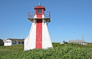
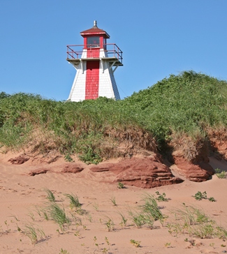

Photo Gallery


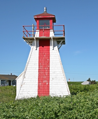
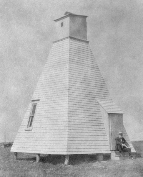
Photo Gallery
Photo Gallery
|
The requested Darnley Point Range Lights, however, were not built until 1889, and even then they were quite rudimentary each consisting of a lantern hoisted atop a 9.1 metre (30 foot) mast with a shed at its base. The rear light was located 440 metres (1,444 feet) southwest of the front light, and both of the lights were fixed red. John D. Morrison was appointed the first keeper of the range lights and was replaced upon his death in 1890 by Cornelius Morrison, who served until 1896.
In 1892, diamond-shaped slat-work formerly used on the masts at Brighton Beach were bolted to the masts at Darnley Range and stayed with steel wire rope to make the masts more conspicuous in daylight. Due to the unsteadiness of the mast arrangement, open-frame towers topped by enclosed lanterns were erected in 1897 under the supervision of Milton Walsh, foreman of works for the Prince Edward Island Division of the Department of Marine and Fisheries. The two towers were 7.6 metres (25 feet) tall and cost a total of $170.0 for material and labour.
In 1908, the Darnley Point Front Range Light was described as a square, white, open-frame structure with slating on its seaward face. This structure displayed a fixed red light at a focal plane of 12.2 metres (40 feet). Its companion light was a similar structure situated 409 metres (1341 feet) farther inland that displayed a fixed red light at a height of 19.8 metres (65 feet) above high water. These structures were later enclosed to become the current towers.
Daniel Champion became keeper of the range lights in 1935 upon the death of Cornelius Morrison and served in this role until the lights were electrified in 1962. Keeper Champion was earning an annual salary of $720 in 1962, and after electrification of the lights, he agreed to serve as their caretaker at an annual salary of $100.
The Canadian Coast Guard now refers to the Darnely Point Range Lights as the Malpeque Outer Range Lights in its official List of Lights. Fixed red lights are still displayed from the towers. The front and rear towers have a height, respectively, of 7.8 metres (25.6 feet) and 7.7 metres (25.3 feet) with focal planes of 12.6 metres (41.3 feet) and 21 metres (68.9 feet). The two towers are very similar except the front tower has corner boards and wooden gallery support brackets, while the rear tower lacks corner boards and has iron support brackets. A red vertical stripe on the seaward face of the towers helps mark the range line.
Malpeque Outer Range Front Light was registered by the Prince Edward Island Historic Places Protection Act on July 12, 2012.
Keepers: John D. Morrison (1889 1890), Cornelius Morrison (1890 1896), G. W. J. Wiggins (1896 1913), Cornelius Morrison (1913 1935), Daniel Champion (1935 1962).
References

