Rock of Ages, MI 
Select a photograph to view a photo gallery

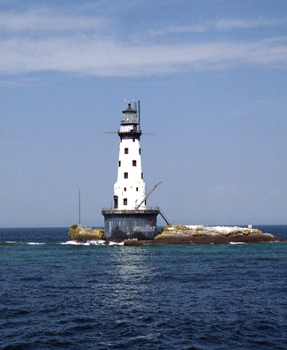
Photo Gallery
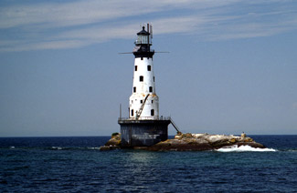

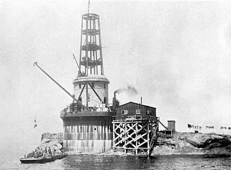
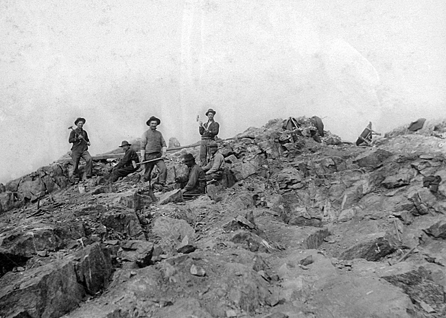
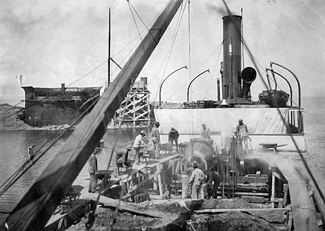
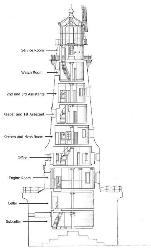
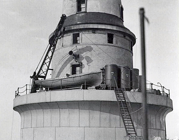


Photo Gallery
Photo Gallery
The Lighthouse Board repeated its request for $50,000 each year until 1900, when it finally upped its estimate to $125,000. This increased amount was requested annually until 1903, when the Board asked for $25,000 to survey the site, prepare detailed plans, and commence construction. This change in tactic worked, and Congress provided $25,000 on March 3, 1905. This amount was followed by $50,000 appropriations on June 30, 1906 and March 4, 1907 to complete the funding for the lighthouse.
|
Over the next few months, a cylindrical wall with a diameter of fifty feet was built using heavy steel plates riveted together and anchored to the rock. The twenty-five-foot-tall cylinder was filled with concrete to create the foundation pier, and a structural steel framework was then erected atop the pier to serve as skeleton for the lighthouse, whose walls would be built of brick and trimmed with cut limestone.
After work began on the tower, a timber platform was built at the level of the pier deck to support a bunkhouse capable of accommodating thirty men. This onsite housing eliminated the twice-daily, ten-mile-trips to and from the rock, greatly improving the efficiency of the operation.
During the tempestuous fall weather, supplies could only be delivered to the rock in the rare periods when the sea was calm, and on more than one occasion, food supplies ran dangerously low, forcing the men to live on short rations until the weather improved. Ralph Tinkham, an employee of the Russel Wheel & Foundry Company of Detroit, helped Charles Keller design the lighthouse, and then in 1908 resigned his position with the company to become Superintendent of Construction for the Lighthouse Service. Tinkham personally supervised work on the lighthouse during 1908 and recorded the following incident that occurred while living at the tower:
One day while busy on one of the upper floors of the tower, there came to my ears a sudden commotion and much shouting from outside. Going quickly to a window in the tower overlooking the living quarters and platform, I saw the cook wildly chasing the cookee around the gallery, wielding a big butcher knife in his hand and yelling imprecations. Hurrying down the tower to the pier deck I emerged just as the cook had been intercepted by some of the men, and the cookee had disappeared into the bunkhouse. The cook was a veteran of logging camps with gray in his hair, the cookee a youngster in his teens who took delight in baiting the cook, often heretofore to the amusement of the workmen. This time he had gone too far with his practical jokes, and, for a hectic few minutes, the cook was bent on revenge with mayhem in his heart.
|
Work on Rock of Ages Lighthouse had progressed sufficiently that a temporary third-order fixed red light could be established in its lantern room on October 22, 1908. On the same date, a first-class six-inch siren was placed in commission, which was also overseen by Keeper Thomas E. Irvine and his assistants. An act passed on March 4, 1909 provided $15,000 for a second-order Fresnel lens, which was ordered from the Parisian firm of Barbier, Benard, and Turenne later that month.
During July and August of 1909, floors were laid, radiators were placed and connected, the foundation pier was paved and encircled with a chain rail, and the landing crib was completed. Rock of Ages Lighthouse was now complete save for the installation of its permanent lens, which was finally accomplished on September 15, 1910.
The following description of impressive Rock of Ages Lighthouse was printed by the Lighthouse Service in 1912:
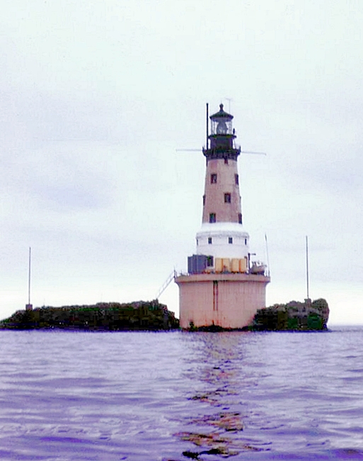
Site.The station is located off the west end of Isle Royal, northwestern end of Lake Superior. The site consists of a jutting rock ridge about 50 feet wide, 210 feet long, and maximum elevation 16 feet above lake level.Structure.The lighthouse is of brick, with concrete trim and incloses a steel skeleton framework. It is cylindrical in shape at the base and conical for the upper part and rests upon a massive steel plate concrete-filled pier built upon the rock at about water level. The steel plates are riveted together, stiffened with angle irons, and tied back to the concrete by anchor rods. The pier is 50 feet in diameter up to a point below the deck, where it is trumpet shaped, enlarging to 56 feet in diameter 30 feet above water. The lighthouse supports a cast-iron gallery, watch room, and first-order straight-bar lantern, whose focal plane is 87 feet above the deck of the pier. The watch-room gallery floor is supported upon ornamental cast-iron brackets.
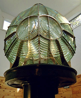
Illuminating apparatus.The illuminating apparatus consists of a second-order flashing lens of 4 panels, each made up of 7 refracting and 17 reflecting prisms, rotating on a mercury float, driven by clockwork, and giving a double white flash every 10 seconds. The intensity of each flash is estimated at 940,000 candlepower. The focal plane of the light is 117 feet above mean lake level and is visible 19 miles in clear weather. The light is furnished by a 55-millimeter double-tank incandescent oil-vapor lamp.
Fog signal.This consists of duplicate 6-inch automatic sirens blown by compressed air. The compressing plant consists of two 24-horsepower vertical petroleum engines and compressors, on the same bed, direct connected to the same shaft. The machinery is located on the first floor of the tower.
Quarters.The tower is eight stories in height. There is a subcellar immediately above the foundation rock. Above this is the cellar with the heating plant and water tanks; then the first floor, about on level with the deck outside, containing the fog-signal plant and hoisting engine for the pillar crane. Then follow the office on the second floor, mess room and kitchen on the third, keepers and first assistants rooms on the fourth, second and third assistants rooms on the fifth floor, and the service room and watch room on the sixth and seventh floors. Quarters are provided for the four keepers only. A hollow cast-iron newel post extends from subbasement floor to watch-room floor. Supplies are landed at the station by boat from the tender upon a landing pier, 11 by 24 feet, on the southeasterly side of the tower, thence by crane to the deck of the main pier. The keepers boats are stowed on the deck of the main pier.
|
A few days after the Marigold called at the lighthouse, Robert Morrill, one of the stations keepers, arrived in Duluth bringing word of the safety of his companions. The four men had planned to land in Grand Portage, but when heavy ice floes made that impossible, they landed at Pigeon Point and took refuge with a fishermen. Morrill later rowed to Hat Point, spending the night en route on a small island, and then walked through waist-deep snow to Mineral Center, from where he was transported by boat to Duluth.
A radiobeacon was established at Rock of Ages in 1929, and the following year the intensity of the light was increased through the introduction of an electric light in the lens. In 1931, a tyfon fog signal was installed in the lighthouse with horns extending from opposite sides of the tower to produce a better distribution of sound.
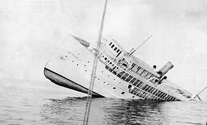
Keeper John F. Soldenski and his three assistants were commended by the Secretary of Commerce in 1933 for their role in the safe landing of 116 people from the 270-foot passenger steamer George M. Cox at the lighthouse. The following account of the shipwreck was printed in the Lighthouse Service Bulletin:
On May 27 the passenger steamer George M. Cox, with 127 persons on board, bound from Houghton, Mich., to Port Arthur and Fort William, Ontario, stranded in fog on the reef a short distance from Rock of Ages Light Station. The sea was calm so that the passengers and crew were able to reach the light station in safety. There was not room for all of the people inside the light tower, so the crew and passengers spent a chilly and uncomfortable night; they took turns inside to warm themselves spending the rest of the time huddled on the bare rocks outside. On the following day all persons were removed to the shore, except certain representatives of the owner of the vessel. All signals at Rock of Ages Light Station were operating at the time of the disaster; the radiobeacon had been in operation 3 hours and the sound fog signal 1 hour. These two signals are arranged to furnish a means of obtaining the distance from the station.The radiotelephone at Rock of Ages Light Station was used to send out a general call reporting the accident. A former call sent from the ship itself had been successful, however, in giving information as to the disaster. The radiotelephone at the station was used to very good advantage in informing the district office of the accident, and as to the fact that aids to navigation were in no way involved, also in handling a number of important messages for the vessel owners in connection with the disaster.
|
In July 1939, twenty-seven-year-old Robert D. Bergmarker and two other crewmen aboard the lighthouse tender Amaranth were loading machinery from the tender to a scow at Rock of Ages Lighthouse, when the machinery slipped, pinning the men against the tender. One coastguardsman escaped with just a slight wound, but another suffered several fractured ribs and a fracture right fibula, and Bergmarker was fatally injured. The scow later capsized, dumping the machinery into the lake.
The lighthouses daymark was originally listed in Light Lists as a buff conical tower, but in 1959, the tower was painted, and its daymark was subsequently described as a white conical tower. The lighthouses final Coast Guard crew was withdrawn at the end of the 1977 shipping season.
In 1985, the massive second-order Fresnel lens was removed from the lighthouse and placed on display at the Park Services Windigo Visitor Center in Washington Harbor. The Houses Merchant Marine and Fisheries Committee adopted an amendment that would have required the Coast Guard to transfer the lens to Keweenaw County Historical Society, which planned to display the lens at Eagle Harbor, but this effort failed.
Rock of Ages Lighthouse Preservation Society was formed in 2008 with a mission to restore the tower as a monument to the skilled craftsmen who built it and the dedicated keepers stationed there. The groups first work trip to the lighthouse occurred in August 2014, and several other trips have since taken place.
Keepers:
References

