Rock Harbor, MI 
Select a photograph to view a photo gallery

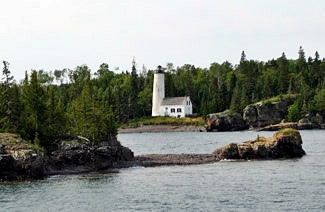

Photo Gallery
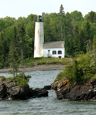

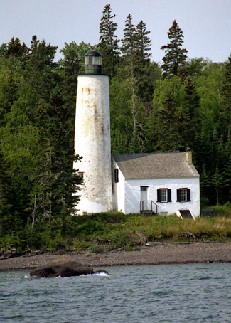
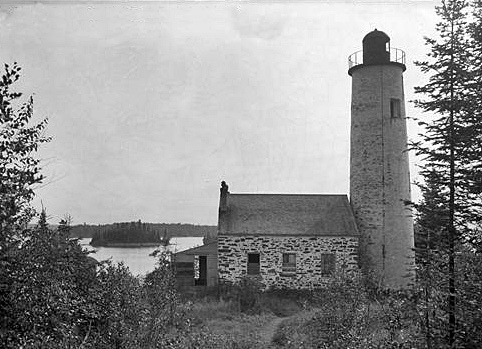


Photo Gallery
Photo Gallery
In 1852, Henry B Miller, superintendent of lights on the upper lakes, recommended that $5,000 be appropriated for a lighthouse at Rock Harbor on Isle Royale. Although the Lighthouse Board was unsure if the light was really needed, it still backed the project as the law required the topographical bureau to report on the necessity of the light before it was built. Congress allocated $5,000 for Rock Harbor Lighthouse on March 3, 1853, and the topographical bureau must have sanctioned its construction as a contract for the lighthouse was awarded in 1854 to the firm of Alanson Sweet, Luzerne Ransom, and Morgan E. Shinn, who also built lighthouses at North Point, Grand River, LaPointe, Portage River, Grand Island, Point Iroquois, Eagle River, Point Betsie, Pointe aux Barques, Round Island, and Menasha.
|
In 1859, Congress authorized the Secretary of the Treasury, on the recommendation of the Lighthouse Board, to discontinue from time to time, such lights as may become useless by reason of the mutations of commerce and changes of channels of harbor, and other causes. Mining on remote Isle Royale had proved unprofitable, and with little shipping using Rock Harbor Lighthouse, the Lighthouse Board discontinued it in August 1859.
T.H. Stevens, inspector for the eleventh district, visited Rock Harbor Lighthouse a decade after it had been abandoned and submitted the following report on its condition:
Dwelling found to be a substantial structure in a good state of preservation. The walls apparently perfectly solid. The floor and plastering in good condition except that the plastering was disfigured with charcoal sketches but not seriously injured. The Locks were off the Doors and some of the glass in the windows broken. There is an excellent cellar under the whole dwelling. The tower is connected to the dwelling by a short covered way. The walls of which were quite badly cracked, and there were slight cracks in the walls of the tower but not of a serious character. The lantern is glazed with Plate glass which is in good condition and free from scratches.The remoteness of the lighthouse had apparently limited vandalism.
In December 1872, John T. Whiting, an agent for the Western Transit Company, which operated steamers between Buffalo and other ports on the Great Lakes, wrote to Orlando M. Poe, engineer for the eleventh lighthouse district, requesting that Rock Harbor Lighthouse be relighted due to the planned resumption of mining operations on Isle Royale and the increase in commerce on Lake Superior that passed by the island on the way to and from Duluth. Poe agreed with Whitings request and sent a letter to the chairman of the Lighthouse Board recommending that $10,000 be appropriated to reestablish the light in the interest of the general commerce of the Lake.
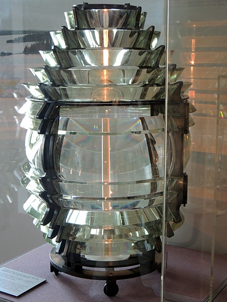
On June 23, 1874, Congress allocated $5,000 for repairing and rebuilding Rock Harbor Lighthouse, and shortly thereafter a work party was dispatched to Isle Royale with all the necessary material for repairing the lighthouse along with a fourth-order L. Sautter Fresnel lens. A Notice to Mariners was published announcing that on or about the night of August 5, 1874 a fixed red light would be exhibited from the old tower situated on the west side of the entrance to Rock Island Harbor, but with work being finished sooner than anticipated, the light was activated on July 25.
|
Keeper Kruger was removed from the office of head keeper in October 1877 and replaced by Martin R. Benson. Roughly a year later, an ailing Kruger wrote to Godfrey Weitzel, the district engineer, requesting to be reimbursed $82.85 for two docks, a barn, and a hay shed that he had built at the station. To justify the need for these structures, Kruger provided the following explanation of their use:
The barn and shed I built to keep cow, pigs, & fowl to live on through the winter. The docks I was incoraged [sic] to build by Cmdr. McCann to save boats from going on the beach in landing supplies, etc. and for my own benefit. As I should probably remain there yet if it had not been for malice and revenge of scoundrels, as I was innocent of the chargers proffered against me.Weitzel forwarded Krugers request to the Lighthouse Board, noting that the prices paid by Kruger for materials were fair and reasonable and that all isolated stations like Rock Harbor should be equipped with a dock and barn.
With the completion of Menagerie Island Lighthouse on the south shore of Isle Royale and the abandonment of mining operations on the island, Godfrey Weitzel recommended in July 1879 that Rock Harbor Lighthouse be discontinued. The Lighthouse Board complied with the recommendation, and the lighthouse was discontinued at the close of the 1879 shipping season.
During an inspection of Rock Harbor Lighthouse in 1879, it was noted that Keeper Benson had done more to improve the appearance of the grounds [of his station] than any other Keeper in the District. Bensons diligence was rewarded with a transfer to Portage Lake Ship Canal Lighthouse.
In 1902, the Lighthouse Board reported that recent development of mines on the island had once again resulted in an increase in commerce and requested funds for a light to mark Rock Harbor. The Board repeated its requests annually until 1907, but Rock Harbor Lighthouse was never brought back to life for a third time.
Rock Harbor Lighthouse was used as shelter for camping parties, and then between 1927 and 1939, Arnold and Milford Johnson used it as a base for their commercial fishing operation. The lighthouse became part of Isle Royale National Park, when it was established in 1940, but little attention was paid the lighthouse until an emergency stabilization was carried out in the late 1950s to save the tower.
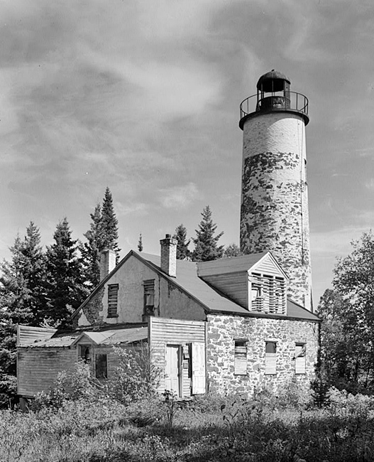
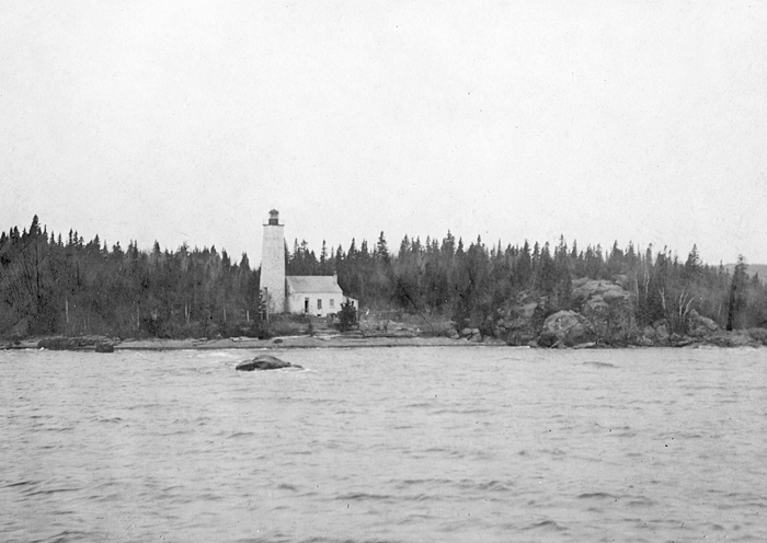
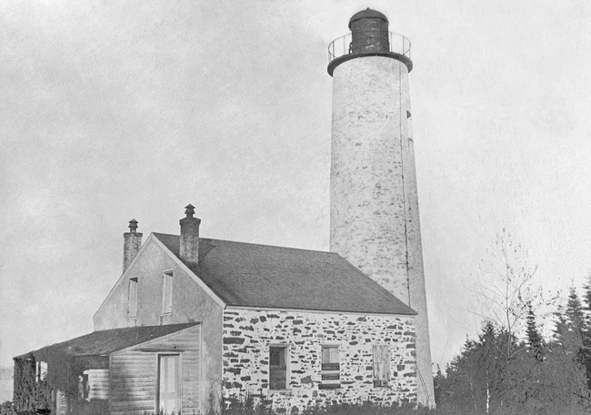
The interior of Rock Harbor Lighthouse, the oldest standing lighthouse on Lake Superior, is now home to a museum, which includes a fourth-order Fresnel lens. Access to the site is by boat from Rock Harbor Lodge.
Keepers:
References
