Grand Marais, MI 


Select a photograph to view a photo gallery
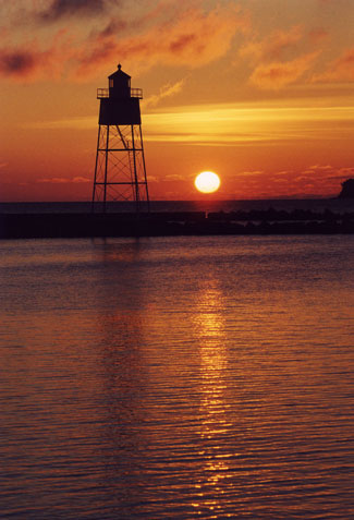


Photo Gallery

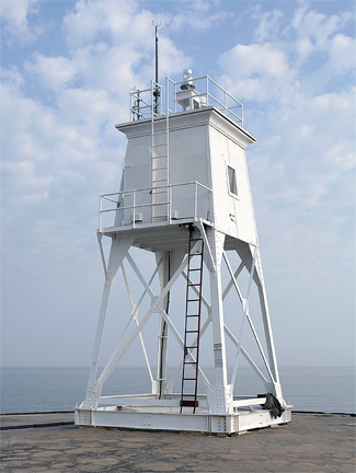
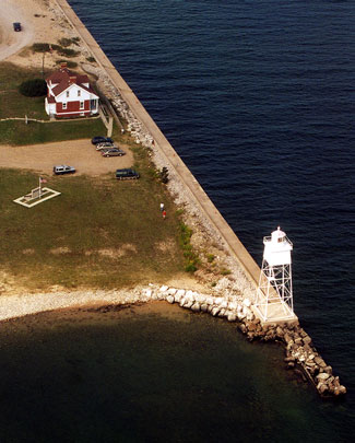
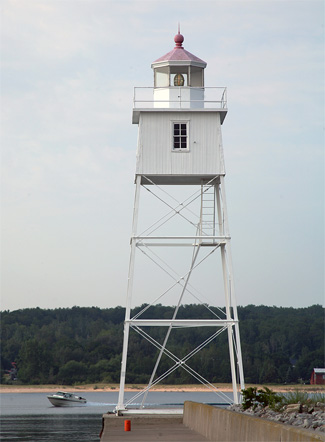
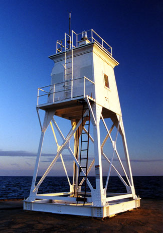
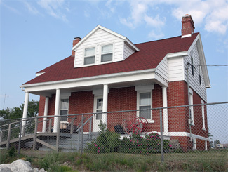
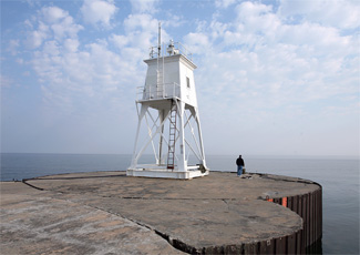
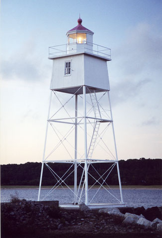


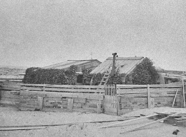
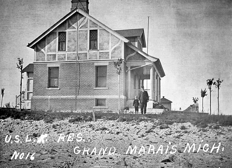
Photo Gallery
Photo Gallery
|
In its 1892 annual report, the Lighthouse Board made the following request for funds to erect a light for the new harbor of refuge.
There is no harbor between White Fish Bay and Grand Island. Grand Marais has been for some time under improvement by the United States as a harbor of refuge, and the work has now advanced to a point where it is desirable to light it. It is estimated that a suitable light and bell can be established here at a cost not exceeding $15,000, and it is recommended that an appropriation of this amount be made therefor.
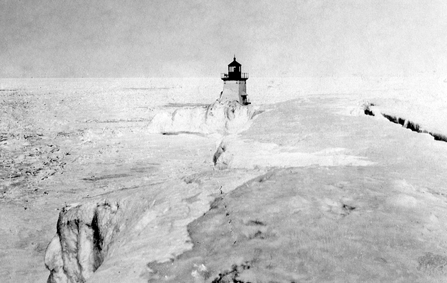
Congress provided the requested amount on March 2, 1895, and in November of that year, the Point Iroquois bell tower, which had been replaced by a steam fog signal, was taken down and transported to Grand Marais, where it was bolted to the western pier and capped with a decagonal iron lantern room. The square, pyramidal tower stood forty-three feet tall, was open at its base, and had two enclosed rooms, one above the other, just beneath the lantern room. The upper room served as a service room for the light, while the lower room housed the striking apparatus for the fog bell and opened onto an elevated wooden walkway that led shoreward. The towers fixed white light and fog bell were placed in operation on December 10, 1895 by Keeper Samuel F. Rogers, who had previously been in charge of Spectacle Reef Lighthouse in Lake Huron.
After completing the pierhead light and bell, the Lighthouse Board had enough funds to construct a keepers dwelling and a second light to form a range, but as the appropriation was for just a light and bell, it had to ask for authorization to repurpose the money. On June 4, 1897, Congress passed an act that allowed the Lighthouse Board to build an additional light and complete the station as long as it didnt spend more than $2,000. A contract for a metal tower was made on September 27, 1897, and the tower was delivered to the depot in Detroit roughly two months later. After the inner end of the west pier had been strengthened, the metal tower was erected upon it the following June, and the rear range light was first exhibited on July 18, 1898.
|
The addition of a rear range light took priority over a keepers dwelling. Keeper Rogers, who was used to cramped quarters after having spent many years in the U.S. Navy, had been forced to build a small shack near the pier out of driftwood. Having spent most of his life at sea or at offshore lighthouses, Rogers, a bachelor, never owned any property before moving to Grand Marais in his sixties. A highlight of his Naval career was serving aboard the San Jacinta, which in 1860 captured the brigs Storm King and Boneta off the east coast of Africa and liberated nearly 1,300 slaves bound for the United States.
In repeated funding requests for a keepers dwelling at Grand Marais, the district inspector described Keeper Rogers make-shift accommodations as a miserable shanty neither decent nor healthful, a disgraceful affair, and the poorest kind of hut. Congress finally provided $6,500 for a new dwelling on February 26, 1907, but it was too later for Keeper Rogers, whose ill health forced him to resign in 1904.
Work on the keepers dwelling commenced June 10, 1908, and by the end of the month the concrete footings were laid, the foundation walls had risen to a height of six feet, and construction of the cistern had started. By the end of September, Keeper George Barkley was able to move his family into the new dwelling, which is similar to one built the same year for the range lights at Munising.
In 1905, the characteristic of Grand Marais Range Lights was changed from fixed white to fixed red so mariners could differentiate them from the lights along the shore, and the front tower was moved seaward near the end of the recently extended pier. An elevated metal walkway, 560 feet long, was built to bridge the gap between the existing walkway, and the front tower in its new location. A storm on January 6, 1906 carried away roughly 250 feet of the new walkway, but it was replaced the following May. A fireproof oil house was built near the keepers dwelling in 1909.
In November 1919, the 889-ton steamer H.E. Runnels had sought refuge at Grand Marais from a northwest gale, but on the morning of November 14, the captain decided the storm had abated and steered his ship back out into Lake Superior. After rounding Point Au Sable, eight miles west of Grand Marais, the Runnels encountered sixty-mile-per-hour winds, and the captain wisely decided to return to the harbor of refuge.
|
In November 1922, the fog signal in the front light was changed from a bell to an electric siren, and the light was changed from fixed red to a red flash every two seconds. Then, on June 12, 1923, the fog signal was changed to an air diaphone, sounding a one-second blast every fifteen seconds. At some point, the current steel tower replaced the old wooden bell tower used for the front range light.
Roger W. Campbell, keeper of the range lights in the 1930s, had twelve children with his wife Viola, before she passed away in the late 1920s. In 1933, Keeper Campbell made the local newspapers when he went to visit his son Lloyd at the Whitefish Coast Guard Station and became trapped there by two snowstorms, leaving his six motherless children all alone back in Grand Marais.
The Grand Marais Historical Society received ownership of the keepers dwelling in 1984, and the restored residence is now a museum displaying items from the early 1900s.
Head Keepers: Samuel F. Rogers (1898 1904), George A. Barkley (1904 1916), Otto Bufe (1916 1922), Herbert P. Crittenden (1922 1927), Roger W. Campbell (1927 1935), Thomas E. Radcliff (1935 at least 1941).
References


