Isle La Motte, VT 
Select a photograph to view a photo gallery
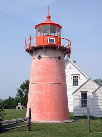


Photo Gallery

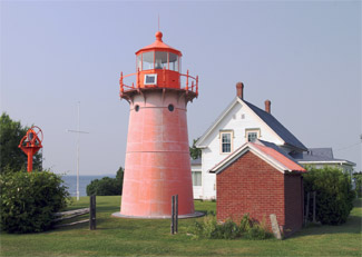
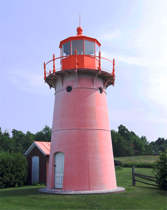

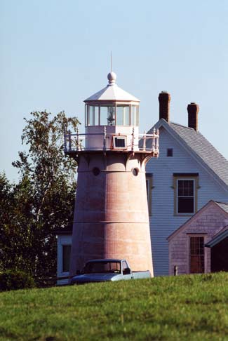
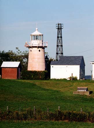

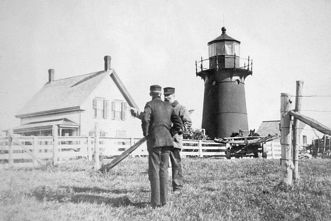

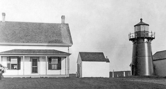

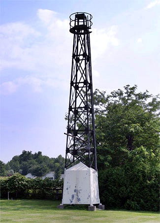
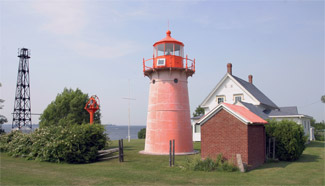
Photo Gallery
Photo Gallery
|
In 1853, Henry B. Smith, collector of customs at Plattsburgh, New York, recommended that the Lighthouse Board spend $5,000 to erect a lighthouse on the northern end of Isle La Motte. That same year, William D. Fraser of the Corps of Engineers reported that lighthouses were needed on Lake Champlain at Windmill Point and Crown Point along with small bug lights on Burlington Pier and on Isle La Motte, which would cost but $500 each. The plan for a small light on Isle La Motte was selected, and in 1856, the U.S. government purchased a parcel of land on the island for $50.
The private light formerly maintained on Isle La Motte by a steamboat company was replaced with a limestone tower supporting a large lens lantern. The conical tower rested on a rectangular base, where it had a diameter of five feet, and rose to a height of eighteen-and-a-half feet, where its diameter was two-and-a-half feet. An iron ladder mounted to the outside of the hollow tower provided access to a walkway that encircled the lantern. A local farmer was paid to tend the light, but on stormy nights, when the light was so critical, the lamp would often blow out.
In its annual report for 1868, the Lighthouse Board wrote the following about the light at Isle La Motte: It is proposed to build a dwelling with a lantern on top, from which to exhibit the light. The land necessary for the site is now in possession of the government, and an estimate of the cost of the requisite structure is submitted.
Three years, the Lighthouse Board added, the distance between the residence of the keeper and the beacon is too great to secure proper attendance, and requested $8,000 to build the keepers dwelling surmounted by a light tower.
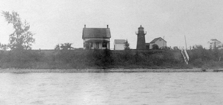
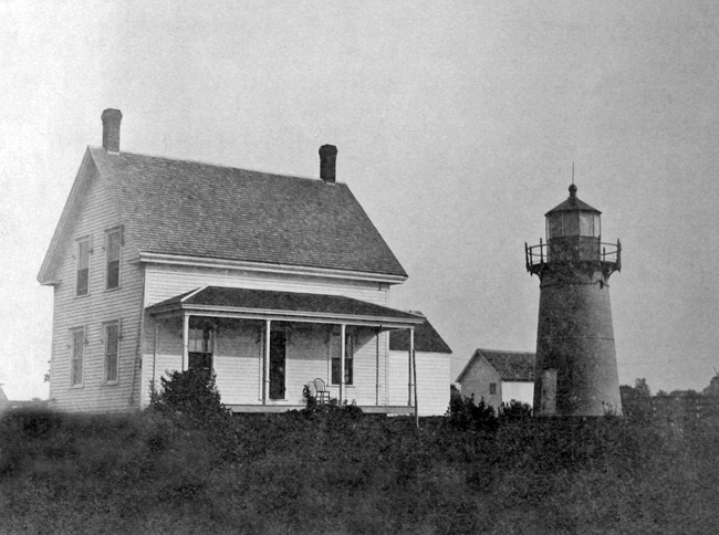
Authorization for a lighthouse was granted in 1879, but instead of a light atop a dwelling, a twenty-five-foot-tall tower made of curved cast-iron plates was erected along with a detached one-and-a-half-story keepers cottage. The tower, similar to those now at Point Montara, California, Sunken Rock, New York, Crossover Island, New York, and Ten Pound Island, Massachusetts, held a sixth-order Fresnel lens, which shone a fixed white light at a focal plane of forty-six feet. Keeper Wilbur F. Hill exhibited the light for the first time in 1881. The brick oil house was added to the station in 1906.
The iron tower, originally painted bright red, has an Italianate cast railing, porthole windows, and molded cornices. Over time, it has faded to a light pink, called Nantucket red by the locals.
When work on the lighthouse was underway in 1880, a local landowner claimed ownership of the lighthouse lot and objected to its occupation without proper remuneration by the government. To this claim, the Lighthouse Board responded: Keeper Hill retired at the end of January 1919 after nearly fifty years of service at the station. As Keeper Hill passed away on March 19, 1919, before his replacement had been appointed, his daughter Gladys looked after the station until William W. Grant arrived on April 18 to serve as the new keeper. Grant had not served as a lighthouse keeper before, but had been an engineer on lighthouse tenders for over twenty years and his father and grandfather had both served at Matinicus Rock Lighthouse in Maine.
Keeper Grant gave the following description of his responsibilities in 1928:
Twice a week, I clean the window glass by taking ammonia and water and a machine wiper and washing them outside and in. Then the decks and stairs.
Between these jobs, I do work around the house, barn, and grounds such as cutting the grass on the lawn with a lawn mower and clipping around house and fences with sheep shears.
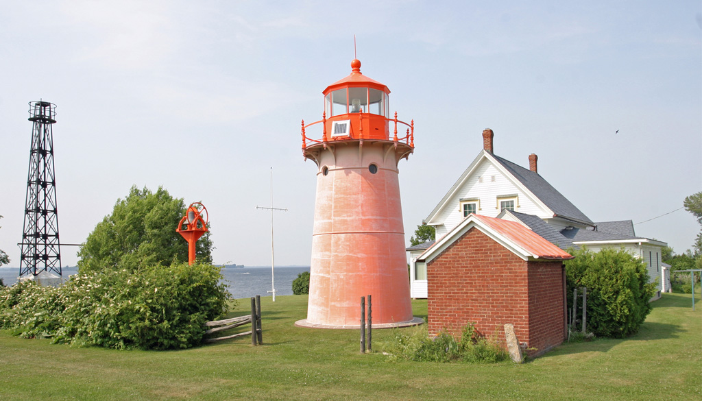
Once a year, I oil my lighthouse and oil house and whitewash my shed, hen house, and toilet. As part of a cost saving measure in the 1930s, the Lighthouse Service replaced many of the lighthouses on Lake Champlain with steel skeletal towers. One such tower, with a tank house at its base and topped by an automatic beacon, was erected on Isle La Motte light in 1933. Keeper Grant was informed his light would be automated at the end of June 1933. He served for one month at Block Island Southeast Lighthouse before being retired on disability. Keeper Grant was allowed to remain at Isle La Motte Lighthouse until the station was sold into private hands.
One day Erika Clark was having a dental checkup in Chazy, New York, just across Lake Champlain from Isle La Motte, when her dentist asked if her father would be interested in purchasing Isle La Motte Lighthouse. The answer turned out to be yes, and Robert C. Clark acquired the lighthouse in 1949 from Nelson Hill, a relative of the Clark familys dentist. The Clarks, then consisting of Robert and his two children, Lockwood and Erika, had previously enjoyed a small camp on Isle La Motte near St. Annes Shrine and were happy to acquire a larger parcel on the island.
In 2001, the Coast Guard considered the cost of replacing the deteriorating steel tower at Isle La Motte and determined it might be more cost effective to return the light to the original tower. With the cooperation of the Clark family, the lights at Isle La Motte and Windmill Point were returned to their rightful place atop the historic towers. The pedestal for the light had been removed from Isle La Motte Lighthouse, so the Clarks used the one left at Windmill Point as a pattern for building a new one for Isle La Motte. The Clarks also crafted and installed the mount and conduits for the solar panels needed at each of the lighthouses.
After almost seven decades of darkness, Isle La Motte Lighthouse was restored to active service on October 5, 2002. The event was witnessed by a crowd of over 300, and the actual lighting was accompanied by the firing of a cannon and the vigorous tolling of a nearby bell by Lucky Clark. The light was relit by the schoolchildren of Isle La Motte led by Lois Cameron, great-granddaughter of Keeper Wilbur Hill, who first lit the light in the current tower in 1881. To cap off the program, the crowd joined in singing This Little Light of Mine.
In a January 2014 press release, the Coast Guard announced their intention to demolish or remove the metal, skeletal towers at Split Rock and Isle La Motte: Both towers are of an obsolete design that does not meet current Coast Guard requirements for aids to navigation structures and are unsafe for Coast Guard personnel to climb for maintenance. Both towers present a safety hazard to persons on adjacent private properties and both towers present an environmental hazard due to deteriorating paint. Neither of the towers is an active aid to navigation. A deadline of May 1, 2014 was set for finding a new owner for the metal tower, but the Coast Guard eventually relented and let the tower at Isle La Motte remain standing.
On October 16, 2018, the Coast Guard installed an LED beacon in the lantern room of Isle La Motte Lighthouse.
Head Keepers: John D. Reynolds (1857 1862), Ezra Pike, Jr. (1862 1871), Wilbur Fisk Hill (1871 1919), William W. Grant (1919 1933).
References
The land has been in the undisputed possession of the government for more than twenty years, and the claim to ownership is undoubtedly made to extort money from the United States. The only basis for the claim is the fact that an informality has occurred in the matter of recording the deed to the government, and this is more due to the town clerk of Isle La Motte than anyone else.
In the morning, I turn out at sunrise and go out to the lighthouse, unlock the door, and go up and take down the lamp out of the lens, blow it out, and set it down on the deck. I then put on the lens cover. Then I put up the window curtains after looking as far as I can see on the lake for wrecks or drifting boats. Then I take the lamp and go down to the base of the tower. I fill the lamp, clean the chimney, then I go out, lock the door, putting the key in my pocket.
Lockwood (Lucky) Clark purchased Windmill Point Lighthouse in 1963 from Emil Bayer of Connecticut. After his wife passed away, Emil returned to Lake Champlain to visit the lighthouse he had owned for fourteen years, and ended up falling in love with Erika Clark. The two were married in 1968, and Erika moved away from Lake Champlain. Emil died in 1981, and a few years later Erika moved back to Lake Champlain to live in the dwelling at Isle La Motte Lighthouse.
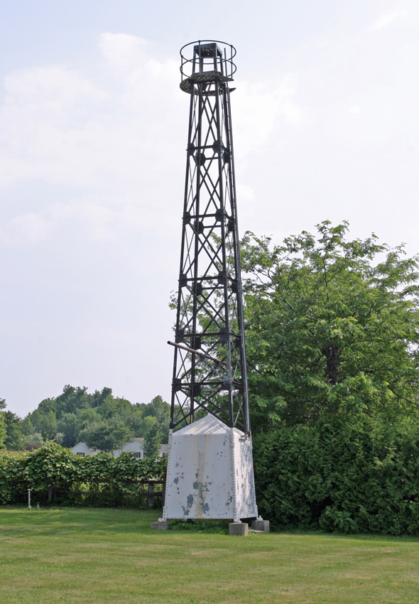
Skeletal tower that replaced Isle La Motte Lighthouse

