Pottawatomie (Rock Island), WI 


Select a photograph to view a photo gallery
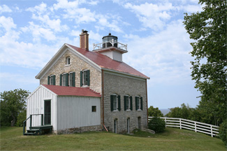


Photo Gallery

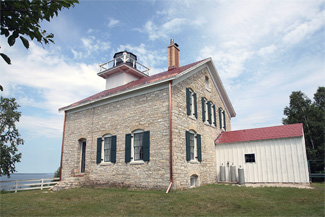
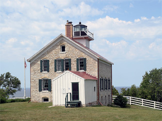
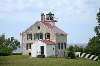
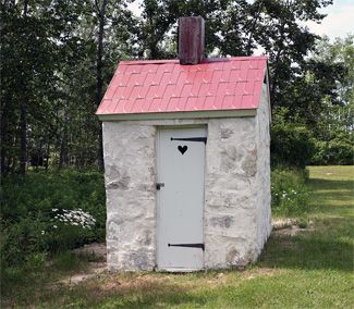
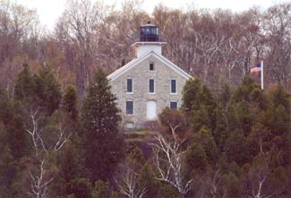
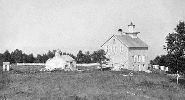

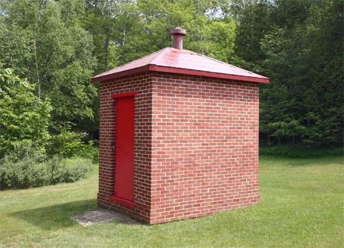
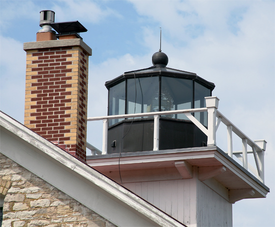

Photo Gallery
Photo Gallery
After a site was cleared atop the 137-foot bluff, rock was quarried a short distance to the south for use in the tower and dwelling. The tower, which tapered from a diameter of eighteen feet at its base to nine feet at its deck, was built thirty feet north of the dwelling. John Scott of Detroit was paid $474 to supply and install a light, based on the Winslow Patent and consisting of eleven lamps backed by fourteen-inch reflectors. On October 20, 1837, over a year after the lighthouse was to have been completed, Joseph Hobbs certified to the collector of customs at Mackinac that the material of which the lighthouse and dwelling are made, are of the best quality and that the work is done in a substantive and workmanlike manner.
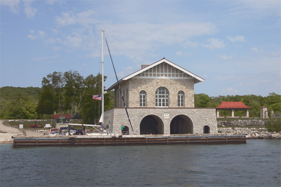
The lighthouse on Rock Island is known as Pottawatomie Lighthouse, after the Native Americans who had inhabited the area and whose name appropriately means keepers of the fire. Completed one year after the creation of the Territory of Wisconsin, Pottawatomie Lighthouse was the first lighthouse to be built on Lake Michigan in the present-day state of Wisconsin.
David E. Corbin, a veteran of the War of 1812 and a former fur trapper, was appointed first keeper of the light on December 19, 1837. In 1840, Keeper Corbin complained that plaster was falling off the dwelling, and an inspection report two years later noted that the buildings were very badly constructed, the mortar used not having the proper mixture of lime, permitting the water to ooze through it such as to keep the tower generally very damp.
An inspector in 1845 reported that Corbin was faithfully fulfilling his duties, but that being a bachelor, he was a bit lonely with his only companions being his faithful dog and Jock, his horse. Corbin was granted a twenty-day leave of absence on the condition that he return to the station with a wife. When the inspector visited the following year, he found that Corbin had been unsuccessful in his pursuit of a mate and seemed to be doomed to solitude during another dreary winter.
|
In 1858, a construction crew arrived on Rock Island to replace the earlier structures that were badly deteriorated. A basement was blasted out of the limestone cliff, and using local stone, a new two-story dwelling was built with a square wooden tower situated atop its northern gable. The tower was topped by a nine-sided lantern, which housed a fixed, fourth-order Fresnel lens that beamed forth its light at a focal plane of 159 feet.
William Betts, a Civil War veteran, was appointed keeper of Pottawatomie Lighthouse on March 22, 1870. Seventeen months later, the thirty-eight-year-old bachelor married sixteen-year-old Emily Rohn, daughter of Victor Rohn the keeper of nearby Pilot Island Lighthouse. An assistant keeper had been assigned to Rock Island starting in 1866, and when James Fuller resigned that position, Emily became her husbands assistant. This move let the family occupy the entire lighthouse, space they would soon need, as the first of William and Emilys nine children arrived in 1874.
Keepers Betts recorded important happenings such as storms and shipwrecks in the stations logbook. On January 20, 1876, Betts noted that two men attempting to row to the mainland from Washington Island never arrived after a terrible storm came up shortly after their departure. Betts felt the men had been carried out into Lake Michigan in the ice, and a subsequent entry made on May 3, 1876, confirms his suspicion was correct:
The two men who were lost last January have been seen several times once from Caney [Cana] Lt. House and once from Jacksonport. The men were apparently frozen stiff and sitting upright in the boat among a mass of ice At last account they were still adrift. There is not much hope now that they will be found and buried.
The Bettses would school their children at the lighthouse during the summer, but when the station was closed in the winter, the family would migrate to nearby Washington Island, where the children could attend public school.
Pottawatomie Light was converted from lard-oil to kerosene in 1880. For safety reasons, this more volatile fuel was typically kept in an oil house a short distance from the lighthouse, but due to a lack of funds, Rock Islands brick oil house was not built until 1904.
|
A telephone cable was laid to Pottawattomie Lighthouse in 1903. While the keepers enjoyed this modern convenience, they still had to haul some of their water by pail from Lake Michigan. In 1879, steps had been constructed leading down the bluff adjacent to the station to a new landing platform. This meant the keeper didnt have to walk over a mile to the landing at the southern end of the island for water, but procuring drinking water was still an arduous task. Finally, in 1909, a well was drilled near the lighthouse to provide a convenient water source.
On September 6, 1916, the steamer Peter Reiss, bound for Green Bay with a load of coal, ran aground on St. Martins Reef near the entrance to the bay. Keeper Edward Cornell and John Fitzgerald, his assistant, notified the Coast Guard and delivered messages to the stranded steamer. A tug and lighter were sent to remove some of the coal from the steamer so it could be freed from reef. As a result of the damage, the Peter Reiss had to spend two weeks in dry docks for repairs.
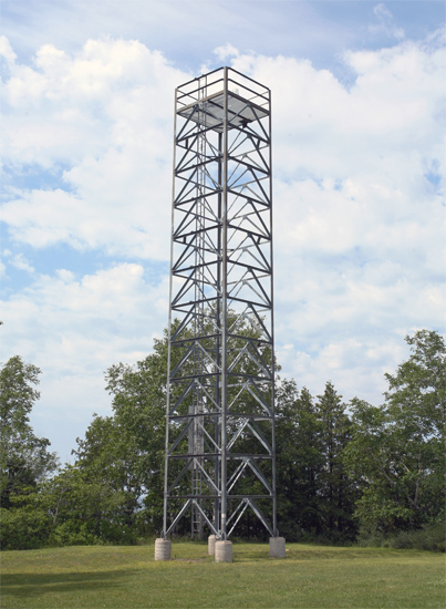
Ray H. Buttars served as head keeper of Pottawatomie Lighthouse from 1942 to 1946, and then Ernest R. Lockhart served as the last head keeper from 1946 to 1947, when wet-cell batteries were put in place to power the light and the dwelling was closed. Solar panels replaced the batteries in 1986, and two years later the Coast Guard installed a steel skeleton tower near the lighthouse to display the light.
Friends of Rock Island (FORI) State Park began working toward the restoration of Pottawatomie Lighthouse in 1994, and five years later, they succeeded in having a new lantern room installed atop the dwelling to replace the original one that had been removed by the Coast Guard. Tony Hodges, owner of Poverty Island, then a marine contracting company, just happened to visit Rock Island in 1997 and learn of the plan to restore the lighthouse. After contacting Tim Sweet, president of FORI, Hodges was given a contract to design and build the new lantern room.
After installing the lantern room, FORI raised funds to have a headstone, inscribed with an image of the original Pottawatomie Lighthouse, placed on Keeper David Corbins grave near the lighthouse in 2003. The following year, the lighthouse, restored to resemble the early 1900s, was dedicated on May 17 as the Pottawatomie Lighthouse Museum. In 2004, volunteer docents began living in the lighthouse for week-long stints from Memorial Day to Columbus Day while providing free tours to the public. To complete the restoration of the lighthouse, a replica fourth-order Fresnel lens was installed in the lantern room in May 2005.
In the 1880s, the Door County Advocate carried a report on an outing to visit the keeper on Rock Island by some young people from Washington Island. The party had brought baskets which were packed with the choicest viands, to which all did justice. It was one of the most agreeable days that has ever been spent on the island. Visitors to Pottawatomie Lighthouse today likewise find it an enjoyable and memorable destination for a day trip.
Keepers:
References


