Indian Island, ME 


Select a photograph to view a photo gallery
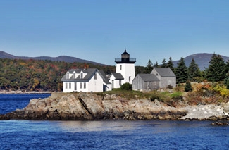


Photo Gallery

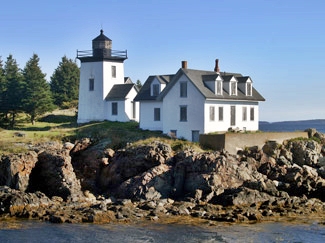
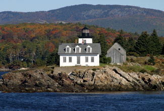

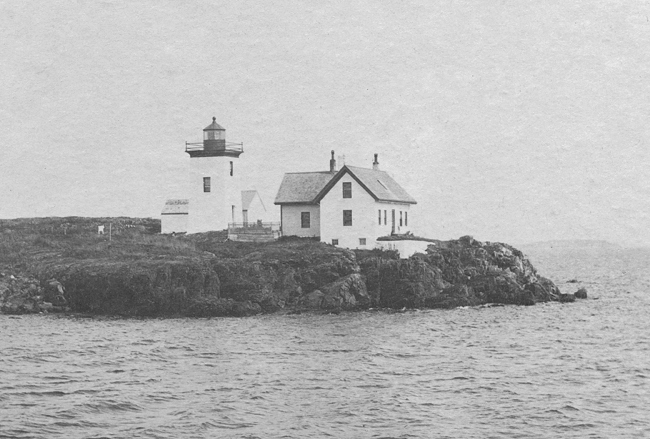

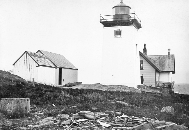
Photo Gallery
Photo Gallery
|
Customs Collectors in major ports also served as Lighthouse Superintendents, and Collector Luther Jewett provided the following recommendation for Rufus Dunning to serve as keeper of the soon-to-be-completed Indian Island Lighthouse:
As it is important to have good and worthy persons appointed to take charge of Light Houses and especially such persons, who make no use of ardent spirits as a drink, I would respectfully recommend the appointment of said Dunning and for these reasons: He never makes use of ardent spirits as a drinkHe has been long at sea and Knows by experience the value of a good lightHe is recommended by Ship Owners and Ship Masters, and has always sustained a good reputation
Despite this favorable endorsement, the appointment was given to David Sargent, who ended up serving only about a month as keeper. Silas Piper, his replacement, had sold the plot for the lighthouse to the government for twenty-five dollars.
Indian Islands first lighthouse consisted of a brick house with a lantern mounted on its roof. In 1856, a fourth-order Fresnel lens replaced the stations multiple lamps and reflectors. In November of the following year, the Lighthouse Board recommended that the lights at Prospect Harbor, Kennebunk Pier, and Indian Island be discontinued, with the following justification being given for discontinuing the light on Indian Island: Beauchamp Point light-house is situated two miles south of Negro Island light-house, in Penobscot bay. On account of its nearness to Negro Island light-house, it is of no use to the general navigation of the bay, and it is of but little use to the village near which it is situated, the commerce of which is small. Its discontinuance is respectfully recommended.
After Congress granted the Lighthouse Service authority to discontinue from time to time such lights as may become useless by reason of mutations of commerce and changes of channels of harbors, and other causes, Indian Island Light was discontinued in 1859 along with those at Prospect Harbor and Kennebunk.
Increasing shipments of lime from Rockport provided the grounds to reestablish the station, and Congress allocated $9,000 on June 23, 1874 to restore the station to working order. Upon an examination of the premises, the Lighthouse Board noted, it was decided to renew the wood-work of the old one-and-a-half story brick dwelling, repair the walls and foundation, increase the accommodations by a frame addition 16 feet square, and erect a brick light-house tower, the light having formerly been exhibited from a lantern on the roof of the dwelling.
|
Over the years, various repairs and improvements were made at Indian Island, including the following: the retaining wall in front of the dwelling was repaired and a new storm porch built over the dwellings back door in 1880, a house-pump and fifteen feet of lead pipe were furnished in 1883, a 150-foot-long boat slip was added in 1885, a wood house was erected in 1888, and a stone oil house was completed in 1904. In 1902, the power of the light was increased by exchanging the fifth-order Fresnel lens for a fourth-order lens.
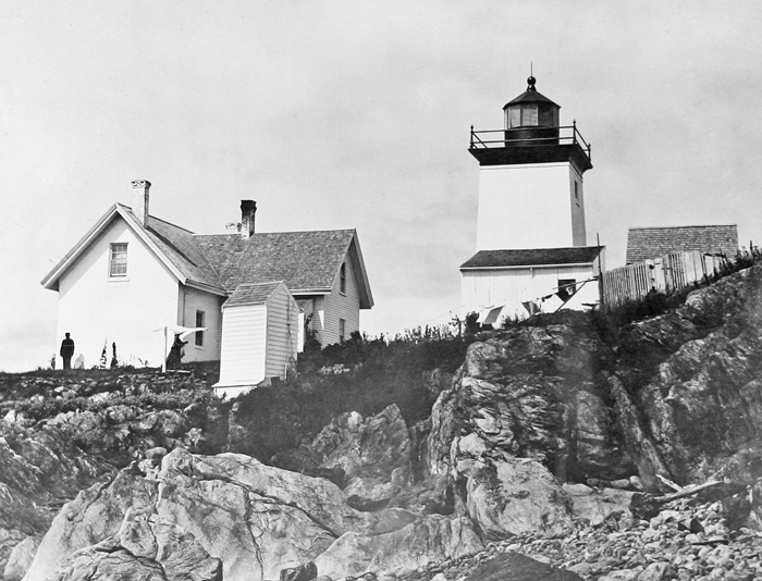
William Foster Reed, who had formerly been stationed at Saddleback Ledge, Halfway Rock, and the Cuckolds, served as keeper at Indian Island from 1925 to 1933. His granddaughter Barbara spent her weekends and holidays with her grandparents at the light and reminisced about her experiences there for a Lighthouse Digest article.
She recalled that the station was accessed by going to Beauchamp Point, cutting through Orchard Farm, then through some woods to the shore, where a long horn was kept to summon her grandparents on Indian Island. When Keeper Reed would hear the horn, he would row over from the island to fetch his granddaughter.
All of the furniture at the station belonged to Reed and his wife and had been transported there from the mainland. The heating system employed coal and wood that was also brought by boat. Once unloaded on the island, it had to be hauled to the house in wheelbarrows.
Unannounced inspections were performed by the Lighthouse Service, and everything, including the keepers dwelling, was held to high standards. At night, Barbara would often accompany her grandfather up the tower where the kerosene-fueled light often smoked up, requiring the glass to frequently be cleaned of soot. As the lime trade in Rockport slowed in the 1920s, Indian Island Light was considered of minimal importance and was passed over for renovation.
Barbaras grandmother baked bread, pies, and cookies. Also regularly on the menu were clams, fish, and lobsters, plus eggs and chickens, which were housed in a small outbuilding. Her grandfather also had a separate workshop.
In 1928, Keeper Reed provided the following description of his work at Indian Island:
This station consists of a seven-room house, light tower, oil house, boathouse, barn, woodshed, and other small buildings. My duty is to keep them in excellent condition at all times.In early spring, I clean, paint and varnish inside. As soon as the weather permits, I begin whitewahing and painting outside. The main house, tower, oil house and boathouse are whitewashed every year. The other buildings painted when necessary.
The lantern in tower has to be washed, and painted several times a year. The lens, brass and pedestal in lantern have to be polished weekly to keep them from tarnishing. All the tools have to be cleaned to keep them from rusting.
There is always more or less repairs to be made so that I can always find something to keep me busy most of the time the year round. At the end of each month, I send the Superintendent a report showing the condition of station and apparatus connected with it. I also send requisition for supplies needed for use at this station and an Annual Property Return of all articles received, expended and on hand at close of fiscal year. This statement shows a general routine of work at this station.
The light in the lantern has to be lighted at sunset and extinguished at sunrise every day in the year. It is my most important duty to see that the light is always burning.
In 1932, the Rockland Courier-Gazette printed a letter written by Foster Reed, that said the station was a quiet one without a telephone and little boat traffic in the winter. Someone goes to Rockport every day for the mail, and once in a while the Cornish or a large steamer is seen going up or down the bay. Foster Reed retired from the Lighthouse Service after Indian Island Lighthouse was discontinued on June 30, 1933, and he and his wife, Celia, moved to nearby Camden.
Barbara graduated from Camden High School in 1940. She visited her grandfather on graduation day, and later that night, Foster Reed passed away, his job of helping raise his granddaughter to adulthood complete.
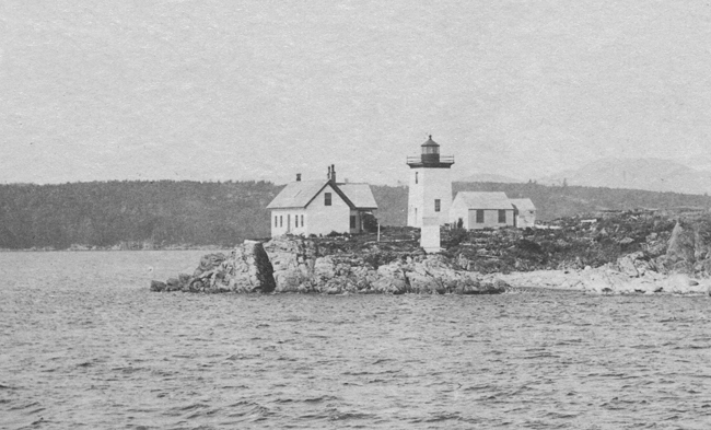
In August 1934, articles in various newspapers announced that nine Maine lighthouses, abandoned during the national economy program, were being sold by the U.S. Lighthouse Service. These lighthouses included those at Pumpkin Island, Hendricks Head, Winter Harbor, Grindle Point, Indian Island, Tenants Harbor, Narraguagus, Isle au Haut, and Doubling Point. Indian Island Lighthouse was sold at auction for $1,025 to William L. Pattison of Chicago in September 1934. The island and lighthouse have remained in the same family ever since. An automated light was established on Lowell Rock, just off Indian Island, in 1949.
Head Keepers: David Sargeant (1850), Silas Piper (1850 1853), William McLaughlin (1853 1857), Richard Grinnell (1857 1859), Joseph Small (1875 1881), Knott C. Perry (1881 1894), David S. Arey (1894 1902), Edmund Coffin (1902 1914), Charles E.B. Stanley (1914 1921), Leroy S. Elwell (1921 1925), William Foster Reed (1925 1933).
References
