Fort Point, ME 

Select a photograph to view a photo gallery


Photo Gallery
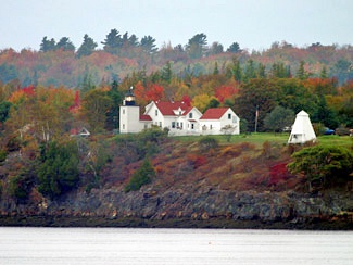
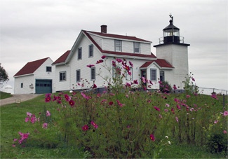
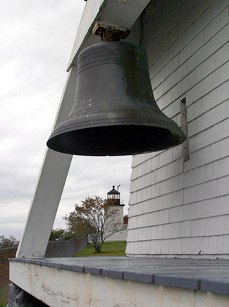


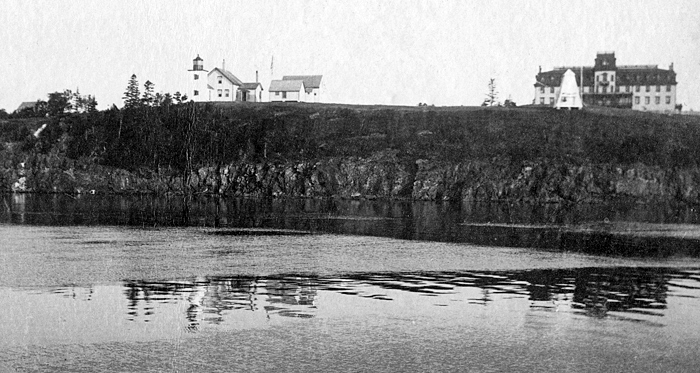
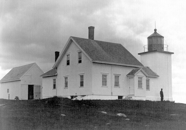
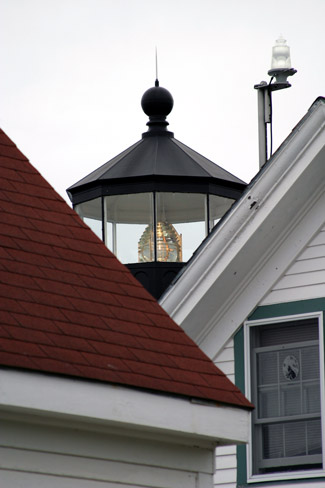
Photo Gallery
Photo Gallery
|
In 1758, Thomas Pownall, Governor of the Massachusetts Colony, which then included Maine, wrote to William Pitt, Prime Minister of England, extolling the advantages of an outpost on the Penobscot River.
A fort at Penobscot River would be of the utmost importance. It would put the British right, out of a dispute. It would take possession of this very fine country, which the Indians never dispute when done in war. It would effectually drive off the remains of the Noridgwoak and Penobscot Indians as it would break up their Hunting and Fishing. It would take possession of the very finest bay in North America
The following year, Governor Pownall led four hundred men north, where he selected Wassaumkeag Point as the site for the fortification, before returning to Boston around the end of May. It took just over a month for the men to complete the fort, which was named in honor of the governor. The presence of the fort spurred development of the surrounding country, and it remained occupied until the British removed its cannons and powder in 1775. Americans later burned the blockhouse and filled in the ditch surrounding the fort to prevent the British from using the fort to their advantage.
On June 30, 1834, Congress appropriated $5,000 to enable the Secretary of the Treasury to provide, by contract, for building a light-house on a proper site on Fort Point, at the entrance of Penobscot Bay, in the State of Maine. The lighthouse, a conical tower built of undressed split granite and an accompany dwelling were completed for just over $4,377. The tower was topped by an octagonal iron lantern housing eight lamps with thirteen-inch reflectors that shone a fixed white light at a height of ninety-nine feet above high water.
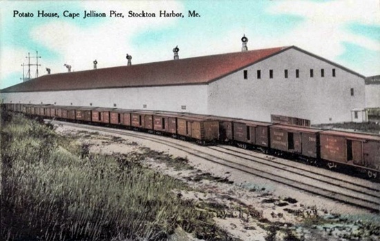
Located near the town of Stockton Springs, Fort Point Lighthouse went into service to guide ships hauling literally tons of potatoes and timber from the area. Between 1905 and 1907, three long wooden piers were built that turned Cape Jellison into a bustling port. A huge 600-foot-long warehouse, capable of holding 240,000 barrels or an astounding 18 million pounds of potatoes grown in Aroostook County, was situated near the wharves. A fire in 1924 destroyed the wharves, and the port never recovered.
Fort Point Lighthouse was built on land sold to the government by its first keeper, William Clewley. Initially, Clewley must have been pleased to move into the new one-and-a-half-story, twenty by thirty-four-foot keepers house with its attached kitchen. However, a mere six years later, Inspector I.W.P. Lewis said the dwellings walls were cracked on all four sides and the towers walls were cracked from roof to base. The lantern deck atop the tower was loose and leaky, and the interior walls froze over during the winter. Keeper Clewley provided the following statement on the condition of his residence:My dwelling-house is very much out of repair. The walls are of stone, and, owing to defective building, have cracked on all four sides, so much as to cause continued leakage in wet weather. The roof also leaks so much that we are obliged to take up carpets and swab the floors. I swabbed up twelve buckets of water off the floor of the sitting room. The cellar way walls have been thrown by the frost, and will fall down unless rebuilt.
When Levi Bowdin took over after Clewley in April 1850, the problems still had not been corrected. It was not until 1855, when John Odom was keeper, that the Lighthouse Board finally conceded the station was entirely worn out and requested $5,000 from Congress to rebuild it.
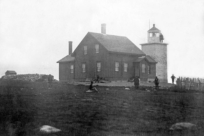
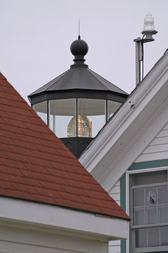
Two years later, workmen completed a new lighthouse, a thirty-one-foot-tall square brick tower, equipped with a fourth-order Fresnel lens and attached to a two-story, wooden keepers dwelling.
In 1872, a new luxury hotel named Wassaumkeag (birthplace of seals) crowned the top of the cliff, fifty feet north of the lighthouse. Not surprisingly, that same year Maine passed a law prohibiting the killing of seals within two miles of the hotel. The opulent resort was described in 1875 as having 125 rooms, billiards, bowling, steam-heating, salt and fresh baths, a telegraph office, broad verandas, and a promenade roof that offered commanding views of Penobscot Bay and the distant peaks of Mount Desert Island. Visitors to the hotel were invited to travel and walk over the grounds of the light station, which resulted in a lighthouse inspector calling for fencing to maintain the keepers privacy. In 1883, a portion of the lighthouse grounds was enclosed with some nine hundred feet of wire and one thousand feet of picket fencing, and some minor repairs were made.
The money-losing hotel went through three name changes and four owners before 1898, when on June 7 of that year, the keeper reported, Alarm was given at 10 pm, that the Fort Point Hotel was on fire. The building fell at 10 minutes of 11 pm. It was totally destroyed.
From 1866 1882, Fort Points keeper was Civil War veteran Hiram Grant, followed by Adelbert Webster (1882 1902), John Thurston (1902 1919), Edward Farren (1919 1929), and Arthur B .Mitchell (1929 1950), former captain of the George W. Collins, a two-masted schooner.
|
In 1950, the first Coast Guard-employed keeper, Ernest Mathie, stepped in to care for the light. BM1 Larry Baum was the last keeper when the Coast Guard automated the station in October 1988. Keeper Baum said, It has been an exciting place for the kids; some children have truck drivers or train engineers to wave at, my kids have ships.
Fort Point Lighthouse remains an active guide to navigation and is one of nine lighthouses in Maine still using a historic Fresnel Lens. The lighthouse was leased to the Maine State Bureau of Parks and Land by the Coast Guard in 1989 and has since served as housing for a park supervisor. Terry Cole was thrilled to accept the position of park supervisor and return to the station where he once served as keeper. The Coles have lived a total of over thirty years at the lighthouse now far longer than anyone else.
The stations pyramidal wooden bell tower, one of the few left in New England, is listed on the National Register of Historic Places. Under the Maine Lights Program, the deed to the lighthouse was transferred to the State of Maine in 1998.
Head Keepers: William Clewley (1836 1850), Levi Bowden (1850 1853), John Odom (1853 1861), Henry S. Stowell (1861 1866), John J. Bowen (1866), Hiram J. Grant (1866 1882), Adelbert G. Webster (1882 1902), John B. Thurston (1902 1919), Edward S. Farren (1919 1929), Arthur B. Mitchell (1929 1950), Ernest H. Mathie (1950 1957), Ernest DeRaps (1957 1959), Robert R. Kinney (1959 1960), Wayne McGraw ( 1962), Boyd J. Davis (1962 1964), James H. Perry (1964 1966), Raymond W. Scarborough (1966 1968), Eugene R. Benner (1968 at least 1970), Harry Lahaye, Terry Cole (1973 1976), Paul Munroe (1976 1979), Harold W. Smith (1979 1980), Alan D. Achorn (1980 1984), Larry Baum (1984 1988).
References


