Bear Island, ME 


Select a photograph to view a photo gallery


Photo Gallery
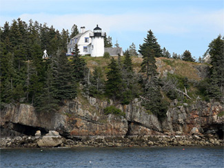
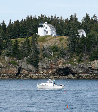
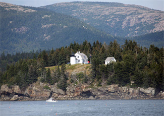
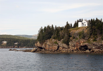
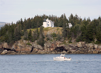

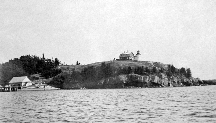
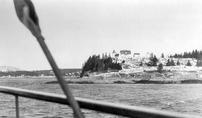
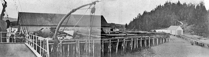
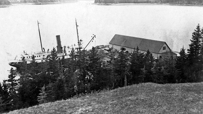

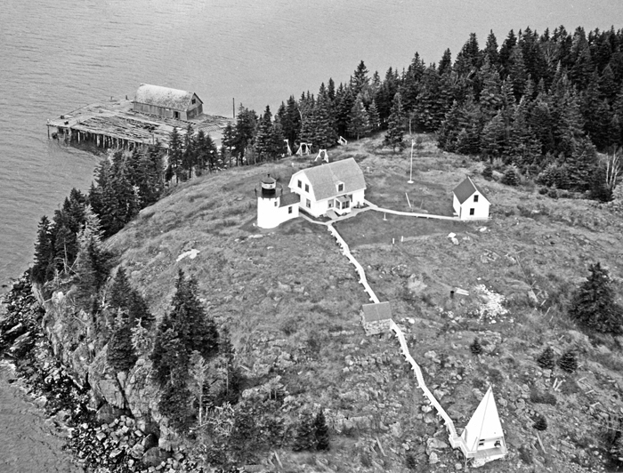


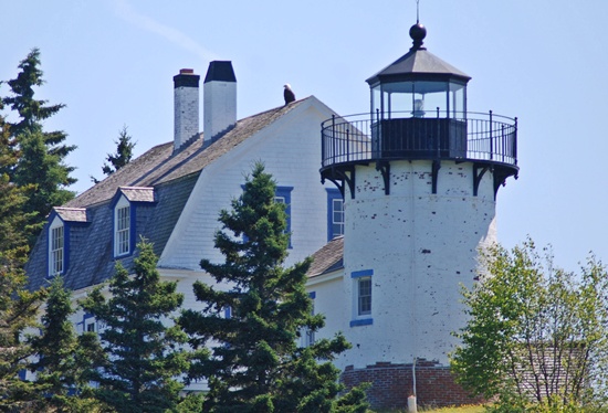

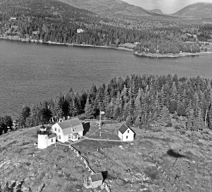
Photo Gallery
Photo Gallery
|
There is no place where there is a light so much required, on or about the island of Mount Desert, as on a small island, called Bear isle, at the entrance of Northeast and Southwest harbors; these harbors are much frequented by vessels employed in foreign and domestic trade; I have frequently seen from three to four hundred sail of vessels at a time in these harbors.Vessels from Europe or the West Indies, bound on this coast, generally make Mount Desert hills the first land; they then make Bakers island light; if to the westward, they will stand to the eastward until they open the light on Bear island, then run for it, the course being northwest by west.
Captain Smith learned that the owner of the island, William Moore, demanded $500 for the eleven-acre island or $50 for two acres on its western side, even though he had purchased the island for $101.17 just a few months earlier.
Following President Martin Van Burens approval, the light was built in 1839, using a $3,000 appropriation granted on July 7, 1838. Spurling Point on Great Cranberry Island had originally been examined and rejected for the light.
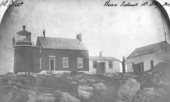
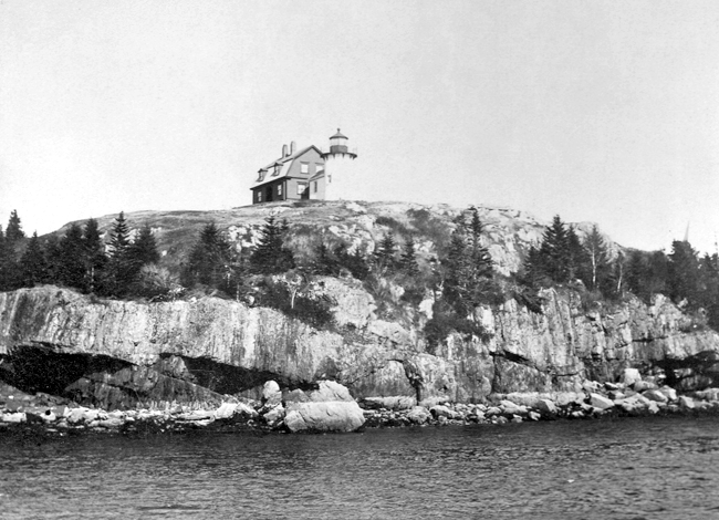
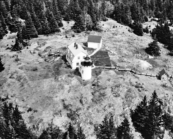
Bear Island was from the beginning a family station with a single keeper. The original lighthouse consisted of a wooden tower set atop the southern gable of a granite rubblestone keepers house. The dwelling had three rooms on the first floor, two chambers in an attic, and a cellar beneath it that held two wooden rainwater cisterns. The towers octagonal lantern room housed seven lamps and thirteen-inch reflectors, which produced a fixed white light at a focal plane of ninety-eight feet above the surrounding water.
According to The Island of Mount Desert Register with the Cranberry Isles 1909-10, William Moore, who sold a parcel on his island to the government, went from keeping sheep on Bear Island to being the first lighthouse keeper there. Other sources list John G. Bowen as the first to tend the light. Whether or not Bowen was the first, he definitely served as keeper, because when Secretary of Treasury Walker Forward dismissed him in 1842, he sent a letter to a Maine congressman about it. Interference in elections, both under the late and present administrations, and absence from the lighthouse for days in succession are the principal charges against Mr. Bowen, wrote Forward. The election interference allegation was almost as serious as leaving the light untended, given that lighthouse positions were political appointments.
|
Captain Whitcomb, of the cutter Alert, felt Bear Island Light could be dispensed with altogether, but a local customs collector disagreed, citing the experience of Captain Doyle, who in a recent voyage from Eastport would have lost his vessel and its valuable cargo if it had not been for the light.
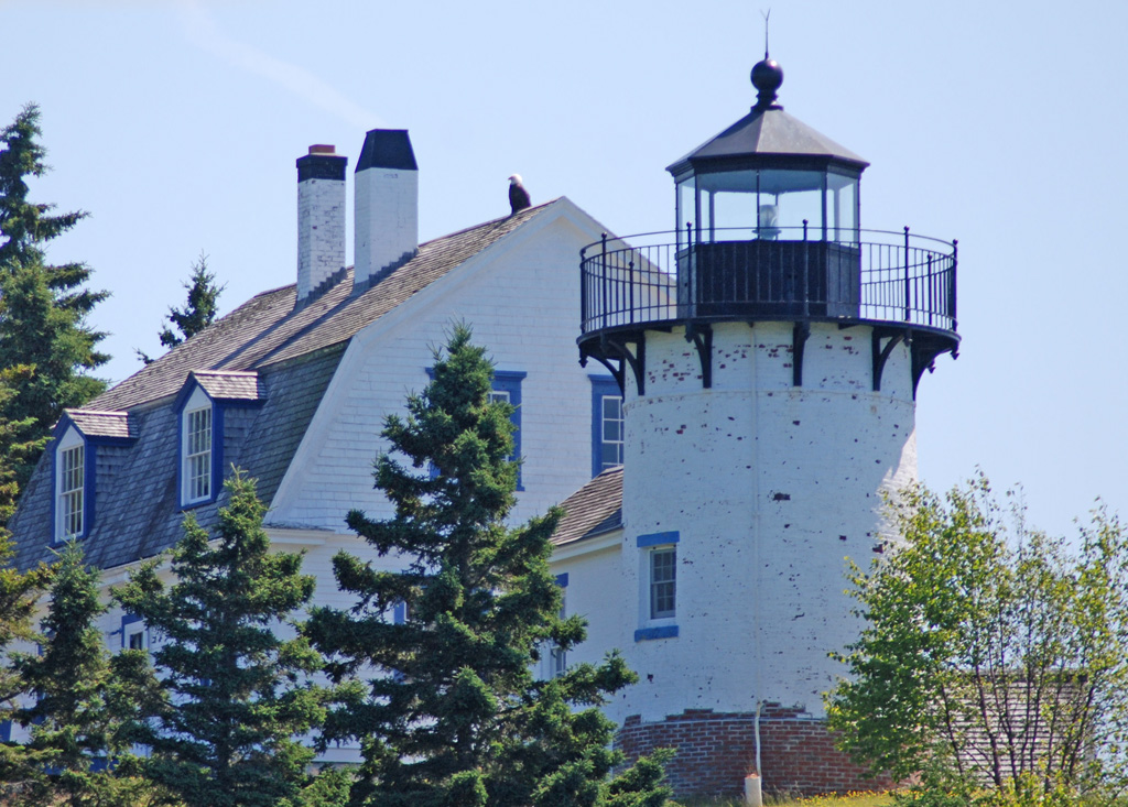
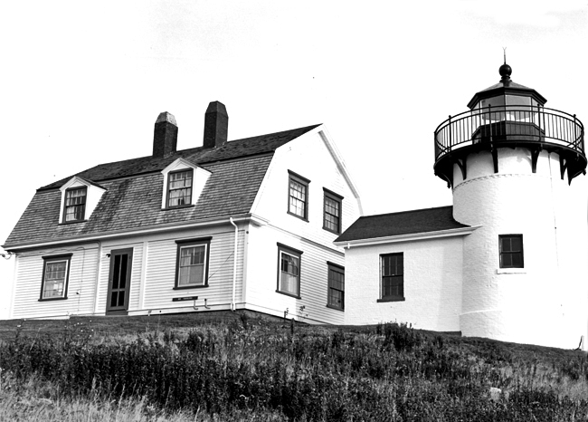
Bear Island Lighthouse was severely damaged by fire in 1852 and rebuilt in 1853, probably reusing many of the original materials. As experience proved that the original design put too much stress on the dwellings roof, the new construction featured a thirty-one-foot-tall, cylindrical brick tower placed at the southern end of the dwelling. A few years later, in 1856, a fifth-order Fresnel lens replaced the stations old lighting apparatus.
Despite previous criticism about John Bowen, he wangled his return to Bear Island for not just one but three more stints as keeper. Local politician Charles Peters was but one who cried out for his removal. Peters wrote to a justice of the peace: Washington needs to know what kind of a critter Bowan has been .if he has been known to attend political conventions if he has been an active and brawling Partizan .I want to sluice Bowan before he knows it. After enough prominent Whigs signed a petition, Bowen was again given the boot, but the resilient Bowen was appointed keeper again in 1853 and served for two more years.
Bowens successor in 1855 was Caleb S. Goold. It is not known for certain how many children Goold had, but together with one other family, Bear Island was designated a separate school district under Goolds direction. The school district lasted until 1871, when William Fennelly was keeper, and was reestablished in 1880 when Keeper Stephen Smallidges family had five children.
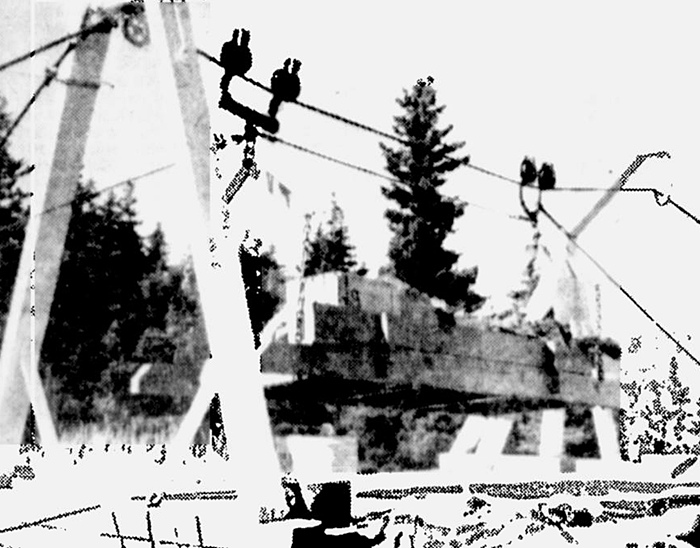
In 1885, a 170-foot-long crib wharf with twelve feet of water at its outer end at low tide was erected to facilitated landings at the island. Two years later, a bell tower was built atop the island, and a thirty by sixty-foot coal-shed, with a capacity of 390 tons, was added to the wharf. The coal-shed and wharf, which was greatly expanded in 1892, served as a supply depot for the areas buoy tenders until 1934, when a new depot was built at Southwest Harbor. An aerial tramway was used to haul supplies from the wharf to the top of the island.
A 1,000-pound bell, struck by machinery, was housed in the bell tower. Terry Stanley, a Coast Guard keeper on the island in 1959, said the apparatus worked like a Swiss clock. You cranked weights up to the top of the tower and it would ring the bell every so many minutes.
Before the fog bell was added, Bear Island was home to a Newfoundland dog, which according to a newspaper account in 1875 would begin to bark when he heard the paddlewheels of an approaching steamer. This proved to be of great advantage in foggy weather. When the dog heard the ships engineer give a salute with three whistles, he would stop barking and trot off with great satisfaction.
|
In the 1930s, Keeper Elmo J. Turner transferred to Bear Island from Great Duck Island Light. His granddaughter, Joyce MacIlroy, would visit her grandparents at Bear Island station where they kept chickens and a cow. There was no power on the island, said Joyce, so my great grandmother would keep the fresh cream in the cellar. One day, the cow had to be taken to the mainland, so Elmo loaded her into the dory and rowed her across to Northeast Harbor, then rowed her back over to the island. The cow got seasick on the way back that must have been quite the sight!
Bear Island Lighthouse passed to the U.S. Coast Guard in 1939 but remained a family light.
Nancy Lang was living with her parents in Rochester, New York and had been working for Hickok Manufacturing Company for eight years, when a friend named Dot asked Nancy to write to her cousin David Sparks, who as a lighthouse keeper on Mount Desert Island. Nancy started writing to Dave, and not long thereafter he sent her a copy of a newspaper article that carried the following on his station: The writer hopes that you who read this may give more than a passing thought to these brave men who sacrifice home and safety to keep others safe stationed on this loneliest of outposts when winter storms bring 70 mile[-per-hour] gales that pile seas high against the Rock and every time they break it could the last of both station and keepers.
After reading the newspaper article, Nancy couldnt stop thinking about Dave, and faithfully wrote him a lengthy letter every day. Her letters often piled up at the mainland post office before a boat could take them to the island, and Dave would razz the other keepers by saying: You count your letters. Ill weigh mine.
On his next leave, Dave traveled to Rochester unannounced, and, according to Nancy, It only took a day for us to know we were meant for each other. The article Dave sent Nancy was dated January 1957, and he arrived in Rochester on February 13, 1957. They were engaged that Easter and then married in Nancys neighborhood church on September 21, 1957. Two months after the wedding, Dave was transferred to Bear Island Lighthouse, where Nancy was able to join him.
Nancy had been warned that the station didnt have commercial power, but she was still pleased with her new lighthouse home. A gasoline generator supplied power for pumping water and running their inside lights, television set, washer, and iron. The kitchen had a stove and refrigerator that ran on propane, and a coal furnace provided heat and hot water.
Just weeks after he arrived on Bear Island, Dave tripped on a small can of fuel when opening the door to the furnace room, and the fumes exploded into a flash-fire. While the lighthouse was not damaged, Dave received first and second degree burns on his face, arms, and hands. A Coast Guard vessel rushed the couple from the island to Southwest Harbor, from where they were taken to the hospital. Dave was hospitalized for a week, and a white stocking was placed over his head to hold his bandages in place, earning him the nickname Casper, the Ghost. As it was the Christmas season, the nurses affixed a bow and some jingle bells to the stockings knot on top of Daves head.
|
Steve Loiver, one of the last Coast Guard keepers of Bear Island Lighthouse, was concerned about the move to automate the light. Said he, I just hope that in the need to economize we dont destroy the things that give flavor and uniqueness to life. Besides, an automated light cant save or assist people as Keeper Heber G. Sawyer did. In 1914, 1916, 1918, and 1921, he used his personal boat to rescue people aboard disabled craft.
Bear Island Lighthouse slowly began to deteriorate after 1981, when the light was deactivated and replaced by two lighted bell buoys anchored offshore. The National Park Service gained ownership of the station in 1987, and not long thereafter, the Friends of Acadia resurrected the lighthouse and relit it in 1989 as a private aid to navigation, exhibiting a white flash every five seconds. After the lighthouse was listed on the National Register of Historic Places in 1988, the Park Service was allowed to lease the property.
Martin Morad, a professor of pharmacology and medicine at Georgetown University who first saw Bear Island Lighthouse in 1971 and had subsequently tried to purchase or lease the property, was the first lucky private citizen to call the lighthouse home. Morad and his wife Fabiola Martens, a lawyer turned interior designer, spent a few years and a lot of money restoring the lighthouse before using it as a summer vacation cottage.
The house had been boarded up for so many years that the humidity from the water in the cisterns permeated the entire place, Martens recalls. At every inspection the lighthouse keepers added another layer of paint, without ever removing any of the old paint. Over the years the dampness caused the eleven layers to crumble and form stalactites and stalagmites. It was as if one was entering a grotto! The stations water problem was solved by running an underwater pipeline to Northeast Harbor. Later, electricity was brought in, and a sewer system was installed.
The couple found little need to hang paintings in the house, as the views from each window offered an ever-changing picture. Our primary goal, Martens remembers, was to respect the essential simplicity of the lighthouse.
Bear Island Lighthouse is not open to the public. It is best seen from the water, with cruises past the island being offered most days during the summer.
Head Keepers: John G. Bowen (1839 1842), Solomon L. Howes (1842 1844), John G. Bowen (1844 1850), Levi Robinson (1850), John G. Bowen (1850 1851), Levi Robinson (1851 1853), John G. Bowen (1853 1855), Caleb L. Gould (1855 1857), William Moore (1857 1861), Seth Hopkins (1861 1865), Alfred Emory (1865 1869), William Fennelly (1869 1874), Stephen Smallidge (1874 1883), Alden H. Jordan (1883 1899), Lewis F. Sawyer (1899 1912), Heber G. Sawyer (1912 1924), Elmo J. Turner (1924 1929), Earle E. Benson (1929 1930), Elmo J. Turner (1930 1936), Andrew H. Kennedy (1936 1946), Harry B. Dobbins (1947 1952), Carroll Alley (1952 1955), George E. Tetreault (at least 1956 1957), Bill Andrews (1957), David L. Sparks (1957 1959), Terry Stanley (1959 1960), Edward Leighton (1960 1961), Wyndell K. Fordham (1961 1964), Clifton F. Olsen, Sr. (1964 1965), Larry E. Conley (1965 1968), Burleigh A. Chandler (1968 1969), David C. Holmes (1969), Frederick M. Coyle (1969 at least 1970), Stephen Cancellare (1976 1978), Steve Oliver (1978 1980), Guy Veillette (1980 1981).
References


