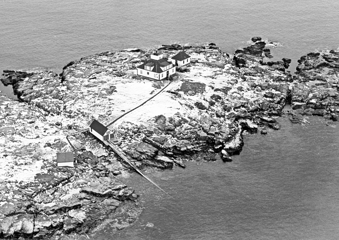
Egg Rock, ME 
Select a photograph to view a photo gallery
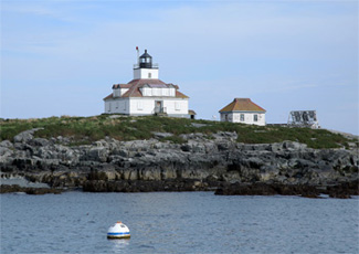


Photo Gallery

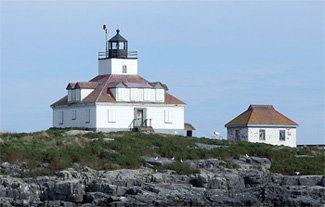
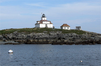
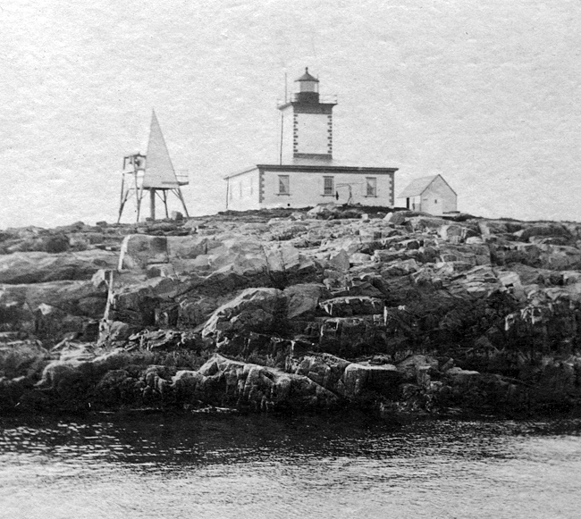

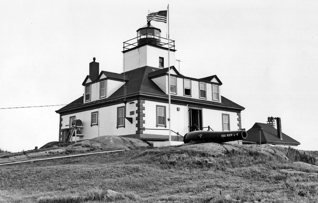


Photo Gallery
Photo Gallery
On June 23, 1874, Congress appropriated $15,000 for a light-house and fog signal at or in vicinity of Egg Rock due to increasing seasonal ferry traffic. Difficulties in obtaining title to the island delayed construction until June 1875. The Lighthouse Board noted that landing material at the site was problematic and similar to the situation faced at Avery Rock, where a lighthouse using identical plans was under construction. By July 1, 1875, the foundation for the lighthouse had been laid on Egg Rock, the brickwork was nearly finished, and the ironwork was completed and ready to be set in place, but the station would not be put into operation until November 1, 1875. The tower held a fifth-order Fresnel lens that exhibited a fixed red light tended by Egg Rocks first keepera twice-wounded Civil War veteran name named Ambrose H. Wasgatt, who remained at the light for about ten years.
Just a few months after it was activated, the exposed lighthouse experienced the first of many tests Mother Nature would send its way as recorded in the Annual Report of the Lighthouse Board: During a gale on the 21st of March, 1876, the sea washed over the rock, carrying away the fuel shed and moving the bell tower some 30 feet. The windows of the dwelling were broken in on the sea-side, and the dwelling flooded to such an extent that the oilbutts were moved from their benches. Amaziah R. Small, who succeeded Wasgatt as keeper, was at the light in 1887, when a gale swept across the island carrying off the outhouse, hen house, and everything moveable. Keeper Heber Sawyer wrote of two similar storms in 1900. A gale on February 1, 1908 was strong enough to move rocks on the island weighing up to thirty tons.
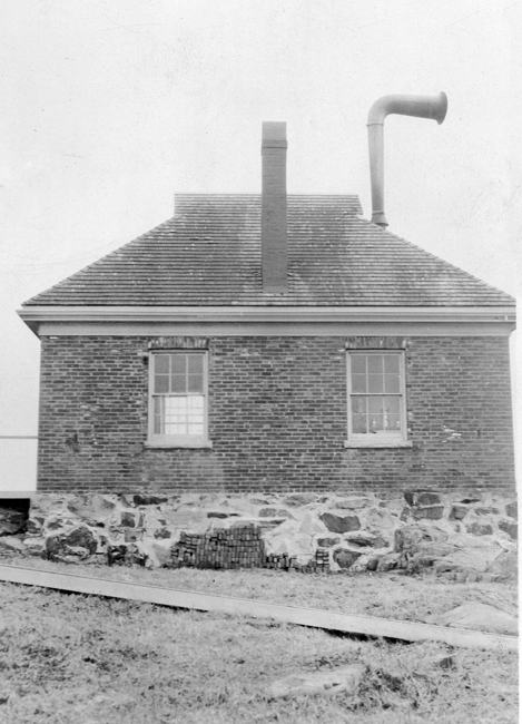
Unfortunately, the placement of the dwelling around the central tower made the dispersed rooms nearly impossible to heat during Maines long, harsh winters. In 1899, $1,700 was requested for a second floor that would provide a sufficient number of rooms for a second family and make the dwelling easier to heat. This renovation gave the station its current roofline with its numerous dormers, and made room for an assistant keeper, who was added to the station in 1898.
In 1901, the fifth-order Fresnel lens was upgraded to a more powerful fourth-order lens that changed the lights characteristic from fixed red to a white flash every five seconds. Problems with the rotating mechanism caused the lens to stop periodically, which cracked some of its prisms.
|
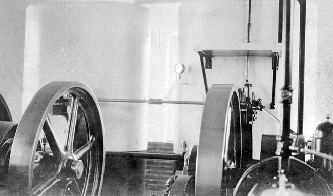
One of the areas most famous summer residents was Joseph Pulitzer of newspaper fame, whose family established the Pulitzer Prize in his honor. In 1894, he purchased a twenty-seven-room summer house called Chatwold, in Bar Harbor, four miles from Egg Rock. Pulitzer began extensive renovations, and before long the house totaled over fifty rooms. Pulitzers extreme sensitivity to noise prompted him to spend over $100,000 to build what was pronounced the Tower of Silence by family and staff. Pulitzers bedroom was located at the top of a tower and featured a floor resting on ball bearings, double glazed windows, and walls insulated with steel wool. Still, Egg Rocks fog signal plagued him. In June 1904, the islands fog signal was changed from a bell to a first-class Daboll trumpet, powered by a four-horsepower oil engine, air compressor, and air tank, in duplicate. The upgrade was at least partially in response to the grounding of the Massachusetts battleship on a ledge off Egg Rock the previous year. In 1905, the fog signal sounded 1,119 hours (using 571 gallons of oil); in 1906, it sounded 1,351 hours (requiring 539 gallons of oil); and in 1907, 1,813 hours (762 consuming gallons of oil). Even though Pulitzer had an indoor pool that was ocean fed and steam heated, he couldnt block the moan of the fog horn; and it made him furious.
Complaints by Pulitzer and other residents led Maines Senator Eugene Hale to send a telegram to the Lighthouse Board. An official responded in July 1904, with an apparent brush-off: There is much truth in the story from Bar Harbor and some exaggeration. This fog horn is simply carrying out the mandates of Congress .This conflict between shore dwellers and the mariners has always been with us, and is one of the most difficult situations the department has to face. As the board is created, however, to give protection to the mariner, his interests are to be conserved first, and the summer cottagers who live two months in the year in the vicinity of the station will be given such consideration as is proper. But the issue didnt die there. Rear Adm. Robley D. Evans, chairman of the Lighthouse Board, arrived in Maine to personally assess the situation. By 1905, the axis of the trumpet was changed to approximately magnetic south, away from Bar Harbor, reducing the noise onshore.
|
One freezing cold day in March 1935, he said goodbye to his family and set off in a skiff to visit Arthur Stover, caretaker at the Hawkes summer estate at Schooner Head who had purchased some radio batteries for him. Keeper Pinkham had tried to convince Buster to take the stations peapod, but Buster insisted on going in his punt. Pinkham kept an eye on Buster as he made the two-mile trek to Schooner Head. When he just over half way, Pinkham could tell through the spy glasses that something had happened, and he rushed down to the boathouse and launched the peapod. Pinkham made the best time possible using oars, but when he reached Busters overturned punt, there was no sign of his assistant, except for his cap that was floating on the water. Pinkham hunted for any trace of Buster, but finally had to abandon the search and return to the station to activate the light. The Coast Guard searched for Busters body for a few days, but it wouldnt be found until July 1935, when the crew of the trawler Eliza C. Riggs out of Gloucester picked up the body in its drag between Cat Island and Egg Rock Lighthouse.
Three weeks after Busters death, his third baby boy was born. Dalzells wife never remarried, saying that no one could replace her husband. The boat Buster had lovingly made was sold to help support their three children on the meager survivors pension from the Lighthouse Service.
Other Egg Rock keepers included Augustus B. Hamor (1913 1930), best known for his time at Owls Head Light, where his dog Spots insistent barking reportedly saved the mail boat from crashing during thick fog; Jaruel B. Pinkham (1921 1942, when he applied for disability retirement); and Captain Thomas L. Keene (mid-1940s) formerly of the U.S. Coast Guard lighthouse tender CG-80004, which brought supplies to Maines lighthouses. Keene was also a prolific writer and poet, primarily occupied with themes about lighthouses and life at sea.
During automation in 1976, the Coast Guard removed the lantern room from the tower to make room for a rotating aero-beacon and created what many called the ugliest lighthouse in Maine. It received so many complaints that in 1986, the Coast Guard built an aluminum lantern room to house a modern optic, powered by an underwater cable from Mount Desert (pronounced Dessert) Island. By 1999, the station had been converted to solar power for the light and the fog signal, and the cable was abandoned. To prevent birds from landing on the solar collectors and dirtying them, they were equipped with humane, bird repelling spikes.
Egg Rock was one of several islands named for the bounty of eggs that could be collected there. Though seabirds abandoned Egg Rock after the lighthouse was established, in 1998, the islands lighthouse was one of seven transferred to the U.S. Fish & Wildlife Service for the protection of nesting birds.
In 2009, the U.S. Fish & Wildlife Service was able to use federal funds for economic stimulus to provide materials for a community-led repair mission. As one of the most-viewed lights in Maine, it attracted the attention of residents and area businesses that donated time, money, and materials to help the project. Egg Rock Lighthouse remains an active aid to navigation.
Keepers:
References

