Prospect Harbor, ME 

Select a photograph to view a photo gallery
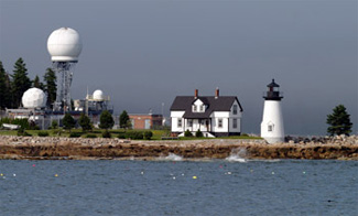
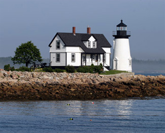
Photo Gallery


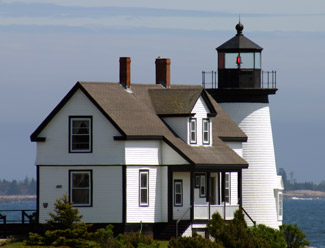

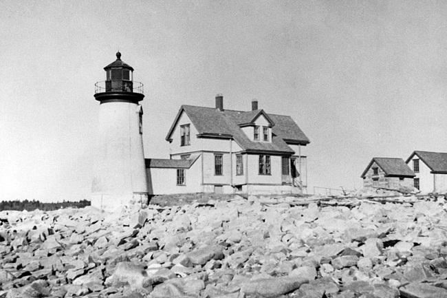
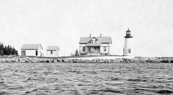
Photo Gallery
Photo Gallery
|
The original lighthouse took the form of a granite conical tower attached to a one-and-a-half-story granite keepers dwelling. Samuel H. Sargent replaced Nathaniel Noyes, the first person appointed keeper of the lighthouse, in March 1849.
In 1856, the tower was fitted with a new and improved reflecting apparatus, which served until a fifth-order Fresnel lens was installed in the lantern room the following year, changing the lights characteristic from fixed white to a white flash every sixty seconds. Congress decided to discontinue Prospect Harbor Light in 1859 after being informed that the harbor was not used as a harbor of refuge and the nearby village had only a little coasting trade, which did not justify the maintenance of the light.
This decision was reversed roughly a decade later, and the light was re-established to serve as a guide to the harbor of refuge which it marks. The existing tower, lantern room, and keepers dwelling were thoroughly renovated and repaired and a few new out-buildings put in place. The Lighthouse Board published the following to announce the reestablishment of the light:
Notice is hereby given that a revolving light, alternating with red and white flashes, at intervals of thirty seconds between the flashes, will be exhibited on May 15, 1870, and on each succeeding evening, from sunset to sunrise, from the old lighthouse tower at Prospect Harbor, Maine.The height of the tower, form base to lantern, is 30 feet, and the height of the light above the mean level of the sea is 45 feet.
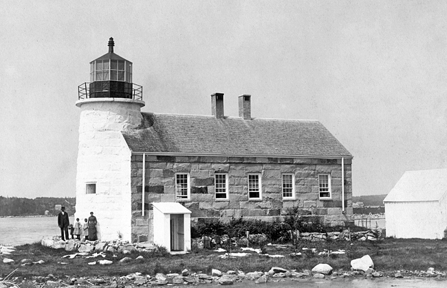
This tower is on Prospect Harbor Point, Goldsborough, Maine, on the eastern side of the entrance to the harbor. It is built of granite, whitewashed, is connected with and stands at the southerly end of the keepers dwelling, which is a one story granite building.
Despite extensive repairs to the tower and house in 1881, by 1889, the stone dwelling and tower were in poor condition. A wood-frame house, built on the same foundation of its successor, and a separate brick tower with iron deck and lantern were recommended at an estimated cost of $3,500 for the dwelling and $2,750 for the tower. On July 25, 1891, the light was moved to a conical, wooden tower, thirty-eight feet tall, that was built about twenty-five feet south of the granite lighthouse. Around that same time, a frame dwelling 19 by 20 feet in plan, with ells each measuring 12 by 16 feet was built on the foundation of the old stone dwelling. A barn 16 by 28 feet in plan was built to replace the old barn. A brick cistern was built in the cellar and the cellar floor was raised 2 feet to exclude water. The ground around the dwelling was graded to prevent the accumulation of water. A boathouse and boat slip were added in 1897.
|
Ambrose Wasgatt, a veteran of the Civil War, took over as keeper in 1891. His two daughters had fond memories of playing croquet on the lawn with guests and enjoying boathouse dinners where tables full of food were put out for visitors. Ambrose Wasgatt retired in 1918, after thirty-three years at the lighthouse, and William C. Gott was placed in charge of the light.
Albion Faulkingham, the lights last keeper, served from 1930 until the light was automated in 1934. John Workman took over as a caretaker of the property shortly thereafter and lived in the dwelling until 1953. He was paid $25 per month and had to pay $12 in rent each year. Workmans father, Ira, passed away at the light from a heart attack suffered while lighting his pipe on New Years Day 1951.
Workmans son, Gordon, married Carmel Marino in 1944, and she had fond memories of the lighthouse. It was a modern house even without any modern conveniences, Carmel recalled. The black iron sink and handpump and woodstove were always shiny as new. The floors shined and the uncarpeted stairs were very handsome and beautiful as the shore and ocean outside. The outhouse with its Sears catalog and linoleum floor even welcomed you.
The light station, now located on the grounds of a United States Navy satellite operations station, is closed to the general public, but the keepers dwelling was dubbed Gull Cottage and could be reserved for overnight visits by military families, active and retired.
A number of guests have reported spooky nocturnal occurrences. Some say that a sea captain statue moves around inexplicably, others says theyve seen or heard a spirit at night, while still others report smelling tobacco smoke when no one is smoking and attribute it to the spirit of Grandfather Ira Workman.
These legends drew producer George Steitz to include Prospect Harbor in his Haunted Lighthouses of America series shown on the Travel Channel in 2004. Steitz admitted to not having had any interest in ghosts before the series and had another motive for doing the show. If someone visits a lighthouse as a result of one of these shows, or goes to a bookstore, library or the internet to do some exploring, Ill be satisfied .I hope to stir a few imaginations, especially in younger people, he said. I hope someone will want to find out more about what they see in the show, not necessarily ghosts, but about American history, customs, travel, lighthouses especially early lighthouse life .Like most legends, nearly every one we feature has some basis in real history.
|
In May 2000, the American Lighthouse Foundation assumed responsibility for Prospect Harbor Lighthouse from the Coast Guard. Captain Blaine Horrocks, Chief of Aids to Navigation and Waterways Management for the First Coast Guard District, said, I believe there will be a continuing call to find ways to transfer or lease [lighthouses] to other organizations that have an interest, that could take over the responsibility of maintaining a historical structure, simply because were going to be increasingly hard-pressed to maintain them by ourselves.
U.S. Coast Guard Chief Warrant Officer Dave Waldrip, First District Lighthouse Manager added, And thats why groups like the American Lighthouse Foundation, the U.S. Lighthouse Society, and the Lighthouse Preservation Society are important. They can go out and raise funds. They can publicly solicit donations and put those dollars back into the maintenance of the tower. And I think that partnership, I like to call it, when we lease or license a light out to a group, is just great for that light. They can put more money into a tower than what we have and ultimately end up with a better looking structure while the Coast Guard can focus on maintaining the signal for the mariner.
Funding for those groups comes from people like you who decide that rather than just passively enjoying these remaining gems of history through reading about and visiting them, its time to take personal action to help save them for future generations by contacting the American Lighthouse Foundation, the New England Lighthouse Lovers, or another organization of your choice.
In 2004, the lantern room was removed from the tower and restored. Water damage in the tower was also addressed at this time. In the spring of 2006, the windows in the lighthouse were replaced, thanks to a grant from the New England Lighthouse Lovers.
Early in the morning of June 27, 2022, a family of four staying in the keepers dwelling at Prospet Harbor was awakened by smoke detectors and promptly called 9-1-1. Multiple fire departments responded to the call and prevented the fire from spreading to the adjacent wooden lighthouse. Gouldsboro Fire Chief Todd Daley said that between fire and water damage the dwelling would be a complete loss, but remarkably restoration work on the dwelling started later that year.
Head Keepers: Nathaniel Noyes (1849), Samuel H. Sargent (1849 1850), Pillsbury Stevens (1850 1853), Samuel H. Sargent (1853 1858), Gibeon E. Harman (1858 1859), John Royal (1870 1872), Horatio Allen (1872 1885), Ambrose H. Wasgatt (1885 1918), William C. Gott (1918 1930), Albion T. Faulkingham (1930 1934).
References