Ram Island, ME 

Select a photograph to view a photo gallery
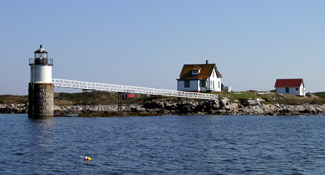

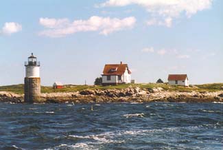
Photo Gallery

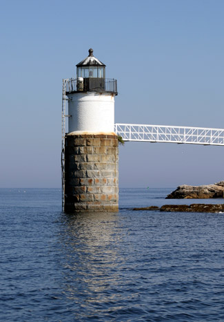

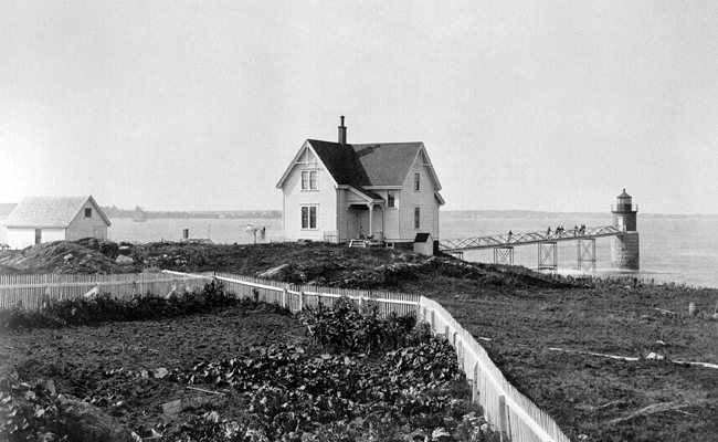

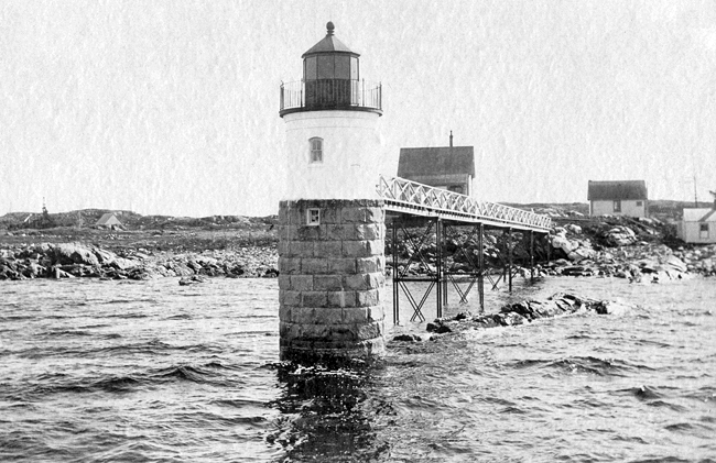

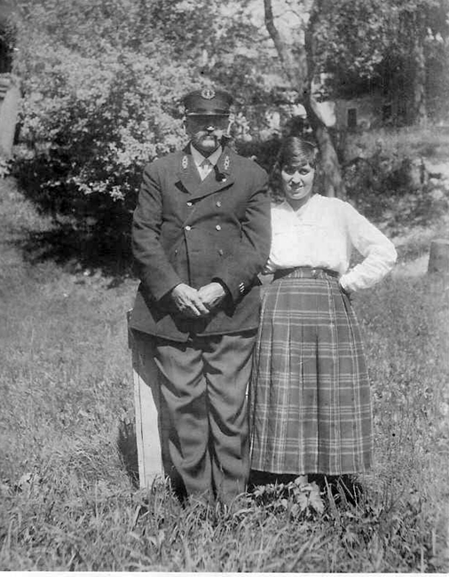


Photo Gallery
Photo Gallery
|
After visiting Ram Island himself, Captain Smith submitted a report to the president of the Board of Navy Commissioners on June 2, 1837 that included the following:
[Boothbay Harbor] is well known as one of the most important harbors upon the whole coast. It is easy of ingress and egress, large, safe in gales from any point of the compass, deep, with good anchorage in any part of it. It is a harbor which all vessels bound east or west, when met by head winds or unfavorable weather, endeavor to make, being a sort of rendezvous for coasters; and more than 300 sail have been seen anchored there at one time. The question, then, is, what works will give to navigation the greatest facilities, and where shall they be placed?Any one much acquainted with nautical affairs, sailing into [Boothbay] harbor from the west, and from it through the eastern passage, will be struck with the advantages a light at the entrance of the eastern passage would give; and there is no point, in my opinion, so well adapted to this end as Ram island. But when the fact is stated, that from that island there are in view four light-houses, and within the compass of twelve or fifteen miles seven lights, viz: Seguin, Pond island, Hendricks head, Burnt island, Pemaquid, Franklin island, and Monhegan, one of two conclusions seems to me inevitable: either that some of these lights are not judiciously located, or that no more are required in that vicinity. I am strongly inclined to the former conclusion. while the present lights are supported, it would not, I think, be judicious to establish another upon Ram island.
Acting on Smiths report, the Board of Navy Commissioners recommended the suspension of expenditures for Ram Island Lighthouse pending a more general examination of the areas lighthouses. Local fishermen were thus forced to take the lighting of Fishermans Island Passage into their own hands. After the first volunteer keeper of this private light left the area, Aldis McKay, a young lobsterman who had benefited from the light, took charge of its maintenance. To improve the beacon, McKay enclosed it in a glassed-in box that he weighted with rocks, so it wouldnt blow over.
|
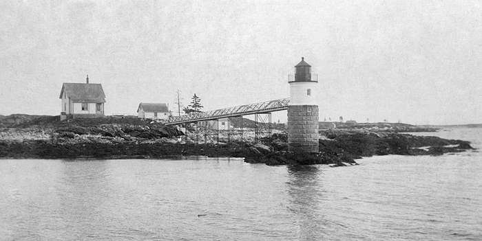
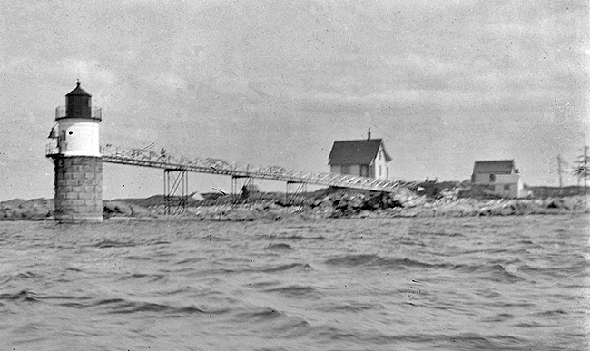
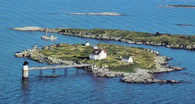
It was not until August 7, 1882, forty-five years after Captain Smiths report, that Congress approved $25,000 for an official light station to guide mariners through Fishermans Island Passage. The government had acquired four acres on Ram Island on July 15, 1837, when it first considered a lighthouse for the passage, so construction could start right away in the spring of 1883. A thirty-five-foot-tall cylindrical tower, which consisted of a substantial granite foundation, a brick central portion, and a cast-iron lantern containing an L. Sautter, fourth-order Fresnel lens, was built atop an offshore ledge and linked to the island with a foot-bridge. The station also included a keepers dwelling, fuel house, boathouse, and landing.
Samuel John Cavanor, who earned $540 annually and had previously served as an assistant keeper at Seguin Island, exhibited Ram Island Light for the first time on November 5, 1883. Before becoming a keeper, Cavanor served aboard the lighthouse tender Iris, where one day his leg was crushed by a buoy that was being hauled aboard. Cavanors leg had to be amputated, but that didnt slow him down. William K. Larkin Jr., a lighthouse service machinist who regularly called at Ram Island, considered Sam to be the most active keeper downeast, in spite of his peg leg.
Ram Island Light was originally fixed white, with two red sectors indicating the clear passages in the vicinity, but on October 1, 1889, the colors were reversed so that white sectors marked the safe approaches and red warned of danger.
The stations walkway was damaged on January 18, 1903, when the schooner Harriet W. Babson, returning from Newfoundland with a load of salt herring, grounded on Ram Island. The light was dark for the next few nights, as Keeper Cavanor couldnt reach the tower to refuel the lamp until the walkway was repaired.
Even the presence of a light station was not enough to curtail the destruction of ships near Ram Island during storms. Keeper Cavanor wrote on December 6, 1884 that after the schooner Mineola ran aground on nearby Squirrel Island, it was a totle rack [sic]; the schooner Garland went ashore in 1885, and nearly every year brought another disaster.
|
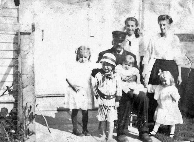
The Cavanors purchased a home in Boothbay Harbor for their retirement, but before they could enjoy it, Keeper Cavanor died of a heart attack near the towns Congregational Church on April 10, 1913. An article in the April 12 Boothbay Register carried the following on the Cavanors: Probably no family in this vicinity were more attached to each other living all those years together on the little island surrounded by every comfort making them all and all to each other.
Captain O. G. Reed, one of Boothbay Harbors old salts, took temporary charge of the light on Ram Island until Almon Mitchell was made keeper on May 10, 1913. Keeper Mitchell had a lengthy career as a keeper, starting as an assistant keeper at Great Duck Island in 1898 and then serving as an assistant at Libby Island and Lubec Channel, before serving as a head keeper at both Petit Manan and Franklin Island. Keeper Mitchells wife Ida died in 1907, after the couple had eleven children. Keeper Mitchell remarried in 1912 and had five more children, the youngest of whom was just two when Keeper Mitchell died of heart failure in 1925 at the age of sixty-eight.
On July 7, 1939, with WWII looming for the United States, the Coast Guard took over the Lighthouse Service. At certain lighthouses, including Ram Island, when the civilian keeper went on leave, a coastguardsman would step in for him. The salary in the Coast Guard in those days was $60 a month, recalled Shirley Morong, wife of a coastguardsman. Our house rent was $8 a month until we moved to a house that had electricity when it was raised to $12 with $2 paying the electric bill.
Not long after Keeper Ralph Norwood transferred to Ram Island in early 1945, he rowed to the mainland with his two sons only to me welcomed by men armed with loaded shotguns. Turns out a skittish neighbor had called the police and FBI to report that German spies were coming ashore.
Ram Island Lighthouse was automated in 1965. A decade later, the Fresnel lens was stolen from the unattended lighthouse, but it was later recovered and is now on display at the Boothbay Regional Historical Society. A modern foghorn replaced the fog bell in 1972, and in 1977 the Coast Guard completed repairs at the station, which totaled $44,000. As part of the work in 1977, the badly deteriorated walkway leading to the tower was removed.
After automation, the station was offered to the town of Boothbay, but the expectation of large maintenance costs deterred the town from accepting the property. With no resident keeper, the station fell victim to vandalism and neglect. When the Coast Guard announced its decision to demolish the keepers house in 1983, Grand Banks Schooner Museum Trust stepped forward and leased the station. The Ram Island Preservation Society was formed and repairs began. The trust was granted ownership of the site in 1998 through the Maine Lights Program, while the Coast Guard retains responsibility for just the active navigational light itself. In 2002, the trust installed a new walkway to the tower, which, besides restoring the original look of the station, simplifies maintenance of the tower by the trust and servicing of the light by the Coast Guard.
Head Keepers: Samuel John Cavanor (1883 1913), O.G. Reed (1913), Almon Mitchell (1913 1925), Alonzo A. Connors (1925 at least 1930), Charles N. Robinson (at least 1935), Benjamin Stockbridge (at least 1939 at least 1942), Merrill Poor (1944), Ralph C. Norwood (1945 1950), Wendell Reece (1953 1958), Harold D. Cummings (at least 1959 1961), Montell R. Jensen (1961 at least 1962), Raymond J. Frenet (at least 1963 1964), Earl Alley (1964 1965), Terry E. Stanley (1965 ).
References:

