Long Point, MA 
Select a photograph to view a photo gallery


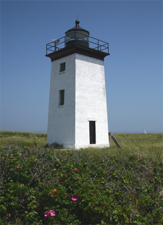
Photo Gallery
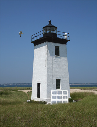
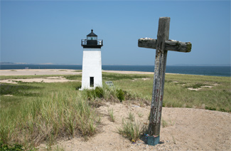


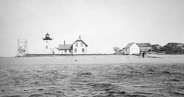
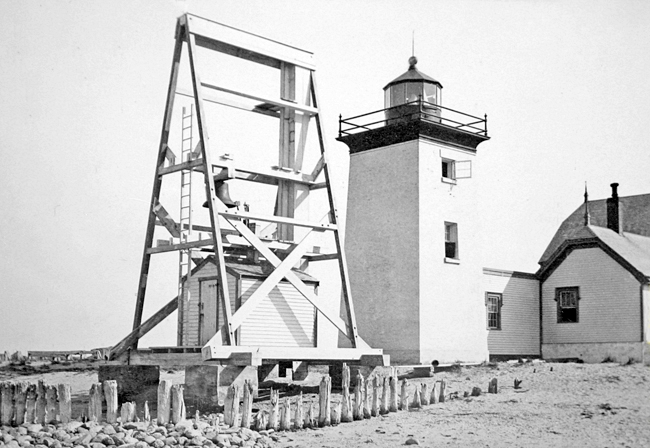
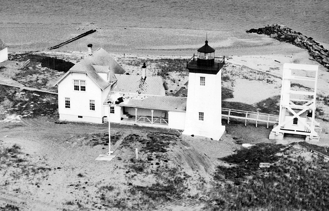
Photo Gallery
Photo Gallery
|
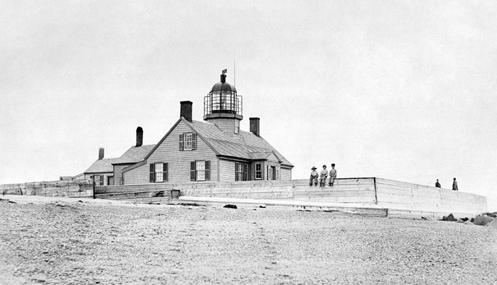
Long Point Lighthouse guided ships into the harbor and warned of a sandbar that extended seaward a quarter mile from the tip of the point. The light was exhibited from a short, octagonal tower centered atop the peaked roof of the wood-frame keepers house that was built on pilings sunk eight feet into the sand. The keepers house had three rooms on its first floor and bed chambers in the attic. As there were similar lighthouses of this style built on the cape during the early nineteenth century, they came to be known as the Cape Cod style. Unfortunately, no lighthouse of this design remains on the cape today.
Long Point Lights first keeper was Charles Derby (1826 1849), who first arrived in Provincetown in 1798, as the four-year-old ward of the captain of the whaling ship Polly. Starting in 1830, a school, the first at Long Point, operated at the lighthouse. It began with three students and expanded until it was replaced by another schoolhouse in the village in 1846.
This is an exceedingly useful light, but far larger than is necessary, noted Lieutenant Edward W. Carpender of the U.S. Navy in 1838. He recommended that four of the ten lamps, which were backed by fifteen-inch reflectors, be suppressed and added, This house was in danger from the sea until Government built a ledge, or breakwater, outside of it; since which, the keeper and his family have experienced less anxiety for their safety. The breakwater consisted of an enclosure of spruce logs around the dwelling that was filled in with sand and protected with 1,800 tons of large rock were placed around its perimeter.
Keeper Derby wrote in 1842 for I.W.P. Lewis lighthouse survey that he had no well and relied on rainwater collected in a cistern, and while he was allowed a boat, there was no landing or boathouse. That year Derbys boat was damaged in a storm and he spent $25 of his $350 annual salary to repair it.
In 1853, the year Keeper Derby left the lighthouse, it was noted that the east side of the beach south of the lighthouse had worn away, but since the deterioration appeared to be slow, no corrective measures were recommended.
A fifth-order Fresnel lens replaced the lamps and reflectors in 1856, and 1869 saw the illuminating apparatus and fixtures overhauled, cistern pump renewed and timepiece cleaned. As the extremity of the point where the lighthouse stood continued to wash away, it was conjectured in 1869 that it may be necessary at no distant day to move the light further inland. Little or no action seems to have taken place, because by 1873 the foundation of the keepers dwelling was exposed and the entire structure, which was by then resting on decayed piles, was in danger of being carried off by a heavy storm. A new dwelling and tower were deemed indispensable, and in 1874, $13,000 was approved for this work along with the addition of a fog signal.
|
From 1870 to 1882, John Thomas Dunham was employed as keeper of Long Point Lighthouse. Dunham was a Provincetown native fitted with a wooden leg as a result of a whaling accident.
During the winter of 1874-75, a giant, twenty-two-mile-long ice field engulfed Provincetown, stretching from Wood End to Manomet. A local historian described it as follows: A fleet of fishing vessels was caught in the floe and stood there; their hulls, rigging, and tapering spars encrusted with ice, like fairy vessels of glass. It was one immense crystalline desert with signals of distress fluttering from the immobile craft, a scene of perilous beauty and wicked enchantment.
In 1880, although the settlement at Long Point had shrunk considerably, Keeper Dunham was still greatly disturbed by the flies and stench coming from the nearby fish-oil works.
Erosion caused by storms in late 1898 and early 1899 looked poised to transform Long Point into an island. Of these storms, the Portland Gale was the worst. Keeper Samuel Soper Smith, who had been at the station since 1888, was sick when the November 26-27, 1898, Portland Gale hit. Despite his illness, Smith knew he must wind the fog-bell striking mechanism every few hours. Braving the storm, he was struck in the chest by a wave that flung him backward, but he continued climbing into the machinery building to wind the bell. Smith described the storm to the Boston Daily Globe in an 1899 article:
On the morning of Nov. 27 the whole end of the point was flooded. The buildings shook and cracked ominously under the push of the hurricane, but the greatest danger threatening was that of the waves. The air was full of water salt water, blown like fog from the crests of the seasThe house somehow survived, but the boathouse was damaged, wooden walkways swept away, the breakwater partially destroyed, the cistern filled with salt water, and the woodshed demolished.The tide kept rising until at last it was four feet deep all around the house. My wife and a lady friend expressed their fear that our house would be swept away. I pointed to our outside water tank, an immense cask, nearly filled with fresh water, weighing a ton at least, which stood under the eaves and told them that they need not fear as long as it remained there. Just as I spoke it lifted, and next minute went around the corner of the house, upright, and it was carried around the sand battery, out of sight to the westward.
|
Other members of lighthouse keepers families faced regular difficulties, which they took in stride. Nine-year-old Mary was one of Keeper A.G. Ted Haskins three daughters, who lived with him and his wife at Long Point Lighthouse in the early 1930s. Every day she boarded a thirty-six-foot powerboat to travel over a mile to school and back. A 1932 Boston Globe article noted that in spite of foul weather Mary had not missed a single day of school in over a year.
One fog-choked day in May 1933, the fog bells striking mechanism gave out. Knowing the importance of the signal, Keeper Theodore Chase manually pulled the bell with his right hand the prescribed three times every minute for nine straight hours. He slept a few hours then returned to the task with his left hand. Although the fog cleared, Chase later proclaimed hed been ready to tie the rope to his legs to keep ringing, if necessary. He said he felt like a baseball pitcher who has twirled a couple of doubleheaders without rest.
Long Point Lighthouse was automated in 1952, and the fourth-order Fresnel lens, which had replaced the earlier lens in 1927, was replaced by a modern optic. In 1981 solar panels were installed.
Long Point Lighthouse is still active, with a fixed-green light and an automated fog signal. A brick oil house, dating from 1904 remains standing as well, but the keepers dwelling and fog-station building were removed long ago. There is a movement afoot to rebuild the keepers house and use it as a tourist attraction to connect people with their heritage. Overnight stays in the dwelling might even be offered.
Although the Coast Guard still owns the lighthouse, the American Lighthouse Foundation was granted a license in 1998 to maintain the structure. Since this agreement was signed, the Cape Cod Chapter of the American Lighthouse Foundation has repeatedly teamed up with New England Lighthouse Lovers to paint the exterior of the oil house and the exterior and interior of the lighthouse.
Head Keepers: Charles Derby (1826 1847), Elisha Freeman, Jr. (1847 1849), Charles Derby (1849 1853), Jesse Freeman (1853 1855), Daniel Smith (1855 1856), Hiram J. Snow (1856 1862), Ebenezer W. Holway (1862 1867), Eliphlet H. Whelden (1867 1870), John T. Dunham (1870 1882), Herman F. Smith (1882 1888), Samuel S. Smith, Jr. (1888 1904), Charles A. Havender (1904 1905), Roscoe G. Lopaus (1905 1909), Samuel S. Smith (1909 1919), Edward H. Hopkins (1919 1922), Gerald M. Reed (1922 1926), Allison G. Haskins (1927 1932), Theodore L. Chase (1932 1942), Charles Cain (at least 1946), Frank H. Peloquin (1948), Joseph R. Poindexter (1949), William H. Swanson (at least 1950).
References


