Craighill Channel Upper Rear, MD 
Select a photograph to view a photo gallery

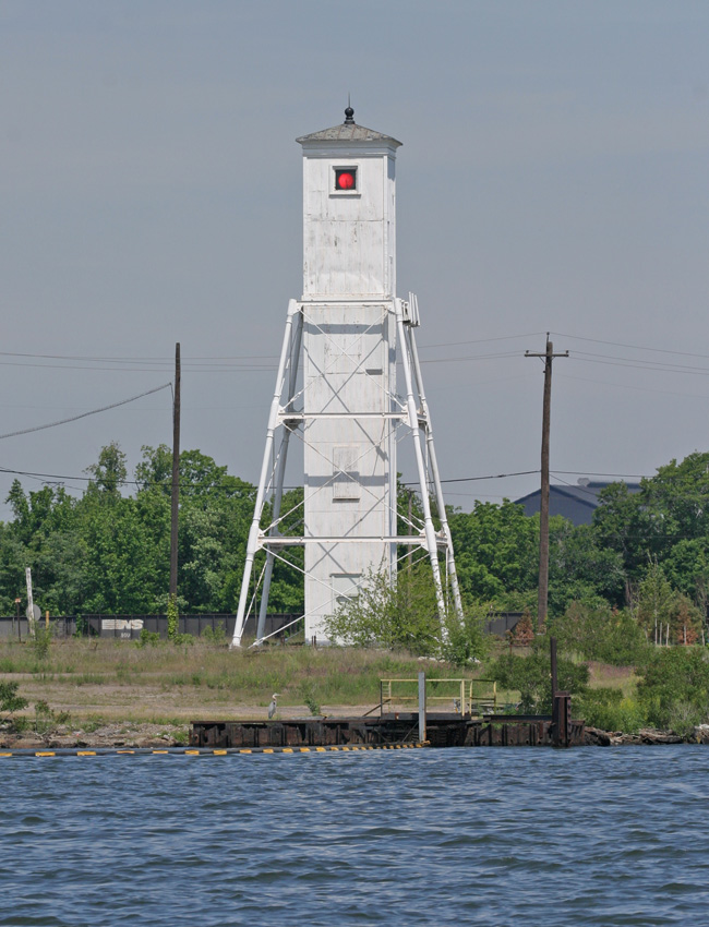
Photo Gallery
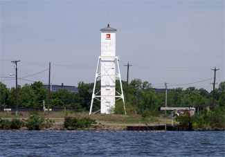
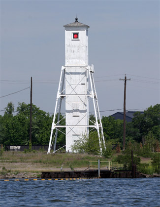


Photo Gallery
Photo Gallery
|
Unlike the construction of the Lower Craighill Channel Range Lights, the erection of the lights for the Cutoff Channel was relatively problem-free and did not require any additional funding over the original $25,000 appropriation. The front range light consists of a twenty-five-foot-tall octagonal brick tower built on the thirty-foot-square, stone foundation pier of the former rear light of the North Point Range, originally constructed in 1822. While some thought was actually given to refurbishing the structure at that location that was abandoned with the establishment of the Lower Craighill Channel Range Lights, the Lighthouse Board reported that careful examination showed it to be entirely unsuitable for the purpose, and it was deemed more practical to tear it down and build a more secure structure. The front light is located roughly 1.3 miles southeast of the rear light, near the mouth of the Patapsco River.
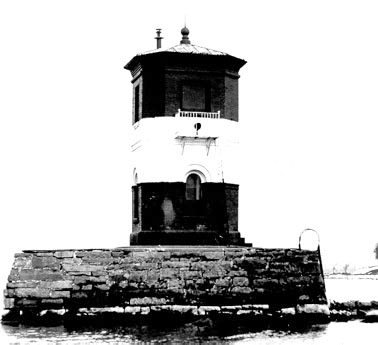
As described by the Lighthouse Board, The rear beacon consists of an inner wooden shaft, covered with corrugated iron and supported by an iron skeleton frame, forming a frustum of a square pyramid, resting on stone and brick foundation piers. The central shaft encloses a stairway that facilitated access to a gallery and the light at the top of the tower. The rear light is positioned sixty-five feet above the water and forty feet above the front range light.
|
In its annual report of 1888, the Lighthouse Board noted that the gates to the property at the front light had to be relocated as the owner of the adjoining property had declined to allow the keeper to pass over his property any longer. Access to the rear tower is even more complicated today as it is located within the grounds of the Sparrows Point Bethlehem Steel Plant.
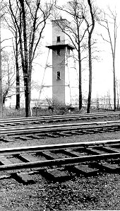
In 1890, extensive work was done on the dwelling for the front light. The interior was painted, roof repairs were made, and a new picket fence and brick walkways were added, and seventeen window screens and two screen doors were hung. Unfortunately, just three years later, the wooden bridge that connected the mainland to the front light was destroyed in a storm. Rather than rebuild the bridge, the locomotive headlight was moved outside the tower, and the small structure was remodeled to serve as quarters for a keeper. The front light does somewhat resemble a guard shack, and the twelve-foot square tower with truncated corners, now had a resident guardian. A boat landing and davits for storing the keepers boat were added to the front light at this time.
Oil lights set in locomotive headlight reflectors were used in the range to produce a pair of white lights until 1914, when acetylene lights were installed in the towers and the characteristic was changed to flashing white. The front range light was electrified in November 1929 with current being obtained from the lighting system at Fort Howard through a 650-foot-long submarine cable, and at this time the signature of the range lights was changed to fixed red.
With the installation of the acetylene lights in 1914, only one keeper was needed for the range lights, and the services of Frederick Burmeister and his son were discontinued. Frederick Burmeister was appointed custodian of the front light, receiving an annual salary of just one dollar and being allowed to continue living in the dwelling at Fort Howard. Keeper Burmeister turned seventy in 1914 and had been offered the position of keeper at Fort Carroll, but he felt his health would not permit him to continue to render efficient service. The rear light retained its keeper until 1922, when Allie Davis was transferred to the Annapolis Depot.
The Cutoff Channel Range Lights are a prime example of governmental efforts to produce more efficient aids to navigation. The front range light, with its striking red and white bands and molded brick arches is quite pleasing architecturally. Although the rear range light has lost its gallery that encircled the tower atop the four iron supports and its windows have been boarded up, the tower is a one-of-a-kind.
Head Keepers: John Peterson (1886 1892), Charles A. Green (1892 1919), Albert (Allie) L. Davis (1919 1922).
References