The City of New Orleans lies between the winding Mississippi River to the south and the shores of Lake Pontchartrain to the north. In the 1830s, a team of Irish and German immigrants constructed a canal from Lake Pontchartrain to the citys interior. The canal was filled in years ago, but indications of its existence can still be seen along its route that followed present-day West End Boulevard to the Pontchartrain Expressway (I-10) and terminated in a turning basin near the site of the Superdome. This canal wasnt the first to penetrate the city, just the most recent. Hence, it was given the descriptive appellation New Canal.
Before the canal was completed, Congress had authorized funds for the establishment of a light at the entrance to New Canal. The lighthouse was an octagonal, wooden tower resting on pilings driven into the lake bottom and was built by Francis D. Gott under a contract for $4,500 that was signed on July 31, 1838. Nine oil lamps set in fourteen-inch reflectors were used in the towers lantern room to produce a fixed white light at a focal plane of thirty feet. This first New Canal Lighthouse was completed by February 1839, but after just four years, the towers lower timbers had rotted, causing it to lean. In 1853, Danville Leadbetter, the lighthouse inspector for the Gulf of Mexico, wrote that the three lighthouses on Lake Pontchartrain, including New Canal Lighthouse, were wholly worthless and were being repaired only in the hope of making them serve till new ones can be built. The towers underpinnings were strengthened that year and its copper deck repaired in the hope of making the tower last a few more years.
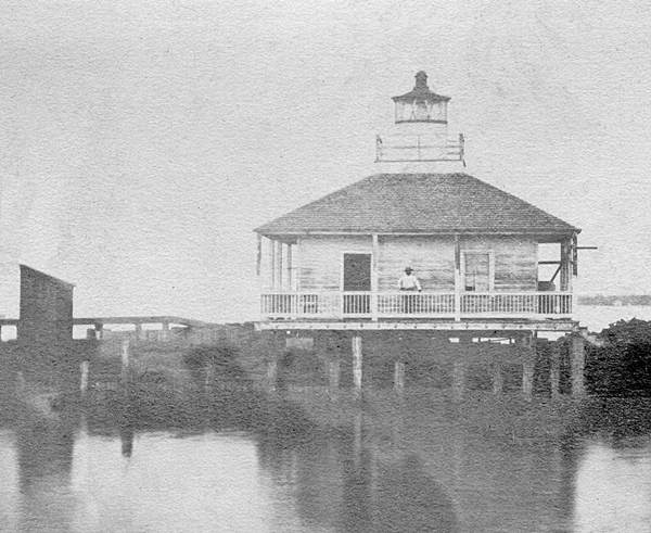
On August 3, 1854, Congress appropriated $6,000 for a new light-house at New Canal, in place of the present structure, which will not admit of being repaired. The second New Canal Lighthouse, a square, one-story structure supported by iron pilings, was completed in 1855. The towers four-sided roof sloped upwards to the lantern room, which held a fifth-order Fresnel lens.
During the Civil War, the Confederates kept the light active until New Orleans fell to Union forces in April 1862. After damage to the lighthouse was repaired, the light was relit the following year with its pre-war keeper, William A. Waldo, being reappointed.
In 1869, a substantial breakwater was built on the east side of the lighthouse, and a slate roof replaced the old wooden shingles to protect the building from the sparks of passing steamers and its own stovepipe.
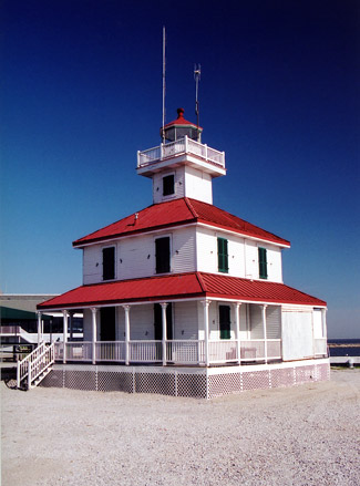
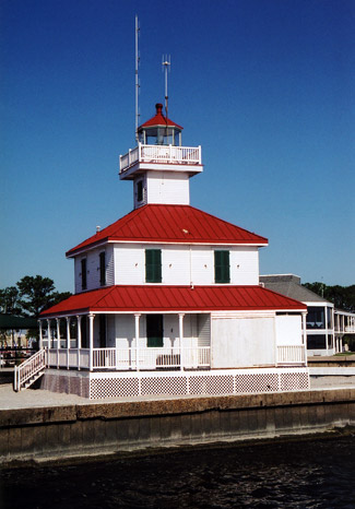
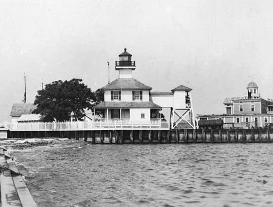
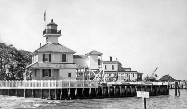
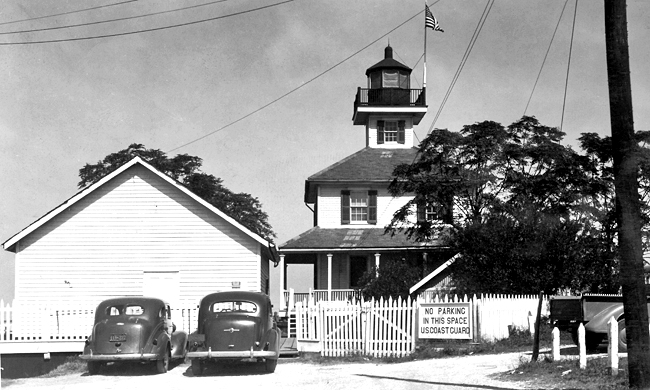
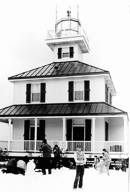
Around 1880, a substantial yacht club was built northwest of the tower, partially obscuring the light. The Lighthouse Board talked of discontinuing the light, but decided rather to build a new taller lighthouse. The light was discontinued on February 25, 1890, and a temporary lens lantern was displayed from a pole. The old lighthouse was sold at public auction on February 26 and removed from the site a few days later. The new white, two-story lighthouse was built on an iron-pile foundation and was surmounted by a black fifth-order lantern room. The focal plane of the light, activated on June 2, 1890, was now forty-nine feet, sixteen feet higher than before.
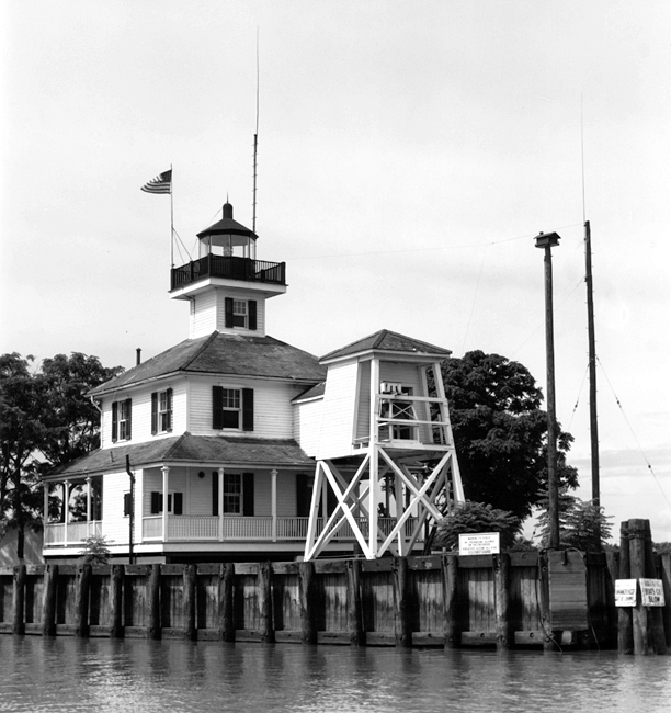
On July 7, 1898, a 1,200-pound bell, suspended in a tower and struck by machinery, commenced operation at the station. Fog was common on Lake Pontchartrain during certain periods of the year and greatly slowed navigation. As the lakes shoreline was quite regular, it was believed that a fog bell would allow vessels to keep on their way in foggy conditions. A covered way connecting the bell tower to the lighthouse was built in 1901, and an oil house was added to the station in 1909.
New Canal Lighthouse just might hold the record for having the most female keepers. At least five women served at the station, most of whom took over when their husbands died while serving as keeper. Elizabeth Beattie became keeper in 1847 after her husband Thomas, who was the first keeper of New Canal Lighthouse, passed away. Keeper Caroline Riddle received commendations for securing the lens and hanging a lantern in the tower during a powerful hurricane in September 1915. As the storm struck, the barometric pressure fell to a U.S. record low of 28.11 inches, while Lake Pontchartrain rose above its levees, flooding parts of New Orleans.
Keeper Margaret Norvell is remembered for her valiant rescues. On one occasion, she used the stations rowboat to save a Navy pilot, who had crashed his biplane into the lake. In 1925, she helped evacuate passengers from the ferryboat Southland that caught fire and sank near the lighthouse. Margaret Norvell retired on April 30, 1932 after nearly forty-one years of service as a keeper. She was appointed assistant keeper of Head of Passes Lighthouse upon the death of her husband in 1891, and later served at Port Pontchartrain Lighthouse before being transferred to New Canal Lighthouse.
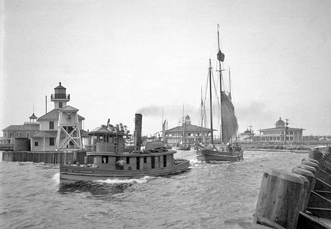
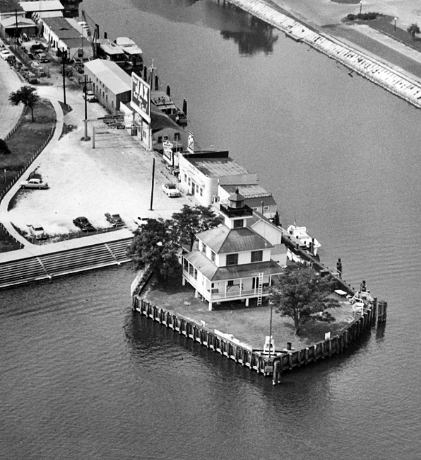
New Canal Lighthouse originally stood approximately 1,000 feet offshore, but landfill projects in the early 1900s slowly brought the shore to the lighthouse, creating what is now Lakefront Park. The lighthouse served as a Coast Guard Station with a search and rescue detachment from the early 1960s until a new facility was completed in Bucktown in 2001.
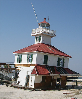
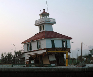
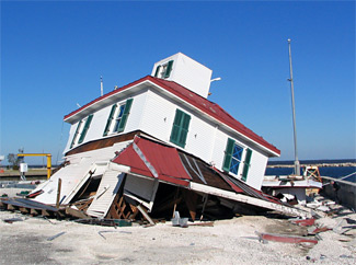
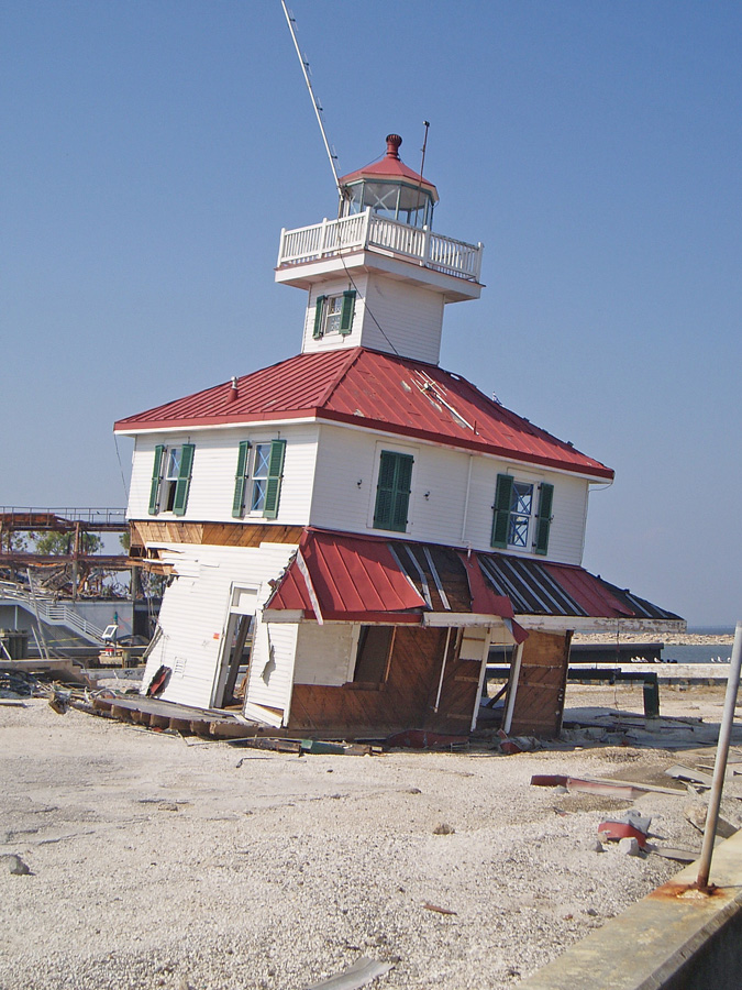
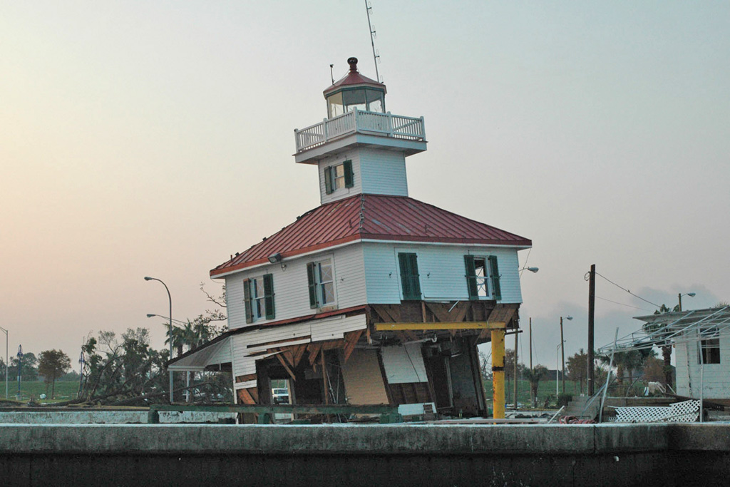
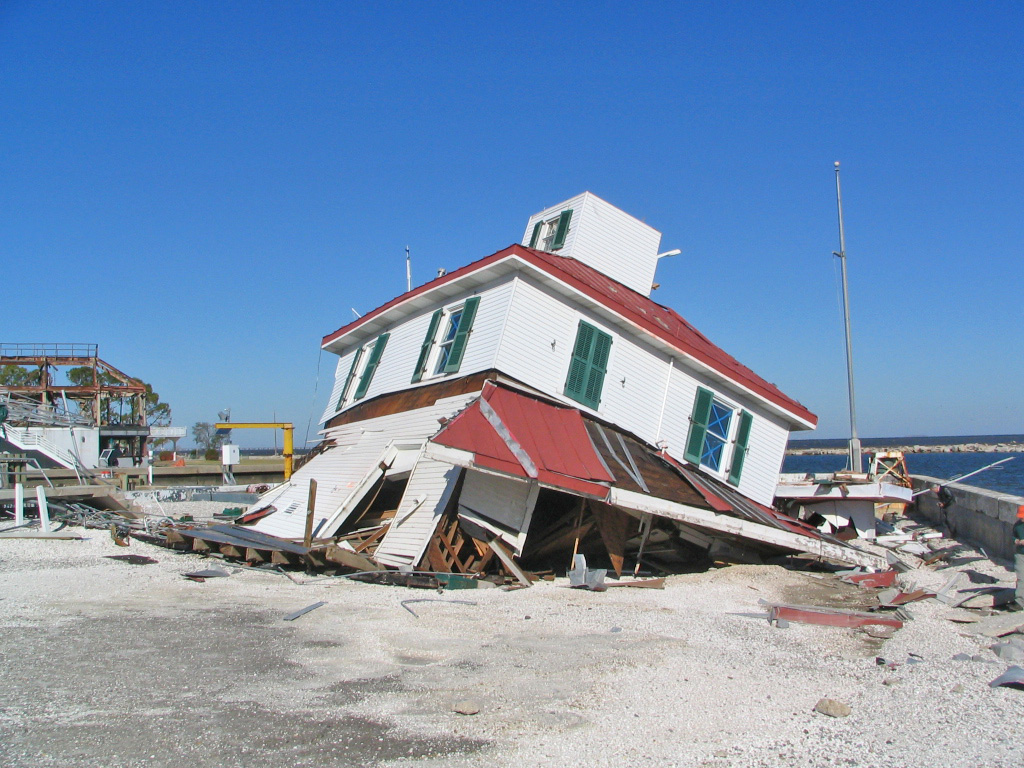
On August 29, 2005, Hurricane Katrina ravaged the City of New Orleans. The storm, which is the costliest natural disaster in the history of the country, destroyed several lighthouses and inflicted significant damage to others. New Canal Lighthouse, sitting as it does on the shores of Lake Pontchartrain, was inundated by the storm surge accompanying the hurricane. This
photograph submitted by Dave Lockhart and the one at right provided by Anne Rheams show the extent of the damage to the lighthouse. Though heavily damaged, the lighthouse remained upright and mostly intact until a cold front the following November caused the unstable lighthouse to
keel over and lose its lantern room.
The Lake Pontchartrain Basin Foundation (known now as Pontchartrain Conservancy) had been seeking ownership of New Canal Lighthouse since the Coast Guard left the lighthouse in 2001. Just before Katrina, LPBF was participating in the National Historic Lighthouse Preservation Program with a goal to turn the lighthouse into an education center for the public. Undaunted by the damage inflicted by Katrina, LPBF signed a lease with the Coast Guard in September 2006 to restore the lighthouse. Site cleanup and stabilization, which together cost around $75,000, had to be completed before any restoration could begin.
During the fall of 2007, the remains of New Canal Lighthouse were dismantled, and any historic materials that were salvageable were retained. In July 2011, a $439,000 construction contract was signed by Certified Construction Professionals and Chris Holmes, Board Chairman for the Lake Pontchartrain Basin Foundation. Prom Dagoglou of Certified Construction Professionals grew up where he could see the lighthouse and says the rebuilding of the lighthouse is something were going to be putting our heart and souls in.
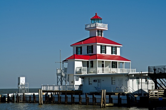
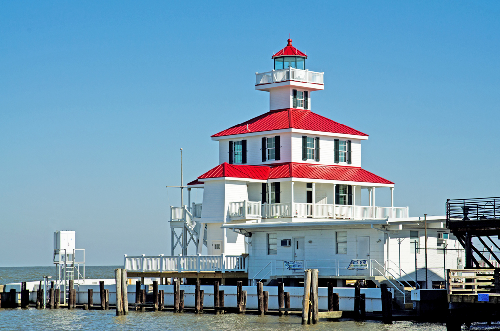
A groundbreaking ceremony was held at the lighthouse on February 27, 2012, and later that day a truck unloaded pilings to raise the lighthouse nineteen feet above the ground to prevent damage from future storm surges. On August 21, 2012, the lantern room was hoisted atop the rebuilt New Canal Lighthouse. A relighting ceremony scheduled for August 29 had to be postponed as Hurricane Isaac struck New Orleans that day on the seventh anniversary of Hurricane Katrina. The ceremony, which featured a fundraising run, was eventually held on September 26, 2012. Tom Benson, owner of the Saints and FOX 8, had the honor of flipping the switch. This has meant so much to our city, said Benson. Its like our city. Its been here forever. Thats why we wanted to light it up again.
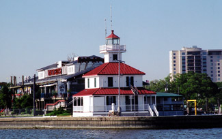
The interior of the lighthouse features interactive displays depicting the history of the lighthouse and the New Basin Canal, the ecology of Lake Pontchartrain, and the impact of Hurricane Katrina on the surrounding area. The grand opening of the lighthouse was held on April 19, 2013.
Mark Hatcher provided this photograph of the restored lighthouse.
Keepers:
- Head: Thomas Beattie (1839 1847), Elizabeth Beattie (1847 1849), L. S. Joly (1849), Humphrey M. ODriscoll (1849 1850), Jane ODriscoll (1850 1853), Caleb Leonard (1853), Robert H. Jones (1853 1854), Isaac F. Williams (1854 1855), Israel Brull (1855 1857), Augustus Welch (1857 1859), William A. Waldo (1859 1866), Augustus F. Campbell (1866 1869), Mary F. Campbell (1869 1893), Caroline Riddle (1893 1924), Margaret R. Norvell (1924 1932), James T. Williams (1932 1938), Englisbee K. Peyton (1938 1939), Grady Farrington (1939 1941), Englisbee K. Peyton (1946 1948), Englisbee K. Peyton (1948 1949), Willard J. Trochesset (at least 1959 1960), Mackie W. Whatley (1960 1961), David H. Griffice (1961 1962), Elvin W. Lane (1962 1964), Thomas E. Wood (1964 1965), Jesse C. Smith (1965), Pierre J. Descant (1966), James W. Elliott (1966 1967), Robert J. Schoelzel (1967 1968), James W. Keith (1968 1970), J.F. Winnington (1970 ).
- Assistant: Robert H. Jones (1853 1857).
- USCG: Pauld D. Lennox (at least 1959 1960), James C. Lopitz (at least 1959 1961), Fred J. Hecht (at least 1959 1960), Ronald J. Giroir (at least 1959 1960), Urben D. Gibbs (at least 1959 1960), Earl R. Cooper (1960), John Moreno (1960), Cyril T. Wilkinson (1960 1961), Garvis G. Fincher (1960 1961), James E. Dickerson (1960 1961), Maurice I. Wales (1960 1961), Robert E. Holbert (1960 1962), Charles R. Miley (1960 1961), Harold F. Pauls (1960 1961), Everett L. Kuehn (1960), Donald J. Webb (1960 1961), Giles D. Loftin (1960 1962), Simm A. Powell (1960 1961), David L. Estes (1960 1962), Cecil E. Moncrief (1960 1961), Eric B. Smith (1960 1961), Emanuel W. Beritiech (1961), Henry E. Gibbons (1961), Rayford L. Davenport (1961 1962), Sebream R. Griffin (1961 1963), Carl B. Alexander (1961 1963), Harvey R. Patteson (1961 1963), Arley E. Burton (1961), Alexander W. Young (1961), Tommy E. Jarrell (1961 1963), Terrell E. Landrum (1961 1962), Leland W. Harrist (1961 1962), Bobby Sanders (1962), Ervin M. Farrow (1962 1963), Allen M. Browning (1962 1963), Terry D. Cates (1962 1963), Readius J. Silcox (1962 1963), Frank S. Montelaro (1962 1963), Bobby L. Grimsley (1963 1965), Oscar J. McCormik (1963), D. J. Guillot (1963), Carl W. Feil (1963 1964), James A. Stubbs (1963 1966), Joseph P. Jurczak (1963 1967), Steven B. Barton (1963 1964), Larry H. Wiggins (1963 1967), Richard C. Lawson (1963 1964), Charles J. Bredehoft (1964), Robert R. Smith (1964 1966), Glenn H. Warner (1964), Charles E. Herndon (1964 1966), Larry A. Robinson (1964 1966), Theron G. Boyd (1965 1966), Robert D. Pleasant (1965 1966), Jon B. Wilmot (1965 1966), Alvin J. Pekinto (1965 1966), Larry J. Bass (1965 1967), Jesse C. Smith (1966 1967), Mitchell K. Whichard (1966 1968), Jack D. Asbury (1966), Marvin G. Shipp (1966 1968), Gary Willard (1966 1967), LeRoy Stadler (1966 1968), Steven B. Barton (1966 1967), Curtis Lemoine (1966 1970), Robert L. Nichols (1967 1968), C.F. McCrory (1967 1968), George L. Silva (1967 1968), R. Bonilla (1967 1968), Harry Langley (1967), Harvey R. Patteson (1967 1968), Jerry G. Kruithof (1967 at least 1971), George E. Lear (1967 1969), John L. Chase (1967 1968), Eric C. Wright (1968 1970) Jack F. Coleman (1968 1970), Charles E. Mosley (1968 1969), W.W. Aaron (1968), Byron Terrell (1968 1969), John Myles (1968 1969), Robert W. Duncan (1968 1969), Carlton Patterson (1968 1969), Malcolm J. Currey (1969 1970), L.D. Bond (1969 1970), Tex G. Simmons (1969), Clifford D. Bland (1969 1970), W.H. Wetherington (1969 at least 1971), Charles D. Chapman (1969 at least 1971), Timothy Bailey (1969 1971), Robert M. Benke (1969 1970), K.W. Daniels (1970), W.C. Keenan (1970 at least 1971), John W. Frase (1970 at least 1971), Robert Casale (1970), Daniel A. Monroe (1970), Robert C. Strader (1970 at least 1971), Francis J. Babin (1970 at least 1971), E. Harris (1970), R.P. Schuler (1970).
References
- Annual Report of the Lighthouse Board, various years.
- Lighthouses, Lightships, and the Gulf of Mexico, David Cipra, 1997.
- Inventory of Historic Light Stations, National Park Service.
- Action Report: Work about to start on historic lakefront lighthouse, Bill Capo, WWLTV, July 26, 2011.
- Residents celebrate lighting of New Canal Lighthouse, Jessica Holly, fox8live.com, September 26, 2012


