Morris Island, SC 
Select a photograph to view a photo gallery
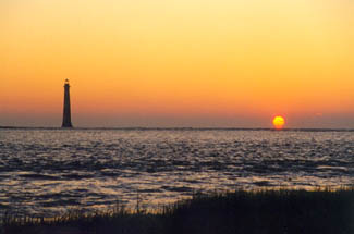

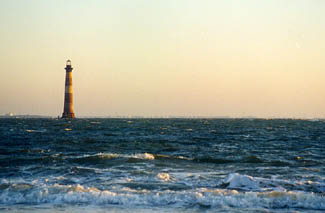
Photo Gallery

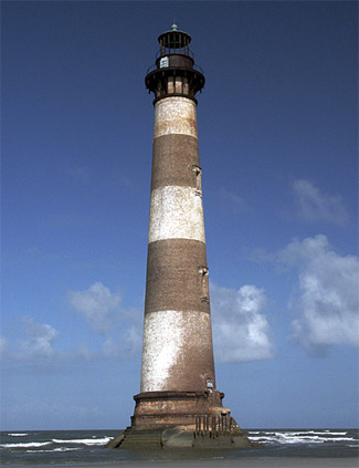

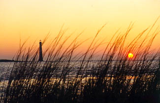
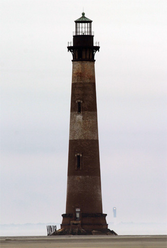
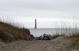
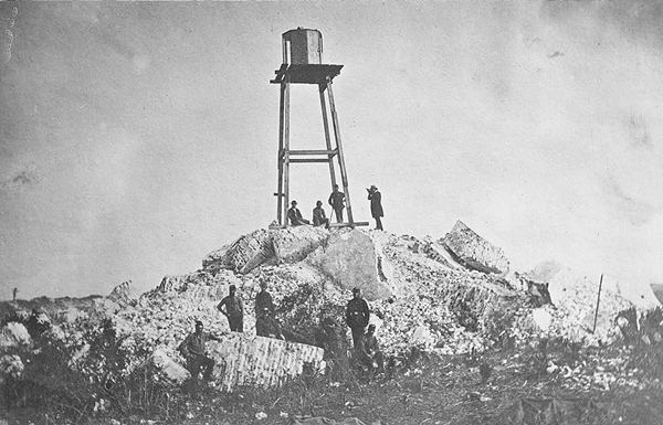
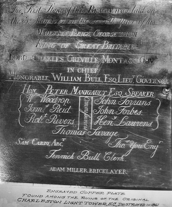


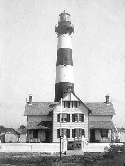

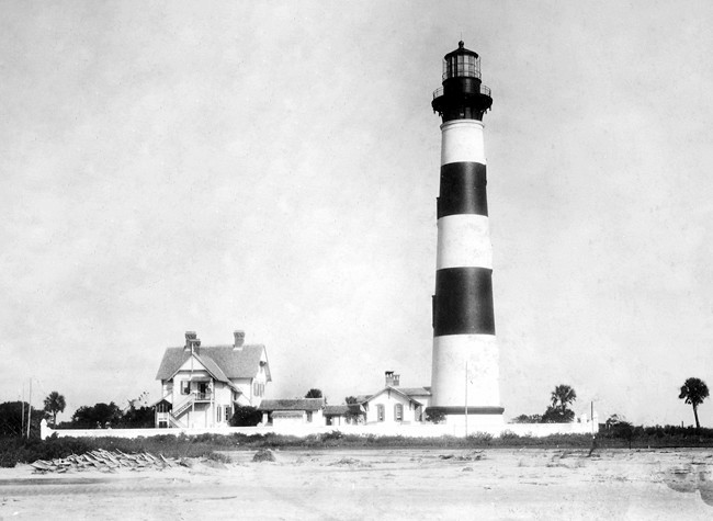


Photo Gallery
Photo Gallery
The first settlement in the area of present day Charleston was made in 1670. At that time, two channels led to the harbor. One ran east along Sullivans Island and the second ran south along what is now known as Morris Island. Before the 1800s, Morris Island was actually three separate islands. The northernmost was called Cummings Island, the central was called Morrisons Island, and the southernmost was known as Middle Bay Island. When the inlets that separated the islands silted in, the resulting large island became known as Morris Island.
|
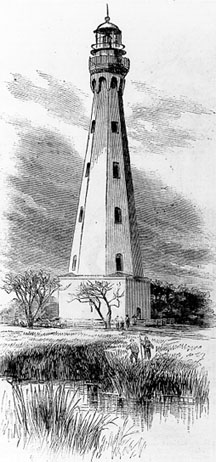
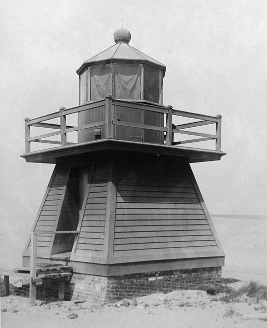
The tower rose forty-three feet and served well, until it was heavily damaged during the Revolutionary War. After the war, one of the first acts of the new Congress in August 1789 was to establish the Lighthouse Service, which took control of all existing navigational aids. The following year, the South Carolina Legislature transferred Charleston Lighthouse, which had been recently repaired, to the federal government along with 565 acres on Middle Bay Island. Using a $5,000 appropriation granted on May 7, 1800, repairs were made to Charleston Lighthouse that were needed after the tower caught fire in July 1799. The following November, the superintendent of lighthouses announced that the lighthouse had been rebuilt and that the stone and brick structure had been equipped with an iron lantern covered with copper. In 1816, the lantern stood eighty-five feet above the sea, and the light was changed on the first of November of that year from fixed to revolving to distinguish it from Georgetown Lighthouse.
In 1855, Captain Daniel P. Woodbury recommended that $11,000 be allocated for installing a first-order Fresnel lens atop Morris Island Lighthouse along with $4,000 for a dwelling to replace the current one that was very old, and not fit to live in. Congress appropriated $15,000 on August 18, 1856 for the lens and dwelling, and a fixed, second-order Fresnel lens was activated atop the lighthouse on January 1, 1858, taking the place of the old revolving apparatus. At that time, the tower was listed as 110 feet tall, and the light had a focal plane of 133 feet above the mean level of the sea. The light from a fourth-order fixed lens was exhibited from a scaffold outside the southeast face of the lighthouse starting on November 20, 1857 and continuing in use while the second-order lens was being assembled inside the lantern room. This temporary light had a focal plane of ninety feet.
When it became the first state to secede from the Union in December 1860, South Carolina took control of all the lights on its coastline and towed the Rattlesnake Shoal Lightship into Charleston Harbor. The Fresnel lens was removed from Morris Island Lighthouse, and the tower was converted into an observation post. Just a few months later, in April 1861, shots were fired at Fort Sumter, located just north of the lighthouse at the entrance to the harbor, and the Civil War was underway. The Confederates were able to hold onto Charleston for most of the war, but during the course of the conflict, much of the city was burned or blown up, and Morris Island Lighthouse was destroyed. According to a newspaper account, the lighthouse was blown up by order of the rebel military authorities on December 25, 1861. This engraved copper plate found among the ruins of the lighthouse notes that the architect and bricklayer for the original tower were, respectively, Sam Cardy and Adam Miller.
|
In 1872, the Lighthouse Board noted the need for a major light on Morris Island:
Previous to the war, there was a sea-coast tower and light at this station, and the same reasons that existed for establishing it then, exist still. It will be observed, by reference to the chart, that along the coast, from Cape Romain to the River Saint John continuous shoals extend out from the main-land to a considerable distance, in many places reaching out as far as six and seven miles. Timely warning of their proximity is necessary for the safety of the lives and cargoes of the large number of vessels that pass them. This can only be given by the establishment of sea-coast lights, or by placing light-ships outside of them. The latter is by far the most expensive plan, besides being open to serious objections. The present light, owing to want of sufficient range, leaves a dark space on the South Carolina coast, between it and Hunting Island, which should be lighted. This can and should be done by making a new rear tower on Morris Island, 150 feet above the sea, and establishing on it a first-order sea-coast light.
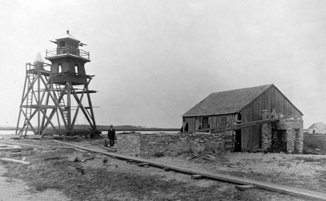
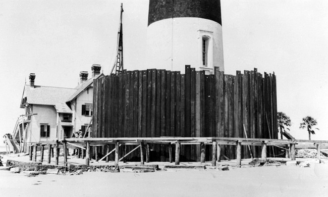
After Congress provided funds, a site for the new Charleston Main Light on Morris Island was selected at a location 1,700 feet northeast of the rear beacon on the island. A storehouse and quarters for workers were built on the island along with a wharf for landing material and a railway for transporting material from the landing to the construction site.
To provide a proper foundation for the new Morris Island Lighthouse, over two hundred wooden piles, spaced three feet apart, were driven into the sand and cut off below water level. The outer two rows of piles were driven to a depth of fifty feet, while the interior ones were driven to a depth of between twenty-five or thirty-five feet. Atop the piles, a grillage made up of two layers of twelve-inch-square timbers laid at right angles was placed. The space between the grillage timbers was filled with cement to form a foundation that had a diameter of thirty-six feet. This sizable foundation was necessary to support the brick tower, which would rise over 150 feet into the air and weigh close to 4,000 tons.
By the end of June 1874, seventy-nine of the piles had been driven, but work had to be suspended due to the unhealthiness of the climate during the summer months. An additional $60,000 was provided by Congress on June 23, 1874, which allowed work to resume in November. By the summer of 1875, the foundation was complete, and all of the metalwork had been delivered to the site save for a small portion that was lost by the sinking of a lighter and was being duplicated by the contractor.
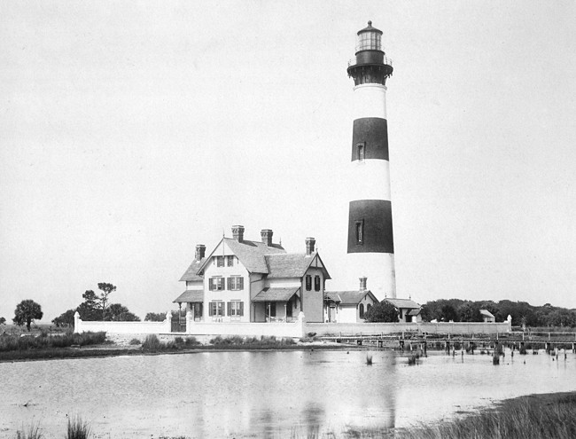
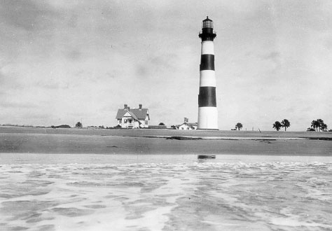
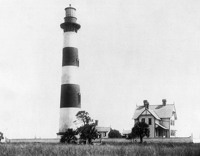
On March 3, 1875, Congress provided $30,000 for completing the lighthouse, bringing the total funding for the project to $150,000. Work on the brick tower began in October 1875, and by the following summer it was complete, and the first-order Fresnel lens had been installed. A three-story dwelling was built sixty feet south of the tower for the keepers, and the light from the towers lens was activated on October 1, 1876 with George W. Williams serving as head keeper and Richard M. Jones, George W. Veronee, and John Barrett as his assistants. The tower was built using the same plans as Bodie Island Lighthouse and was painted with the same daymark: alternating black and white horizontal bands, three of each color, starting with black at the lantern room and watchroom.
|
Before erosion had washed away the towers buffer zone, other forces of nature tested the integrity of the lighthouse. First, in 1885, a powerful hurricane, packing winds in excess of 125 miles per hour, struck the Charleston area. The storm claimed twenty-one lives in Charleston and destroyed the rear beacon on Morris Island and overturned the boathouse. Then just a year later, an earthquake struck. The quake destroyed several structures in Charleston, including two churches, and killed around 100 people. Morris Island Lighthouse was cracked in two places, and the giant lens was displaced and a piece was broken out of it.
Keeper John Wieking noted that it was 9:53 p.m. on August 31 when he left the house to climb the tower for his watch. While he had the doorknob at the house in his hand, he heard a rumbling sound and felt the earth first tremble and then start tearing and jerking. The wire net around the lantern room and other metalwork made a great noise as the tower shook and trembled terribly. The stations horses and cows were frightened greatly and ran about. After the earthquake, several cracks in the ground, ranging from two to four inches wide and ten to one hundred feet in length, were observed around the lighthouse. About twenty fissures emitted sand and water for some time, before closing up.
Using a boatswains chair lowered from the top of the tower, the districts assistant lighthouse engineer found the earthquake had created two considerable cracks in the towers masonry:
One runs along the springing line of the arch over the entrance door on the right side, continues diagonally upwards on the inside, towards the right, through six courses of brick, then horizontally one-fifth of the circumference. The same crack can be followed on the outside at a little lower level. The other and more serious crack runs along the springing line of the arch over the second window, and continues inside horizontally to the right one-fourth the circumference, then upward perpendicularly twenty-one courses of brick, then horizontally one-fourth the circumference, then vertically upward one course, then horizontally one and a half bricks, then vertically downwards one course, then horizontally two and a half bricks, then vertically upwards one course, then horizontally to three and one-fourth the circumference, where it divides and can be traced in its branches diagonally up and down a foot or two further. This crack also can be followed on the outside in the same general direction for about five-eighths of the circumference. The upper and lower surfaces of both cracks on the inside are so close that they could scarcely be seen if the break in the whitewash did not discover them, and the point of a pen-knife cannot penetrate them more than one-sixteenth of an inch.The cracks were not thought to endanger the integrity of the tower, but the engineer noted that the tower could be strengthened by cutting out small sections at a time along the course of the cracks and filling with new masonry, or by setting vertical iron rods into the masonry.
|
As the land surrounding the lighthouse disappeared, it became apparent that the tower would have to be automated. The large keepers dwelling was sold, then dismantled and removed from the island. The other remaining structures were razed before the water could wash them away, and a sixty-eight-foot interlocking steel sheet cylinder was driven around the base of the tower. Finally, the lens and its electric light source were removed from the tower and replaced by an automatic acetylene light of the mantle type on June 22, 1938.
In 1956, the Coast Guard announced plans to construct a modern tower on stable Sullivans Island and deactivate Morris Island Lighthouse, which was now standing offshore. The new tower was completed in 1962, and Morris Island Lighthouse fell dark when the new light was activated. At one time the Coast Guard had plans to tear down the old tower, but locals protested, and the structure survived.
The tower along with 421 acres of submerged land and 140 acres of Morris Island were auctioned off in September 1965, and John Preston Richardson became the owner of the lighthouse for the sum of $3,303.03. St. Elmo Felkel subsequently purchased the tower in 1966 for $25,000. Thirty years later, Paul Gunter acquired the tower and eighty acres of submerged land in a foreclosure sale against Felkel. Gunter soon announced his intention to sell the lighthouse for $100,000. Not wanting to see the lighthouse fall into the hands of yet another developer, Save the Light, Inc. was quickly formed and purchased the tower for $75,000 in 1999. Save the Light sold the lighthouse for $1 in 2000 to the South Carolina Department of Natural Resources, who then leased the light back to preservation group. This move will permit the U.S. Army Corps of Engineers to work towards stabilizing the lighthouse.
During a two-week period in 2002, from May 24 to June 9, Morris Island Lighthouse was lit once again. Floodlights were installed underneath the walkway atop the tower, and the tower was alternately bathed in white, red, green, blue and purple light. The project was carried out by artist Kim Sooja, as part of the Spoleto Festival held annually in Charleston. The artistic display brought national attention to the endangered lighthouse.
In 2008, the first phase of a restoration plan was completed. The work included the installation of a cofferdam that was sunk thirty feet into the seabed and projects about fifteen feet above the water at low tide. The interlocking, Z-shaped beams are protected by riprap that prevents the current from scouring out the sand beneath the cofferdam. The next phase of the project, which included jet-grouting the foundation, filling the inside of the cofferdam with sand and a concrete cap, and installing new concrete piles under the foundation, was completed in 2010.
Decorative solar-powered LED lights were installed in the lantern and first lit in October 2016.
In October 2020, Phase III of the restoration began. This work included repairing the interior walls, stairs, metal work, handrails, and the roof, and replacing the glass in the lantern room.
Save the Light, Inc. holds regular events to raise funds to continue their preservation efforts.
Keepers:
References


