West Point, WA 
Select a photograph to view a photo gallery


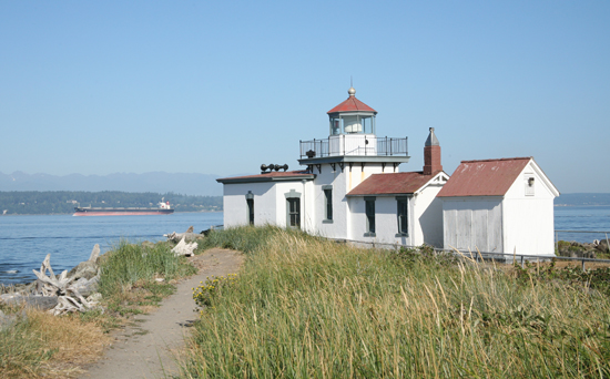
Photo Gallery
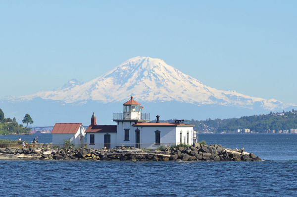

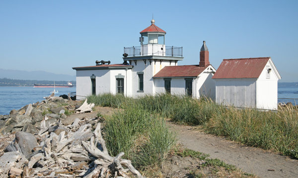
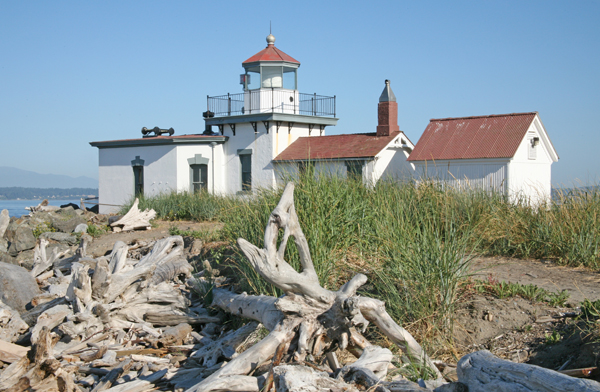
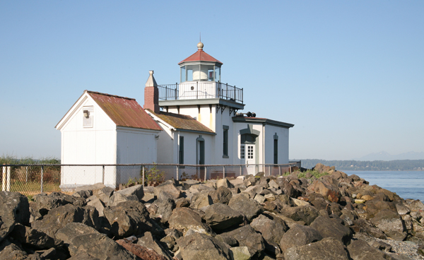
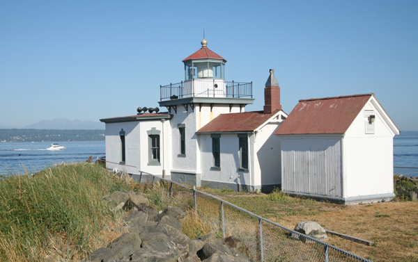
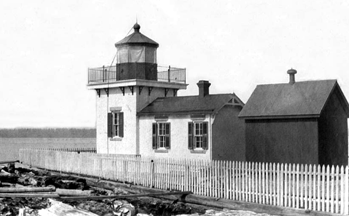


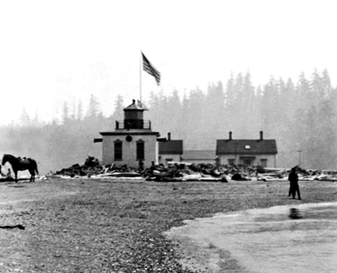
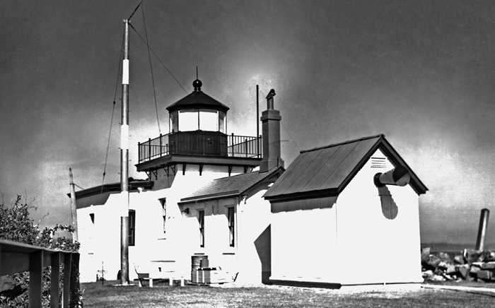


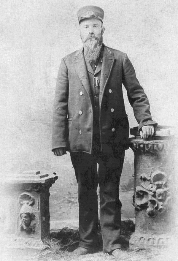
Photo Gallery
Photo Gallery
|
There is no aid to navigation in Admiralty Inlet or Pugets Sound established, or proposed to be established, by existing legislation, south of Point-no-Point; and it is highly essential that this magnificent sheet of water, which has not its equal in the world, should be so marked by fog signals as to render its navigation from Cape Flattery to Olympia possible at all times without danger to life and property. Following the inlet south from Point-no-Point, the point or spit which deserves attention is West Point. This is the first prominent point or sand-spit north of the busy town of Seattle, on the east side of the inlet (or Pugets Sound, the dividing line not clearly defined) and nearly opposite the center of Bainbridge Island. A 10-inch fog-whistle is recommended for this station. It will cost $10,000, and an appropriation of that amount is accordingly recommended.
Congress appropriated the requested amount for a fog signal at West Point on June 14, 1880, but another act, passed on March 3, 1881, made the money applicable for the establishment of a lighthouse on the point as well.
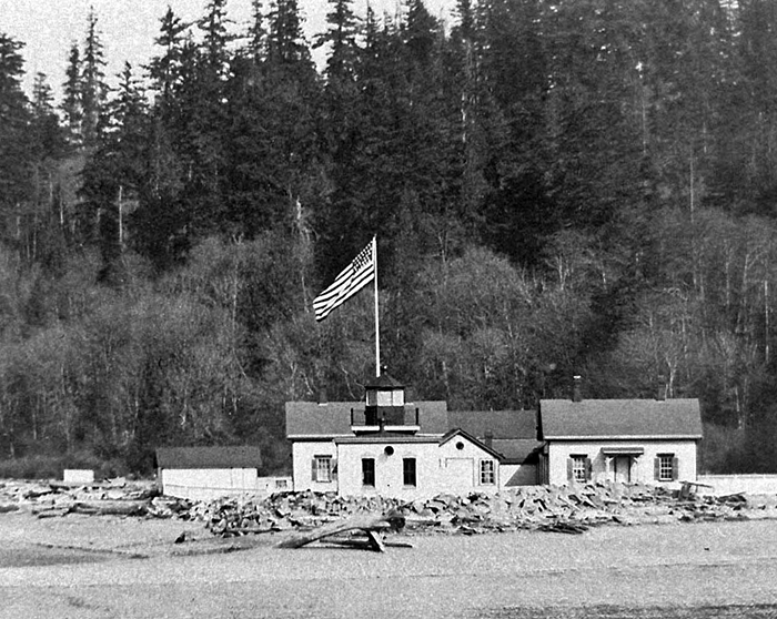
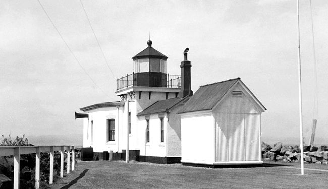
After six acres on the tip of the point had been purchased from John Leary, construction of the station commenced on July 6, 1881. A low, square, brick tower, with an attached watch room and oil room, was built at the outer end of the spit, and a pyramidal, frame tower for a fog bell was erected just to the rear of the lighthouse. The 1,600-pound bell used at the station was relocated from Cape Disappointment, where it had been in service since 1856. A five-room, one-and-one-half-story, frame cottage was constructed east of the lighthouse for the keeper.
|
Since the lighthouse commenced operation on November 15, 1881, it has guided countless vessels into Seattles Elliot Bay, located just south of the point. When the Lake Washington Ship Canal was completed just north of West Point in 1917, the lighthouse also served as a marker to the entrance of this liquid link between Puget Sound and Lake Union and Lake Washington.
After having served as an assistant keeper at Cape Flattery for eight years, Alfred W. Martin was appointed the first head keeper of West Point Lighthouse at an annual salary of $800. Archibald W. Prushaw, who had been third assistant keeper at Cape Flattery for just a short time, was made the first assistant keeper at West Point with a salary of $600. The two keepers had to share the single dwelling on the point until the office of assistant keeper was eliminated in October 1882.
In 1886, the Lighthouse Board decided to replace the fog bell by a Daboll trumpet operated by a caloric engine, and as the new fog signal would require more attention than the bell, funds were also provided to construct an additional dwelling. Work on the fog signal building and dwelling began in June and was completed on September 15, 1886. The fog signal machinery arrived in late December, and the Daboll trumpet was placed in commission on February 7, 1887. No longer needed, the fog bell was transferred to its final home at Oregons Warrior Rock Lighthouse.
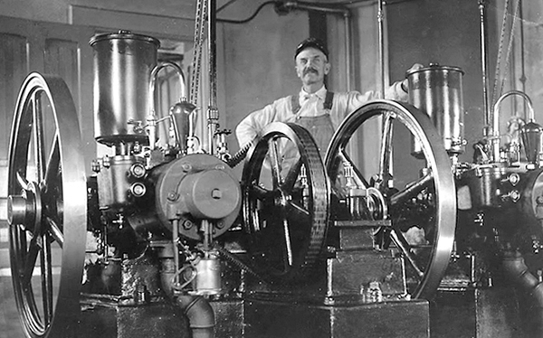
The fog signal was in operation roughly 350 hours per year, but in 1897, it logged 892 hours and consumed about seven tons of coal. In 1901, the Lighthouse Board decided that the old fog signal was worn out, and work on the brick fog signal building, attached to the west face of the light tower, began that July. The old frame fog signal building, which stood east of the lighthouse, was converted into a storehouse. The new fog signal machinery, which commenced operation on December 29, 1901, consisted of two one-and-a-half-horsepower oil engines that were connected to air compressors for sounding the Daboll trumpet. Interestingly, there have been a varying number of fog trumpets used at West Point Lighthouse. This 1916 photograph shows horns on the north, south, and west sides of the fog signal building, while an inline photograph on this page appears to show a trumpet on just the west side, and this 1944 photograph shows a fog trumpet on the east side of the oil house along with a pole for the stations new radiobeacon. The horn on the oil house was not present in this 1938 photograph.
|
The first keepers were quite isolated on the point, but they were provided a boat and a boathouse so they could row the seven miles to Seattle. In 1883, a half-mile-long horse trail was made up Magnolia Bluff to connect the station to the nearest wagon road. In 1900, Fort Lawton was opened on the bluff overlooking the station to help defend Seattle and Puget Sound.
In late November 1902, Assistant Keeper Sylvenus Shepard discovered the body of his wife on the beach near the lighthouse. A newspaper account of the discovery stated, It is believed that the woman, while despondent, drowned herself. Another tragedy struck the station on December 3, 1913, when Assistant Keeper James E. Shaw fell overboard from an open power boat, in which he was returning from Ballard with his family, and drowned. Keeper Shaw lost his balance while shifting his position to attend to the engine and fell overboard. His wife Effie and three-year-old and five-year-old children watched helplessly as the tide carried him seaward. The family had been to Ballard to obtain needed medicine, groceries, and other supplies. Keeper Shaw was transferred to West Point Lighthouse from Cape Flattery Lighthouse six months before the accident. His body was recovered in January 1914.
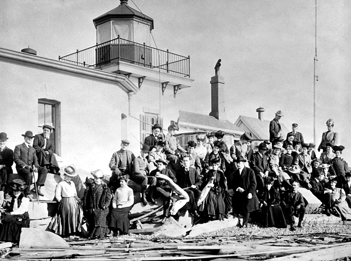
Louis A. Pettersen was in charge of the lighthouse from 1913 to 1932, after having spent four years as assistant, and received several commendations during his lengthy service. In 1916, a small sailboat capsized off the point in a squall, spilling Harry Christensen into the sound. Keeper Pettersen sprang into action, rescued Christensen from drowning, and then provided him dry clothing. The following year, Pettersen towed the disabled sailboat Mist, which had ran onto rocks near the station, to a nearby marina for repairs. Pettersen must have been a meticulous keeper as he was awarded the efficiency flag on at least two occasions for having the model station in the district. After winning this award, Pettersen was allowed to fly the efficiency flag at West Point during the succeeding fiscal year.
|
A diaphragm air horn replaced the Daboll trumpet at West Point in June 1944. This new fog signal sounded a three-second blast every thirty seconds, instead of a five-second blast every thirty seconds. Today, mariners need to key their radio mic five times on channel 81A in order to activate the stations fog horn, which will then remain in operation for thirty minutes.
Chief Boatswains Mate Christian Fritz served at the station in the early 1960s, after the Coast Guard became responsible for the lighthouse. The level terrain on the point permitted Fritzs blind wife to freely stroll the stations grounds with the assistance of her Boxer guide dog Cookie.
In 1979, the station was slated for automation, but the wish of Marvin Gebers, the keeper at the time, to have the lighthouse still be manned for its centennial came true when the automation was postponed. On November 15, 1981, Gebers climbed atop the lighthouse and celebrated its centennial by dousing it with a bottle of champagne. Gerber enjoyed his time at the station and even succeeded in adapting his telephone conversations to twenty-seven seconds of talk followed by three seconds of silence to match the signature of the foghorn.
After all the other lighthouses in the State of Washington had been automated, West Point Lighthouse finally succumbed to automation in 1985.
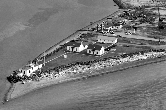
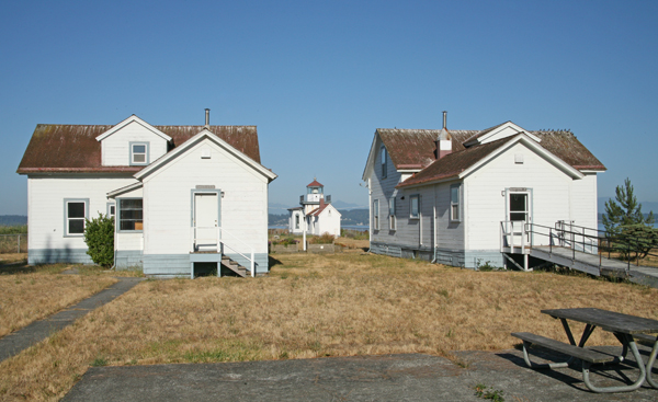
West Point Lighthouse is now part of Discovery Park, Seattles largest city park, which also includes Fort Lawton. In late 2002, West Point Lighthouse was declared surplus by the federal government under the National Historic Lighthouse Preservation Act of 2000. The City of Seattle was awarded ownership of the lighthouse in 2004, and obtained the deed to the property in 2006. Between September 2009 and the following June, lead paint was stripped from the lighthouse, and its exterior was restored as part of a $600,000 restoration of the station. Work on the keepers dwellings was compelted in 2011. Since this initial work on the property, nothing has been done to maintain or improve the station.
Keepers:
References

