Duluth Harbor South Breakwater Outer, MN 
Select a photograph to view a photo gallery
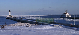

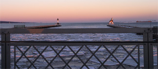
Photo Gallery

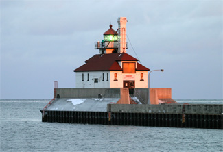

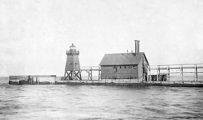

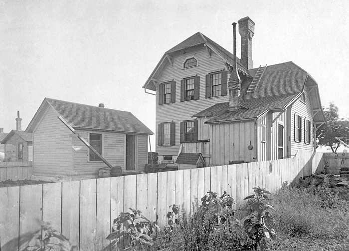


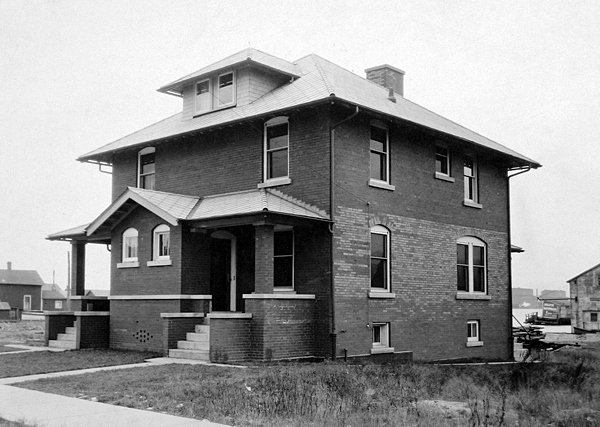


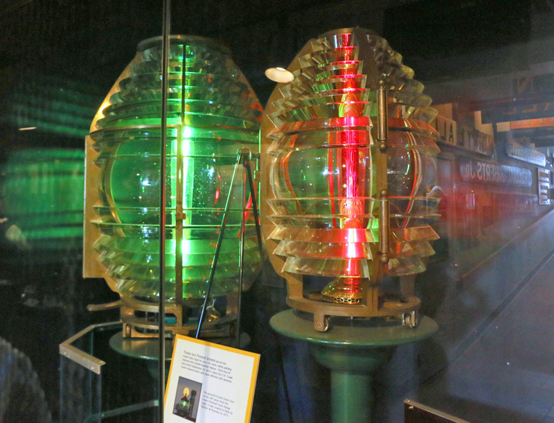
Photo Gallery
Photo Gallery
|
A railroad connecting Duluth to St. Paul was completed in 1870, and railroad authorities were eager for harbor improvements at Duluth. Railroad interests and the city joined forces to cut a channel through Minnesota Point to give Duluth direct access to Lake Superior. This work started in the fall of 1870, and the following spring the cut was opened, with the first boat passing through the canal in August 1871. Superior and the State of Wisconsin filed a lawsuit against Duluth, claiming that the new canal would decrease the flow of the St. Louis River through Superior Entry, and as a result, sediments would build up at the natural entrance. To resolve the issue, Duluth was required to build a dike across Superior Bay, between Rices Point and Minnesota Point, to prevent the St. Louis River from flowing into Lake Superior through the Duluth Canal.
After the dike was completed in 1872, Superior filed another lawsuit alleging that the dike was a nuisance and deprived its citizens of unrestricted access to the waters of Superior Bay. This case made it all the way to the Supreme Court and resulted in an opening being made in the dike to allow free navigation in Superior Bay. The dike, which had a length of over a mile, was finally removed in 1896, and a harbor committee was formed between the two cities to build up the port of Duluth-Superior as one harbor.
The Lighthouse Board asked Congress for $10,000 in 1870 to build a lighthouse at Duluth, after having received six petitions for its construction. The numerous petitioners represented: that while the harbor of Duluth is easy of access and safe during the day, or when land-marks are visible, it being without beacons, is difficult and dangerous at night when the weather is thick; that vessels are now arriving and departing daily, and with the prospect of greatly increased trade to follow the completion of the Lake Superior and Mississippi Railroad, which will be ready for through traffic in a few weeks; that the Northern Pacific Railroad Company is about forwarding the iron and other materials for building its line to Red River (over 200 miles) to this port, which will make the trade this season exceedingly large. An immense future commerce is also assured by the building of the above named two [rail] roads to this port, the most westerly point to which the great lakes can be navigated, that the nearest harbor of refuge on the south shore of the lake is at Bayfield, 75 miles distant, while the nearest safe harbor on the north shore is still more distant. Sudden storms at this end of the lake, therefore, render the harbor at Duluth one of peculiar and exceeding importance to the commerce of the lakes. We therefore pray your honorable board to take such measures as will lead to the early establishment of such lights and guards as may be necessary for the protection of the large shipping interests from all the lake ports now centering there.
|
The characteristic of the light was changed from fixed red to alternate red and white flashes spaced by ten seconds at the opening of navigation in 1885, but in 1886, the fifth-order, flashing red and white light was changed to a fixed red light of the fourth order.
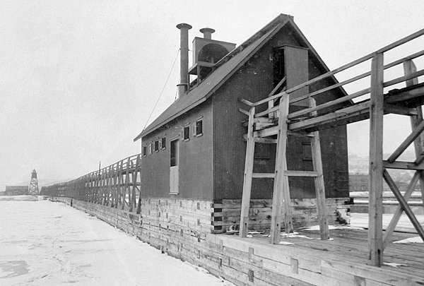
Construction of a fog signal building near the light began in August 1885, and a ten-inch steam whistle was put into operation on October 26. The frame fog signal building was covered with corrugated metal on the outside and plain sheet-iron on the inside, and the space between the studs was filled with lime and sawdust mortar. During its first decade of operation, the fog whistle was in operation an average of 472 hours each year. After residents of Duluth complained about the noisy whistle, a parabolic reflector, built in a box filled with sawdust, was installed to deaden the sound on the landward side, and no further complaints from sleepless citizens were received. Tests showed that the reflector also increased the range of the whistle out on Lake Superior from two miles to about four miles.
The Lighthouse Board requested a light on the inner end of the southern pier to form a range with the existing light starting in 1880, but it wasnt until 1889 that money was appropriated. The rear lighthouse was built in 1889 for $2,264.58 and consisted of a four-story, wooden, pyramidal tower topped by a lantern room. The lower three stories were open framework, while the top story was enclosed to form a watch room. The lantern room housed a fourth-order Barbier & Fenestre lens with ten flash panels that revolved to produce a red flash every six seconds. The light was lit for the first time on September 1, 1889.
A single keeper was assigned to the station from its establishment in 1873 until 1885, when an assistant keeper was added to help with the newly commissioned fog whistle. A second assistant was assigned to the station in 1889, when the rear range light was placed in operation.
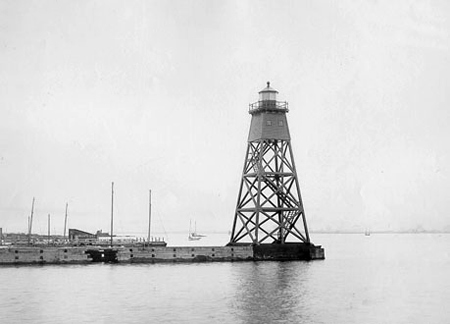
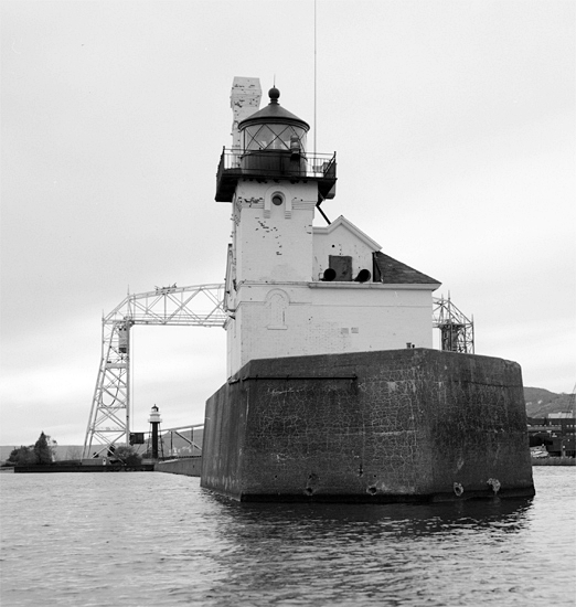
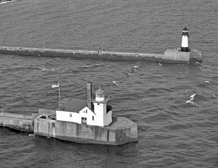
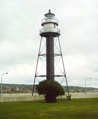
A new south pier, with a concrete superstructure, was begun in 1898 and completed in the spring of 1900. A temporary pyramidal tower was built on the outer end of this pier in 1901, and a thirty-seven-foot-tall mast set up at the piers inner end. These lights served while work on a combined fog signal and light tower and a skeletal iron tower was carried out. The new rear tower, which remains standing today, was described as a skeleton iron structure, about 70 feet high, composed of columns, sockets, struts, and tension rods, forming the frustum of a square pyramid, surmounted by an architrave supporting an octagonal gallery, a circular parapet, and an octagonal lantern, and is accessible from below by a spiral stairway inclosed in a cast-iron cylinder. The watch room and lantern of the structure are painted black and the remainder of the work white.
|
The structures fourth-order lights, transferred from their predecessors, were exhibited for the first time on September 1, 1901, and the temporary beacons were removed. A 1,150-foot tramway was laid on top of the new concrete pier, and the keepers were provided a car to enable them to reach the outer light in stormy weather. At this time, the head keeper resided in the 1873 dwelling, while his two assistants were forced to rent houses in the city at their own expense. In 1908, the assistants rent was $10 and $15 per month. The Lighthouse Board requested funds to construct a duplex for the assistants, but lacking an appropriation from Congress, the dwelling was not completed until February 1913. The two-story brick duplex cost $7,178.81, and each of its apartments consisted of a vestibule, living room, dining room, kitchenette and pantry on the first floor and two bedrooms and a bath on the second floor.
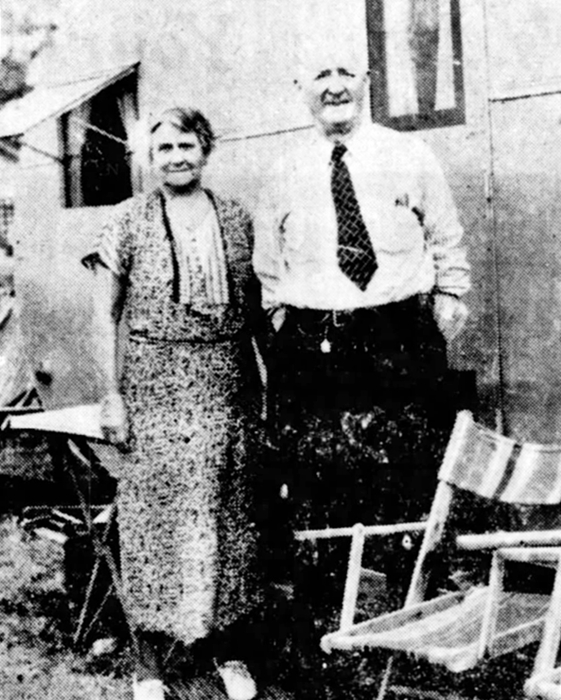
Edwin C. Bishop was the longest-serving head keeper of the breakwater lights at Duluth. Bishop began his lightkeeping career in 1897 as a third assistant at Stannard Rock Lighthouse, forty-five miles out in Lake Superior, and then took the same position at Spectacle Reef Lighthouse in 1899. He was promoted to first assistant of Spectacle Reef in 1901 and then to head keeper of that station in 1910. In 1913, Bishop became head keeper of Wisconsin Point Lighthouse, and then five or six years later was transferred to Duluth, where he served until his retirement in 1934.
Keeper Bishop saw a dramatic change in technology during his service. When I went into the service, Bishop said, we didnt have radios. Nor did we have motorboats; we traveled to and from our stations in sail boats. In a 1937 interview, Bishop recalled:
My first station was 45 miles out in Lake Superior they always put the youngsters in the isolated places. In the sailboat we used then, it sometimes took us as long as 24 hours to make the trip, and sometimes we had to turn back altogether. We left the station in early December, when the lake froze over, and did not return until spring.Now it is all different. Each station is connected by radio telephone with the central station, and ships come in and out of the harbors directed by radio. They formerly found their way in by sound, whistles and bells. Now each station is equipped with radios that can get all national programs, so theyre really no longer isolated, no matter how far from land they are.
Before the day of radio, we were truly isolated. When presidential elections came along, we sometimes wouldnt know who had been elected until the tug picked us up in December.
|
Type F diaphones were installed in the fog signal building in 1923, and soon residents of Duluth were once again complaining about the fog horn. A sound deflector was installed, and the diaphones served until 1968 when they were replaced by an electronic signal. Amazingly, local citizens had grown fond of the characteristic Bee-Oh emitted by the diaphones, and in 1976 they formed TOOT (reTurn Our Old Tone), which raised nearly $100,000 to install a diaphone signal at Duluth. In 1981, the group acquired Type F diaphones, after they were removed from the lighthouse in Kewaunee, Wisconsin. Following a nearly two-decade effort, the diaphones were reactivated on April 1, 1995 to the delight of a large crowd gathered on the piers.
Not everyone was pleased to have the powerful diaphones active once again. Hotel owners complained that the signal disturbed their guests, and the diaphones hours of operation were limited to between 9 a.m. and 9 p.m. In 2005, the three-phase power that operated the diaphones failed, and the horns fell silent. The Coast Guard refused to pay the $15,000 needed to restore the three-phase power. The city could have covered the cost of repairs and assumed responsibility for the signal, but they were scared off by the liability clause that would have held them responsible for maritime accidents related to the foghorns operation. In 2006, members of TOOT dismantled and removed what had been the last officially operating diaphone fog horn in North America.
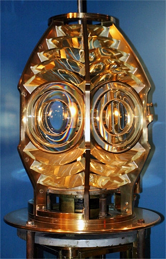
The fourth-order lens formerly used in the Inner South Breakwater Lighthouse is on display at the Lake Superior Marine Museum.
In May 2007, the skeletal inner lighthouse, deemed excess by the Coast Guard, was offered at no cost to eligible entities, including federal, state, and local agencies, non-profit corporations, and educational organizations. When no qualified group was found to take control of the lighthouse, an online auction for the property was opened on September 16, 2008. The auction closed on December 2, with the lighthouse selling for $31,000 to Steve Sola and Matt Kampf, from Duluth.
In 2014, an LED beacon replaced the active Fresnel lens in the lantern room of the front range light. This change reduced the range of the light from about sixteen nautical miles to thirteen nautical miles, but the historic lens will no longer be subjected to temperature fluctuations and ultraviolet rays that can cause the lens to deteriorate. The lens is now also on display at the Lake Superior Marine Museum. The lighthouse was added to the National Register of Historic Places in 2016.
In June 2018, the outer lighthouse, deemed excess by the Coast Guard, was made available under the guidelines of the National Historic Lighthouse Preservation Act to eligible entities defined as Federal Agencies, state and local agencies, non-profit corporations, educational agencies, or community development organizations, for education, park, recreation, cultural, or historic preservation purposes. If no qualified custodian had been found, the lighthouse would have been sold at auction. Ownership of the lighthouse was transferred to the Lake Superior Marine Museum Association (LSMMA) in 2025. Shortly after receiving ownership, LSMMA hired a consultant to complete a Historical Structures Report for the lighthouse, and a contractor was hired to remove pigeon guano, lead paint, and asbestos tile from the structure. LSMMA hopes to have the lighthouse open for tours in 2027.
Keepers:
References

