Superior Entry Breakwater, WI 
Select a photograph to view a photo gallery
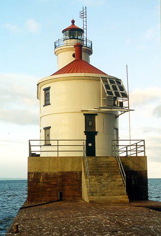


Photo Gallery

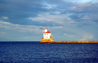
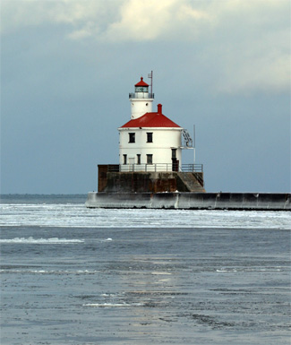
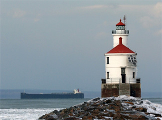
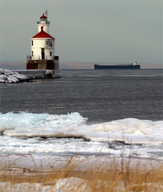
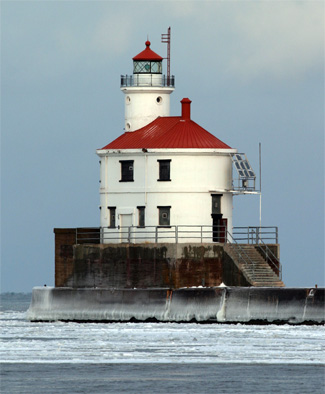
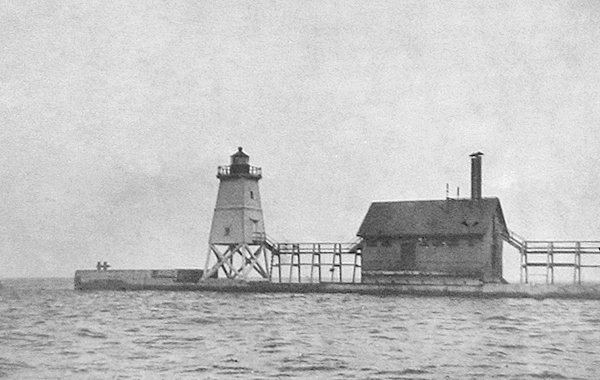

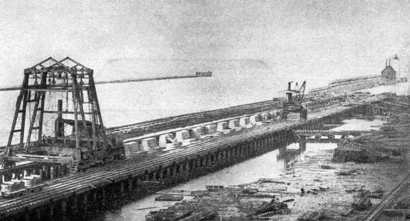


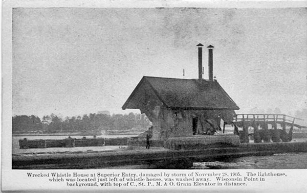
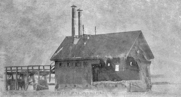

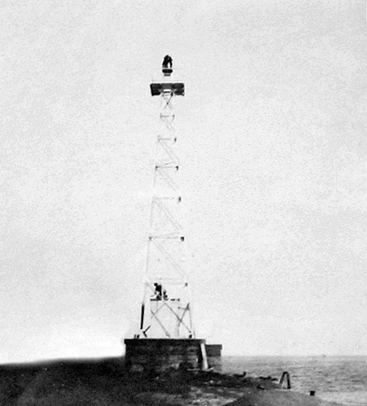


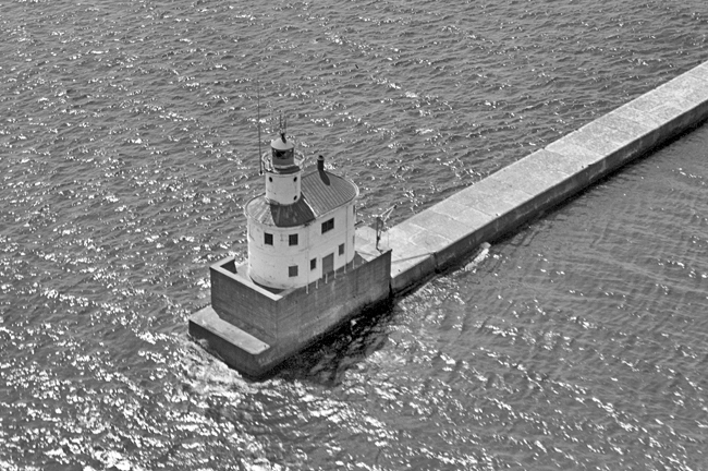

Photo Gallery
Photo Gallery
|
A lighthouse commenced operation on Minnesota Point in 1858, just five years after the completion of the bypass canal at Sault Ste. Marie that allowed vessels to easily move between Lake Superior and the lower Great Lakes. Minnesota Point Lighthouse was extinguished in 1885, after its role had been taken over by a pierhead light on the northwest side of Superior Entry. In June 1893, the pierhead light, a skeletal frame structure of twelve-inch square timbers, was moved to the pier on the southeast side of Superior Entry, where an elevated walkway was built to provide access to the light in stormy weather. The Lighthouse Board recommended that a fog signal be added to serve with the relocated light and that a dwelling be erected on the Wisconsin side of the entry for the keeper, who was still living in the dwelling at the old Minnesota Point Lighthouse. At this time, over 900 vessels arrived and cleared from Superior Bay each year, carrying commerce with a value of over $28 million.
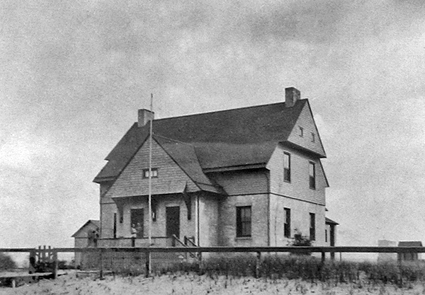
A six-inch steam whistle, housed in a twenty by forty-foot building just behind the light, was placed in operation for the first time on October 15, 1893, and a duplex, with six rooms in each of its apartments, was built for the two keepers now required to run the station. During its first decade of operation, the steam whistle was in operation an average of 394 hours each year.
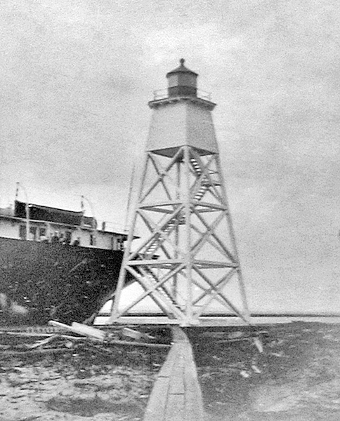
In 1898, a pole was placed on the inner end of the south pier, and a post lantern was shone from it to range with the pierhead light. This rear pole light was replaced in 1902 by a square, pyramidal frame tower, sixty-two feet high, which was painted white and topped by a black octagonal lantern room. A fourth-order lens was mounted in the lantern room and started to display its fixed white light with the opening of navigation on April 1, 1902. This frame tower had previously been used as a temporary lighthouse on Devils Island and became available in late 1901 after that station was completed.
|
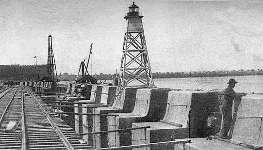
The lights on the docks and in the streets of the town of East Superior, Douglas County, Wis., back of Superior Entrance, are confusing to mariners. Some change is needed which will render the range lights of the harbor more conspicuous and more easily distinguished by vessels desiring to enter from Lake Superior.The War Department, in the progress of river and harbor improvements, is now engaged in building a concrete pier to the south of the old timber pier upon which the fog-signal and range lights now stand. After the construction of the concrete pier it is proposed to remove the crib pier, and this will of itself compel the removal of the present structures.
It is proposed to replace the present lights with two fixed fourth-order white lights varied by flashes, which will overcome the objection to the present lights.
It is estimated that it will cost $20,000 to reconstruct the range lights and fog-signal house on the permanent concrete pier now being built and for the changing of the lens apparatus of both beacons, and it is recommended by the Light-House Board.
Before the new pier was finished, a storm on November 27 and 28, 1905 washed away the front light and heavily damaged the fog signal building, rendering the steam whistle inoperable. Two-thirds of the northwest wall was destroyed and about forty tons of coal along with valuable tools and supplies were swept away. Repairs to the fog signal and elevated walkway were effected, and trestle steps were installed to provide access to the roof of the signal building, where a temporary frame lantern was placed to serve as the front light.
On June 30, 1906, Congress appropriated $20,000 for range lights to mark the new south pier, but after this appropriation, the Superior Entry project was expanded to included not only new parallel piers but also two converging breakwaters to protect the entrance. The Lighthouse Board requested an additional $25,000 to cover a light and fog signal on the southern breakwater, and three non-attended acetylene beacons to mark the piers and northern breakwater. Congress provided this amount on March 4, 1911, and work on the new lighthouse commenced that fall.
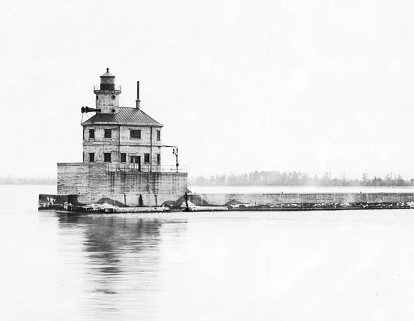
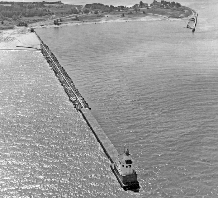
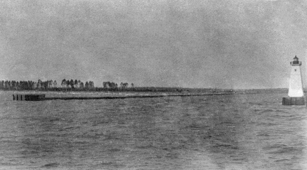
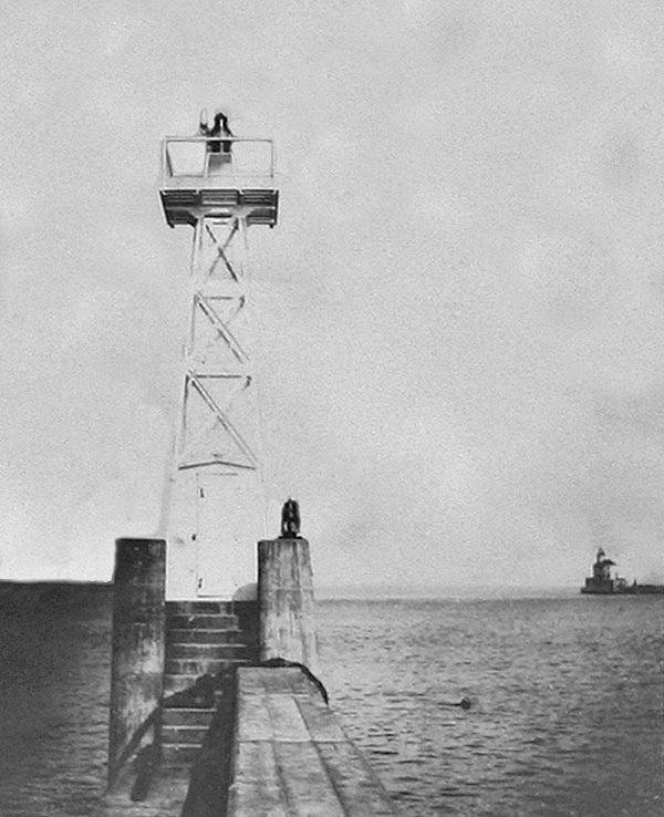
Superior Entry Lighthouse went into commission on June 30, 1913 at the outer end of the southern breakwater. This two-story, concrete structure is oval in plan and situated on a concrete pier that rises eleven-and-a-half feet above the concrete breakwater. A circular tower rises from the outer end of the lighthouse, and is surmounted by a cast-iron deck and a fourth-order helical bar lantern room, from which an occulting white light was exhibited by a fourth-order, Sautter, Lemonier, & Cie. drum lens at a focal plane of seventy feet. A clockwork mechanism, powered by a seventy-five pound weight that was suspended in a drop tube and had to be wound up every four hours, revolved a screen inside the lens to produce the lights characteristic: five seconds of light, followed by five seconds of eclipse.
|
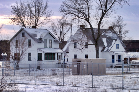
The keepers duplex onshore continued to be used as a shore residence for the keepers, and the living quarters at the lighthouse were only used in the case of emergency or inclement weather. The keepers typically accessed the lighthouse by boat, but they could also walk the breakwater, which had a steel cable running its length for the keepers safety.
An additional assistant keeper was authorized for the station, after a fourth light besides the main light on the south breakwater was established at Superior Entry. These four lights were a fifty-foot skeletal steel tower on the north breakwater, a twenty-five foot skeletal tower on the outer end of the north pier, a twenty-five foot skeletal tower on the outer end of the south pier, and a light on the inner end of the south pier. To accommodate the third keeper, a new dwelling, built of concrete and hollow tile, was constructed near the duplex in 1916. The total cost for the new lights and dwelling came to roughly $42,000.
Roger Campbell was serving as first assistant keeper of the Superior Entry Lights in February 1914, when one day he headed down the ice along the shore to hunt rabbits. When he was about seven miles from the entry, he realized the ice he was on had separated from the shore and he was being blown out into the lake. Alarmed but clear-minded, he discharged his rifle repeatedly and managed to attract the attention of three men on shore, who braved the icy waters and came to his rescue in a rowboat. As Campbell was being pulled into the rowboat, the large ice floe he had been stranded on started to break up.
A radiobeacon was established at Superior Entry in 1938 as an additional aid to mariners during periods of limited visibility.
On Monday, November 28, 1960, a powerful storm stirred up forty-foot waves at the entrance to the Duluth-Superior Harbor. Twenty-four-year-old Robert Dunno and eighteen-year-old Fred Ketola were standing watch that day as the waves pummeled the lighthouse. Dunno recorded in the stations logbook that the high seas broke through the northeast window of the radio beacon room, soaking the precious electronic equipment. The two men did all they could to keep the water at a low level in the radio beacon room and engine room so the station could continue to operate.
Besides flooding the lighthouse, the waves had also pounded a hole in the breakwater, cutting off the two men from the shore. David Simonson, the officer-in-charge, and Richard Bye, the fourth member of the crew, joined their fellow keepers to undertake the harrowing task on Tuesday morning of stringing a lifeline across the mangled breakwater. Simonson crawled over the ice-covered rocks from the shore end with a rope about his waist and Bye serving as an anchor, while Ketola crawled shoreward with a line about his waist and Dunno serving as his anchor. Once the lines were tethered together, the men could cross the gap using the lifeline for the remainder of the shipping season. The rescued pair, encased in spray-frozen clothing, requested eggs, bacon, toast, and coffee and a cigarette after successfully traversing the breakwater and reaching the crew quarters. You know, said Dunno, we took off our pants when we got across and they just stood there.
The station was automated in 1970, when a DCB 24 aerobeacon was installed in the lantern room. Shortly after the automation, Peter E. Jones was serving at the Coast Guard base in Duluth which was now responsible for the light. When Superior Entry Light was reported out, Jones and another coastguardsman took a boat over to Wisconsin Point and then walked out on the breakwater. The light was not functioning as they approached the lighthouse, but when they got up into the lantern room, it was flashing. The pair checked the spare bulbs in the automatic changer and found they were all good. Upon returning to the boat, the coastguardsman said, You know, I had the strangest feeling that someone was in the tower with us. Jones just laughed and told him not to watch so much TV.
|
Jones received the impression that he had connected with someone or something, and over the next several months, before he was transferred to another station, the light never malfunctioned again. The light and foghorn remain active today.
On May 1, 2013, the General Services Administration (GSA) announced that Superior Entry Breakwater Lighthouse was excess to the needs of the Coast Guard and was being made available at no cost to eligible entities defined as federal agencies, state and local agencies, non-profit corporations, educational agencies, or community development organizations, for education, park, recreation, cultural, or historic preservation purposes. Interested entities were given sixty days to submit a letter of interest. The lighthouse was supposed to go to auction after no suitable organization was found to assume ownership, but when the Corps of Engineers decided it did not want to issue leases of its piers to private parties, the GSA released another Notice of Availability for Superior Entry Lighthouse in June 2016.
When no interested party was identified to accept ownership of the lighthouse, the GSA initiated an online auction for the lighthouse on July 11, 2019 with a starting bid of $10,000. Nine bidders participated in the auction, which closed on August 26 with a winning bid of $159,000. The winner of the auction was soon identified as Steven Broudy, a thirty-four-year-old tech executive from San Francisco who served tours in Iraq and Afghanistan. Broudy had never seen the lighthouse in person before winning the auction, but he quickly planned a trip to inspect his new lighthouse.
My inspiration is Henry David Thoreau, Broudy explained. Im a huge fan of Walden and just the idea of finding a place to live in isolation, and just be very deliberate, has always been really inspiring to me. He plans to renovate the interior of the lighthouse so he can spend at least a few weeks there each summer. Renting the lighthouse out as a writers retreat or through Aribnb are also possibilities.
In June 2024, the GSA reoffered Superior Entry Lighthouse under the terms of the National Historic Lighthouse Preservation Act of 2000 for the third time so Steven Broudy must not have followed through with the purchase of the lighthouse.
Keepers:
References

