Cana Island, WI 


Select a photograph to view a photo gallery
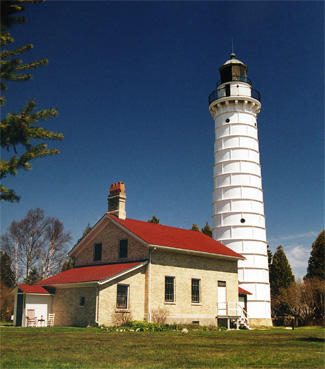
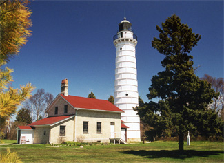
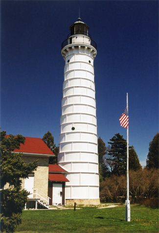
Photo Gallery


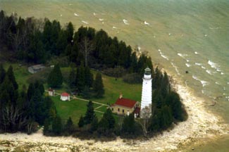
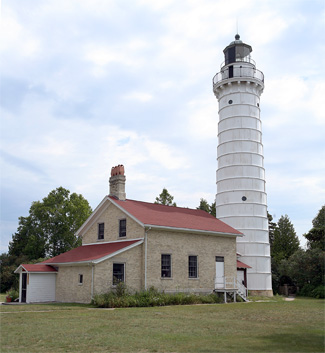
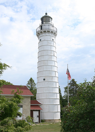


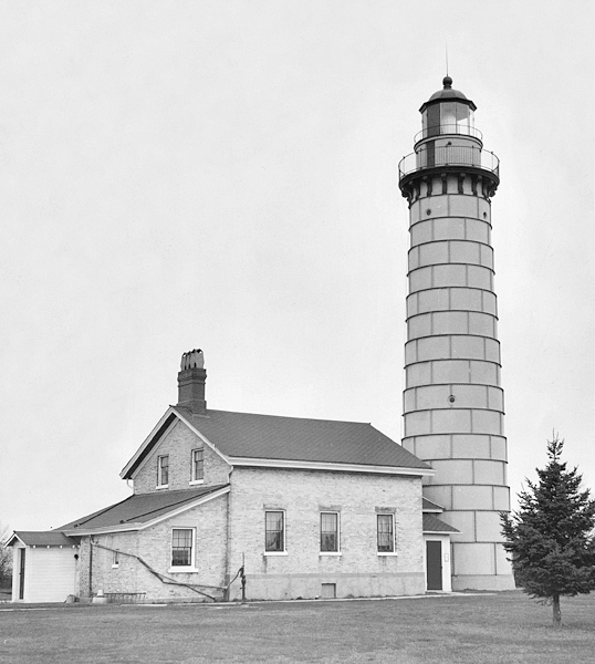
Photo Gallery
Photo Gallery
|
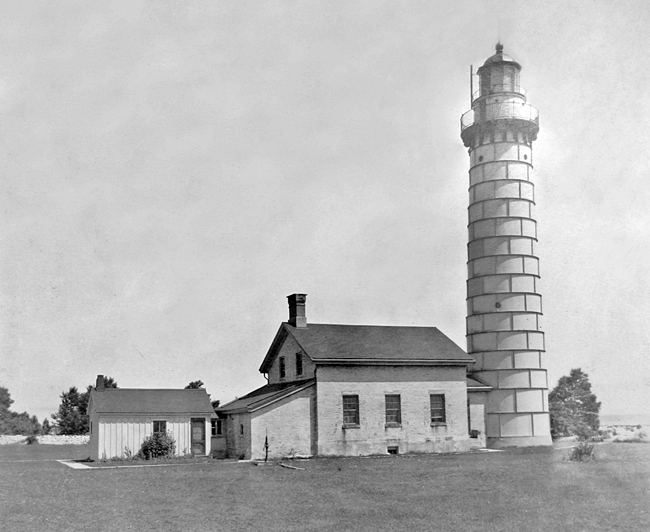
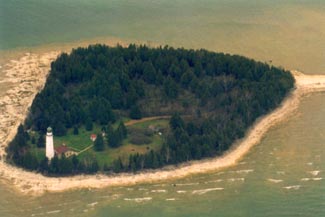
Triangular Cana Island is about nine acres in size. The lighthouse is located on the east side of the island on a section that juts into the lake, exposing the light to extreme weather. The station was built in 1869, four miles northeast of the fifteen-year-old Baileys Harbor Lighthouse. In July 1868, after President Andrew Johnson reserved Cana Island for the light, Congress approved the abandonment of Baileys Harbor Light, and the construction of Cana Island Lighthouse began.
A hole was blasted in the island for the basement of the keepers dwelling, and crews later began construction of the one-and-a-half-story dwelling. The first floor of the dwelling consisted of five rooms and was reserved for the keeper and his family, while three rooms on the second floor served as the residence for the assistant keeper.
The tower was built on an eight-foot foundation with double walls for ventilation. The outer wall narrows from a thickness of two feet at the base to fifteen inches in thickness about sixty-five feet above the foundation. The walls of the inner core of the tower are a foot thick, and six circular windows provide light during the day. The tower, which is connected to the dwelling by a passageway, was the tallest brick structure in Door County when it was completed.
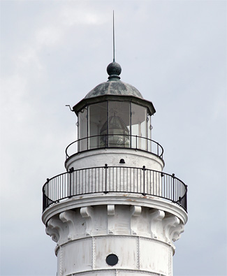
Cana Islands lantern, which consisted of a watchroom topped by the lantern room, was contracted by the Lighthouse Board and assembled in the fall of 1869, though the light was not exhibited until January 24, 1870. The lantern room is topped by a three-foot-high copper dome surmounted by a ventilator ball that allowed gases from the lamp to escape. Vertical iron bars held the thick glass panes of the ten-sided lantern together. The focal plane of the towers third-order Fresnel lens, manufactured by Henry-Lepaute of Paris, is roughly eighty-two feet above the level of the lake.
William Jackson was appointed first keeper of Cana Island Lighthouse in November 1869, while his wife Caroline was appointed assistant keeper. The Jacksons made a combined salary of a thousand dollars a year and occupied both floors of the dwelling with their daughter and four sons. On August 29, 1872, Keeper Jackson and one of his sons had to swim ashore after their boat capsized in a storm, and the family left the island shortly thereafter.
Julius Warren replaced Jackson in November 1872, and his wife Sara was also later appointed assistant keeper. Keeper Warren oversaw minor repairs of the property and the construction of a boathouse in September 1875. Julius and Sara Warren were removed from their posts in 1875, and they returned to their family farm in Clay Banks, where they resided for the rest of their lives.
William Sanderson was appointed the third keeper of Cana Island in October 1875 on a trial basis. The Lighthouse Board made the position official a year later and also appointed his wife Sarah as assistant keeper. Like the Jacksons, the Sanderson family occupied the entire keepers dwelling with their three children. The Sandersons spent their first winter at Cana Island, but shortly after his permanent appointment as keeper, Sanderson extinguished the light for winter once navigation had ended and left to spend the season with his family in Sturgeon Bay.
|
The storms made tending the light, the most important responsibility of the keeper, very difficult, but this responsibility became easier in 1882, when the Dahlia supply ship delivered mineral oil to use for the lamps in place of lard oil.
Sarah Sandersons position was terminated in October 1882, along with the assistant keeper positions at eleven other lighthouses, when Congress failed to appropriate the funds needed for the salaries. This was a severe financial blow to the Sanderson family, but two years later the Lighthouse Board reinstated the position and appointed Sandersons son Clifford to the position. The Lighthouse Board made another major decision in 1885. Due to budget cuts, the Board changed its maintenance policy and made the keepers responsible for minor maintenance at the station. Previously, visiting work crews did almost all station maintenance.
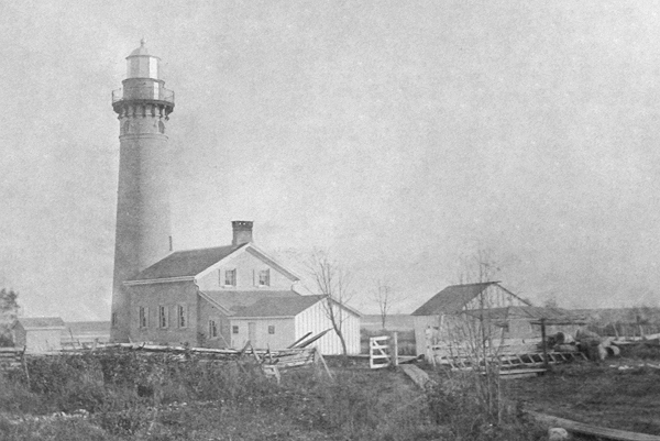
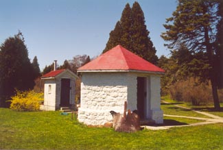
In 1884, the Lighthouse Board finally decided to take steps to prevent the occasional flooding of the station. Though construction estimates were made in 1884, the work did not begin for several years. Commander C.E. Clark arrived at Cana Island on April 18, 1890 to oversee renovation of the station. A crew of twenty-five men filled in half an acre of the lowest areas of the island with dirt and stone. They also constructed a four hundred foot breakwater parallel to the shore to stop waves from coming ashore around the keepers dwelling. A fireproof hexagonal stone oil house was also constructed to house the volatile kerosene that was being used for fuel in the lantern room, and 135 feet of one-and-a-quarter-inch iron pipe was used to make a hand railing for the tower stairs. The final improvement added in 1890 was a footbridge on the causeway to connect Cana Island to the mainland.
After sixteen years of service, William Sanderson resigned as keeper of Cana Island Light in 1891, calling Cana Island one of the most inhospitable and undesirable places that can well be imagined. The stations isolation and the water that dripped from the interior walls of the home year round were his two biggest complaints. Jesse Thomas Brown was appointed keeper in 1891 and was later joined by his wife and sons on the island. Brown made regular trips to Baileys Harbor, though he and his family did choose to stay at the station during winter. In 1893, the Lighthouse Board appointed Browns son Lawrence assistant keeper.
Rather than try to repair the deteriorating brickwork of the Cana Island tower, the engineering department of the Lighthouse Board decided to encase the tower in steel plates. Starting in June 1902, the metal plates were riveted together around the tower, and the space between the tower and casing was filled with concrete. By the end of August, the renovation was completed, and the tower had been painted white. Few visitors today realize that the tower and keepers dwelling are constructed of the same cream-colored Milwaukee brick.
In 1907, a steel rod was run through the dwelling between the first-floor joists to prevent bulging of the south wall. Also that year, 459 feet of concrete walk were poured to replace the islands old wooden walks.
|
Receipt is hereby acknowledged of your letter of October 29, 1917 reporting a visitor at your station, which is contrary to the instruction contained in District Circular Letter No. 101. You are advised that under the circumstances the regulations will be waived in your case and you are authorized to give the visitor a permanent residence.
In March 1918, Stram received an assignment as master of Lansing Shoal Lightship and was replaced by Oscar H. Knudsen. Knudsen and assistant keeper Morris Weiss spent a great deal of time clearing brush from the island and making minor repairs at the station. Knudsen is also responsible for the stone walls that still surround the station on three sides. All this work did not go unrecognized as Keeper Knudsen was awarded the Lighthouse Efficiency Flag for having the model station in the district in 1919.
On September 29, 1919, the 300-foot-long, wooden, bulk carrier Frank OConnor left Buffalo, New York bound for Milwaukee, Wisconsin with a cargo of 3,000 tons of coal. The vessels passed through the Straits of Mackinac on October 2, but at 4 p.m. the following day, a fire broke out in its bow. The fire destroyed the ships steering gear, leaving the vessel helplessly adrift about three miles off Cana Island. Keeper Knudsen had noticed the burning vessel and set off with his assistant in the stations boat to render assistance. The keepers were able to tow the OConnors crew, crammed into their lifeboats, to shore. The burning vessel eventually sank and is a popular dive spot today. An informational sign near the lighthouse tells the story of the shipwreck.
Oscar Knudsen was transferred to Grosse Point Lighthouse in 1924 so he could be near his son while he attended Northwestern University, and Clifford William Sanderson, who had served as assistant keeper to his father from 1884 to 1889, returned to serve as head keeper at his childhood home. Sanderson had previously been serving as keeper of Dunlap Reef Range, which was discontinued in 1924.
An acetylene light was installed at Cana Island in mid-November 1924, and Sanderson was informed that the station would now be closed during the winter months. In early spring, the keepers would return to the station and switch the light back over to an incandescent oil vapor (IOV) burner, which had been at use at the station since 1910. The keepers at Cana Island were also responsible for the lights at Baileys Harbor and Eagle Bluff, which had both been converted to unmanned acetylene lights.
On July 1, 1933, Sanderson was replaced by Ross F. Wright, the last civilian keeper to serve at Cana Island. Electricity came to Cana Island in 1934, when power lines were strung across the causeway to the lighthouse. The Coast Guard absorbed the Lighthouse Bureau in 1939, and Wright retired as keeper in 1941.
During World War II, the Coast Guard conducted training activities at the lighthouse. The dwelling was sealed off from the tower at this time and the south side entrance was added. After the war, the Coast Guard leased the automated lighthouse to Ralph McCarthy, who used the dwelling as a summer residence for the next twenty-five years. In 1970, control of the island and lighthouse was given to the Door County Maritime Museum.
Caretakers Louis and Rose Janda and their five children served as summer caretakers on the island for many years starting in 1977. When the Jandas arrived, windows were broken, paint and wall paper were peeling off the walls, and the chimney flues were blocked by grass and bird nests, but the Jandas patiently restored the dwelling while maintaining the grounds and welcoming visitors to the island. The Jandas were forced to leave the island after the 1995 visitor season, but the Door County Maritime Museum continued to maintain the dwelling and eventually opened it as a museum. In 2007, the island and lighthouse were officially transferred to Door County. Starting in 2008, visitors to Cana Island were allowed to climb the tower and enjoy the magnificent view that can be had from the lantern room.
Keepers:
References

