Algoma Pierhead, WI 
Select a photograph to view a photo gallery

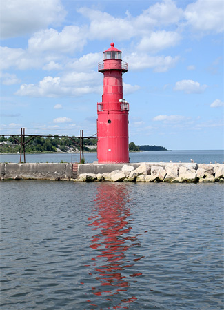

Photo Gallery


Photo Gallery
Photo Gallery
|
A project was adopted in 1875 to create a small artificial harbor at Algoma through the construction of parallel piers. Prior to this improvement, the depth of water at the mouth of the Ahnapee River was just three feet and greatly restricted commercial use of the river. Work on increasing the width of the harbors entrance from 100 feet to 200 feet by making an offset in each pier commenced in 1884. Under an act approved by Congress in 1907, a small outer harbor, enclosed by a pier and breakwater and large enough to permit turning a vessel, was constructed.
The Lighthouse Board noted in 1890 that city authorities had maintained their own light at Algoma for several years but felt that the quantity of commerce at the harbor now merited a regularly established and maintained light. The Board requested $2,500 for the construction of a pierhead tower and a post light to function as range lights on Algomas northern pier. Congress funded the project in March 1891, and the range structures were ready to be placed in operation during the summer of 1892, but the illuminating apparatus had not yet arrived.
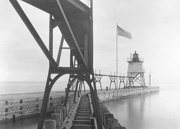
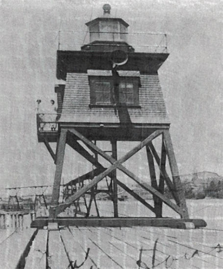
A lens lantern for the tower and a tubular lantern for the post light were finally put in place and tested on December 23, and the range lights went into service on March 1, 1893. The lower portion of the rear tower was open framework, while the upper portion, below the hexagonal lantern room, was enclosed. The tower was sixteen feet square at the base, tapered to ten-and-a-half feet at the lantern room, and was bolted to the wooden pier substructure. The tower measured thirty-five feet from base to ventilator ball, and its light had a focal plane of thirty-seven feet. The post light had a focal plane of twenty-two feet. Ole Hansen was transferred in from Chicago Harbor Lighthouse to be the first keeper at Algoma.
A bridge with stairs at each end was built to link the main north pier and the detached outer pier in 1892, and in 1895 a fifth-order lens took the place of the lens lantern. A red chimney was used on the lamp inside the Fresnel lens to produce a fixed red light. The bridge was abandoned in 1900, after over 300 feet of elevated walkway were installed on the pier and detached pier to permit the keeper to access the lights in any weather conditions.
In 1901, Keeper Gustavus Umberham transferred to Algoma from Michigans Cedar River Lighthouse with his five children, his wife having passed away at Cedar River. Umberham met and married Anna Meunier in Algoma, and they had two more children. One of these two children was Cora, who in 2008 still vividly remembered the night of February 3, 1913 when three men knocked on her familys door with a message that destroyed the happy home she had known as a lighthouse keepers daughter.
|
After having stood his watch, it was Umberhams turn to warm himself inside the cabin before relieving Adamson at the Helm. As Gus made his way forward, a heavy swell struck the boat, pitching him into the cabins door and then overboard. Hearing the noise, the other men quickly discovered what had happened and turned the boat around to search for their friend. After spending an hour circling and occasionally killing the engine to listen for any sign of their friend, the heartbroken trio returned to Algoma and trudged up the hill to break the news to Umberhams family.
Beginning in 1901, the Lighthouse Board made an annual request for $3,500 for building a keepers dwelling at Algoma, noting that the pier was on the opposite side of the river from any available dwelling and that the keeper should reside sufficiently near the lights to give them proper care. Congress finally provided the necessary funds through acts in March 1907 and May 1908. A lot for the keepers dwelling was purchased on July 9, 1908, and upon this a red brick, six-room dwelling with green shingles on its second story and gables was constructed during May and June of 1909.
On April 10, 1910, an electrically operated siren fog signal was established in the wooden tower on the pier. The engine for generating the electricity was supplied by Fairbanks, Morse, & Co. of Chicago, and the siren sounded a ten-second blast followed by ten seconds of silence when needed. Just days after the fog signal was put into operation, Louis Braemer was hired as the stations first assistant keeper. Not wanting to leave Algoma, Braemer never applied for a promotion and served as an assistant at Algoma for at least thirty years.
According to the Great Lakes Pilot for 1921, the front light was still fixed red and shown from a red post. The rear light was also still fixed red, but it was now displayed from a red square pyramidal tower, indicating the wooden tower was painted red sometime before 1921.
Carl J. Graan was transferred to Algoma as head keeper in 1923, and would hold that position longer than any other man. To placate residents annoyed by the stations fog signal, Graan devised a curved, metal-lined device that when placed around the fog trumpet, reflected most of the sound seaward. Graan received a commendation from the government for his invention, and similar reflectors were installed at other stations. The Graans had nine children, three of whom were born at the keepers dwelling in Algoma. Graans service ended in 1944, when he died of a heart attack.
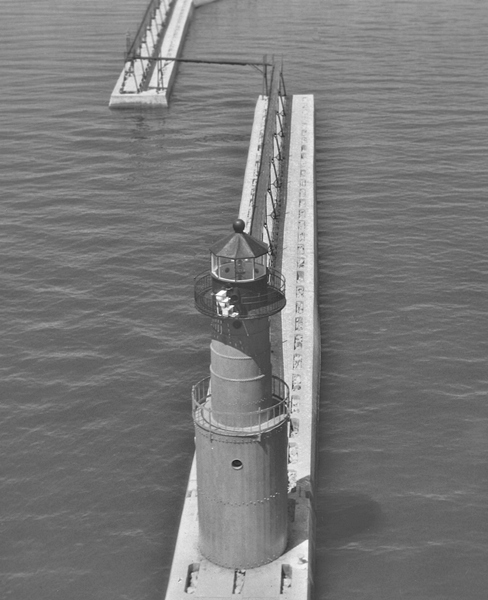
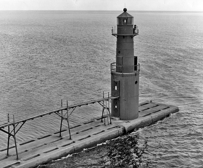
The current red, steel lighthouse was relocated to Algoma in 1932 as part of a $100,000 harbor improvement project that included capping the north and south piers with concrete. The new tower was equipped with a diaphone fog signal, operated by remote control. The lighthouse was automated in 1973.
In May 2014, Algoma Pierhead Lighthouse, deemed excess by the Coast Guard, was made available under the guidelines of the National Historic Lighthouse Preservation Act to eligible entities defined as Federal Agencies, state and local agencies, non-profit corporations, educational agencies, or community development organizations, for education, park, recreation, cultural, or historic preservation purposes. In preparation for disposal of the lighthouse, the Coast Guard hired contractors at a cost of nearly $200,000 to replace the towers foundation and windows and paint the lighthouse and attached catwalk. The work was carried out in June 2014.
The City of Algoma heard from the National Park Service in early 2015 that it was the sole applicant for the lighthouse and would likely be awarded the property.
In 2019, the Coast Guard removed the historic Fresnel lens from the tower and replaced it with an LED beacon. After being restored, the Fresnel lens was placed on exhibit at Milwaukees North Point Lighthouse.
In May 2026, the Roen Salvage Company of Sturgeon Bay began the reconstruction of Algomas north pier. The historic steel catwalk and lighthouse were removed as part of the project, but the plan is only to return the lighthouse to the pier at the end of the two-year undertaking. A Save the Algoma Catwalk Committee was formed to salvage the catwalk and restore it once the pier is rebuilt. Contributions to help save the catwalk can be made at savethecatwalk.com.
Keepers:
References
