Sheboygan Breakwater, WI 
Select a photograph to view a photo gallery
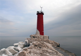


Photo Gallery

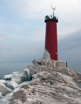
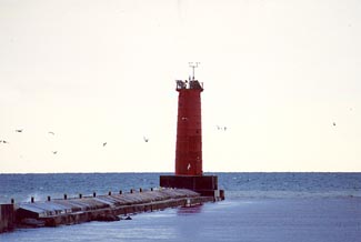
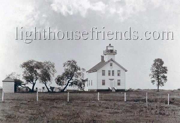
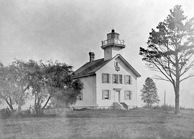


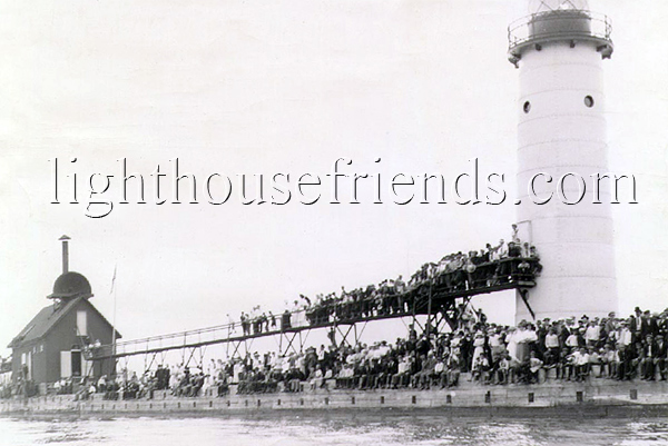

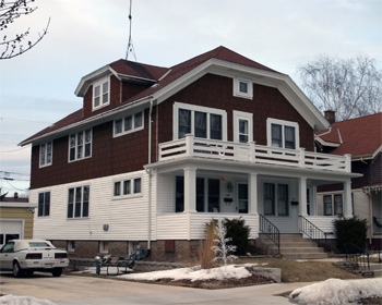


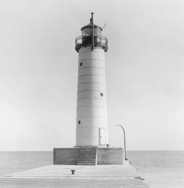
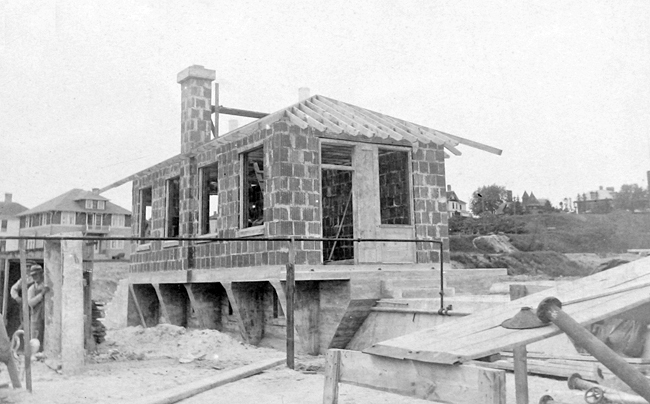

Photo Gallery
Photo Gallery
|
Chipewagan river falls into the lake about twenty miles south of Manitowoc. This stream is large enough to admit being formed into a fine harbor; and should there be an appropriation made for that purpose, I am satisfied it would be of general benefit to navigation. I did not hesitate to recommend the erection of a light-house at this point, believing as I did that there must soon be large towns at the mouths of all rivers on the lake shores where harbors can be erected.
The lighthouse built at Sheboygan was very similar to the other three lighthouses approved for Wisconsin in 1837 and consisted of a conical brick tower accompanied by a brick, one-and-a-half-story keepers dwelling. The thirty-foot-tall tower tapered from a diameter of twelve feet at its base to six feet six inches at its lantern room, from which lamps and reflectors projected a light seaward at a focal plane of eighty feet above Lake Michigan. The lighthouse commenced operation in 1839, and a fifth-order Fresnel lens was installed in its lantern room in 1857.
The first keeper of the lighthouse was Stephen Wolverton, who a 1910 edition of the Sheboygan County Historical Review described as follows. He was a florid-faced, middle aged man from Maryland. It denotes the general condition of the colony to recall the fact that Woolverton, with his government salary of $365 a year, was probably the most affluent person in the county, and regarded as a sort of capitalist who could afford to dress and live in a more sumptuous manner than the others. With the exception of the lighthouse keeper the settlers were all people who earned their daily bread by daily toil.
Built on a bluff known as North Point, roughly one mile north of the river, Sheboygan Lighthouse was being threatened by erosion in the late 1850s, prompting the Lighthouse Board to have a replacement lighthouse built nearby in 1860. This new structure consisted of a frame keepers dwelling with a lantern set atop on end of its pitched roof.
Due to a sandbar at its mouth, the Sheboygan River supported very little commerce until harbor improvements were begun in 1852, under the direction of the harbor commissioners of the town and county of Sheboygan. By 1854, parallel piers, 1,000 feet long and 175 feet apart, had been extended into Lake Michigan. The federal government took over the harbor improvements in 1866 and extended the piers lakeward. Pier lights were maintained locally until 1873, when the federal government constructed a lighthouse on the north pierhead.
Work on the lighthouse commenced in September 1873, and its fixed red light, produced by a sixth-order Fresnel lens at a focal plane of thirty-two feet, was exhibited for the first time on December 1, 1873. This open framework tower, painted white, was twelve feet square at its base and tapered to eight feet square at its octagonal lantern room. An elevated wooden walkway allowed the keeper to access the tower in inclement weather.
|
The pierhead tower was destroyed by fire on March 17, 1880, but a new tower was quickly erected and a light was exhibited from it on June 22 of that year. As the piers were extended over the years, the pierhead light was relocated lakeward and extensions were made to the elevated walkway. In 1884, the tower was moved 460 feet, and in 1889 it was moved another 200 feet seaward. Steamers owned by the Goodrich Transportation Company tore four of the walkways wooden support posts from the pier in 1891, and the company was billed for repairs.
Keeper Amos Carpenter was in charge of the pierhead lighthouse from 1866 to 1903, and a harrowing night he spent in the tower in 1892 was recounted in The Milwaukee Journal:
Lighthouse keeper Carpenter, of Sheboygan, spent New Years night in the lighthouse as is his custom during storms, in order to keep the lights in good condition. On this occasion the high wind raised a tremendous sea and the in-rolling waves striking the end of the pier dashed the water over the lighthouse and against [its] sides, and together with the driving snow and sleet froze hard upon its surface, so effectually sealing up and fastening the door by which the house was entered that it could not be opened in the morning from the inside. His family thought he was busy and it was only after twenty-four hours of imprisonment that he was released.
A lens lantern light was established on the outer end of the pier on April 25, 1892 to form a range with the light exhibited from the framework tower. Two years later, an elevated conduit was erected on the north pier so the keeper could run a lantern out to the end of the pier to serve as the front range light without having to leave the rear tower. The conduit was damaged by a schooner during a storm in 1895 but was immediately rebuilt.
The Lighthouse Board requested funds for a fog signal for the north pier starting in 1892, but it took repeated requests before Congress appropriated $5,500 for the project on March 2, 1895. Prior to constructing the fog signal on the pier, the conduit light was discontinued on September 30, 1895, and the pierhead tower was moved 230 feet to the outer end of the pier. The Lighthouse Board gave the following description of the ten-inch steam fog whistle that commenced operation on March 5, 1896.
The plant consists of duplicate, square, open-bottom marine boilers and two Crosby automatic signals, contained in a substantial frame building, sheathed and covered inside and outside with iron. The frame is filled in with sawdust and lime filling. The building stands on a timber substructure, raised 5 feet above the top of the pier.During its first three months, the steam whistle was in operation some 155 hours and consumed about thirteen tons of coal and half a cord of wood.
|
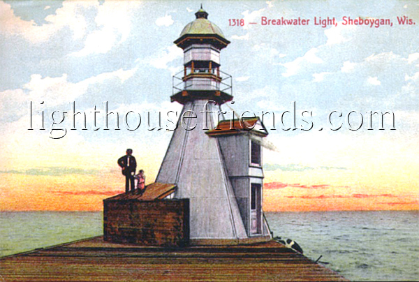
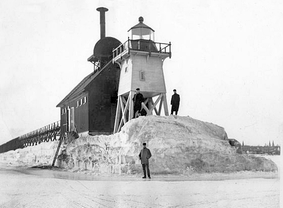
On October 24, 1900, a fixed red lens lantern was displayed from a wooden post on the southeast end of the detached breakwater, that ran at a 45° angle off the end of the north pier. To protect the light, a V-shaped pier consisting of six courses of eighteen-foot-long, twelve-inch-square timbers was constructed on the exposed side of the breakwater. In 1902, metalwork was delivered at Sheboygan to construct an enclosed tower for the breakwater light. This lighthouse resembled an inverted funnel topped by a lantern room, and its light was first displayed on November 14, 1902.
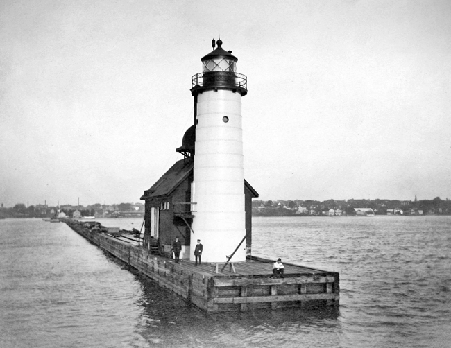
The pierhead light was upgraded in 1904, when a fifty-foot-tall, circular tower, made up of steel plates riveted together, was erected atop a new concrete foundation at the outer end of the north pier. A 1,700-foot-long elevated metal walkway was also installed that year, in placed of the old wooden walkway. On August 29, the lighthouse at North Point was discontinued, and its fifth-order Fresnel lens was placed in the new tower. The public was invited to visit the new tower on Sunday afternoons, and on September 25, 1904, over 100 visitors were received by the keepers. After a fierce gale on November 28 drove the tower thirty feet north, leaving three feet of the tower projecting off the pier, a new sea wall was constructed to afford more protection for the tower.
A new two-story, three-apartment, brick dwelling was built for the keepers of the Sheboygan lights in 1911, using $6,000 that had been appropriated for this purpose on June 30, 1906. The dwelling was located near the foot of the north pier and described as follows:
Facing the front, the left-hand side of the house contains the keepers quarters, consisting of one large room in the basement; kitchen, pantry, dining room, and parlor on the first floor; and three bedrooms with closets and a bathroom on the second floor. The right-hand side contains one set of quarters over the other for the assistants. Each assistant has a separate cellar space and a combined kitchen and living room, a pantry, bedroom or sitting room, a bedroom, and a bathroom on one floor.No longer needed, the old North Point Lighthouse was sold, and its owner relocated it a few blocks inland in 1916.
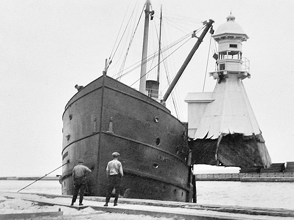
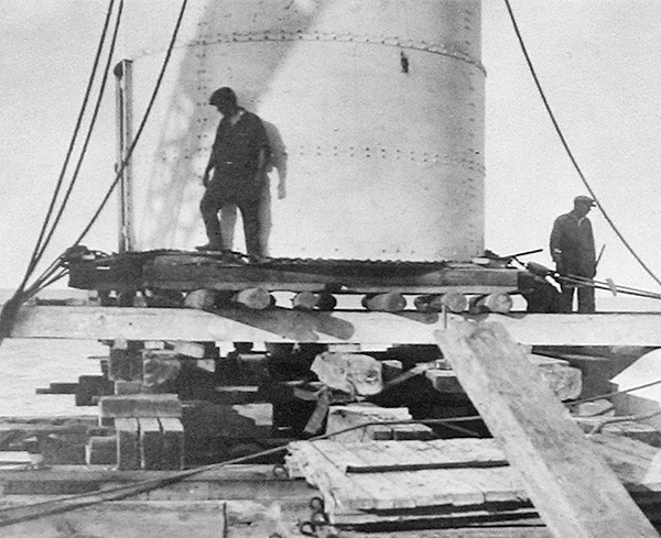
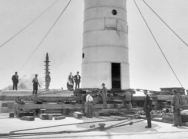
As part of a plan to create a stilling basin at the harbor entrance, most of the north pier was removed and a new north breakwater was constructed, necessitating the rearrangement of the harbor lights. The pagoda-style lighthouse was removed from the breakwater in June 1915 by the tender Hyacinth, while the tower on the wooden north pier was jacked up and placed on square timbers. The steel tower, which weighed about thirty tons, was relocated without dismantling it from the north pier to the new concrete north breakwater on August 19, 1915 using a scow. In its new location, the lighthouse showed a flashing red acetylene light every four seconds.
|
While the breakwater light served as the primary light at Sheboygan, a standard thirty-one-foot steel skeleton tower, which displayed a flashing white light every three seconds, was erected atop the south pierhead, and an iron post, from which a fixed red light was displayed, was placed on the truncated north pier. This new system of lights went into operation on November 24, 1916 and cost $22,634,
On June 12, 1919, an article in the local newspaper told of eighteen-year-old Francis Wolf, who was riding his bicycle out to the lighthouse late at night to meet some friends when he plunged off the end pier. Fortunately, he was a good swimmer and was able to pull himself out of the water. The article noted that the breakwater was not a public thoroughfare for bicycles and such a practice was prohibited by law. Another act that local miscreants were warned against repeating was inscribing obscene words and poetry unfit to read on the lighthouse with their jack knives. Keeper Ingvald Olsen reported that this had become a common practice and warned that the vicious practice must cease, or the guilty parties would be prosecuted to the fullest extent of the law.
In February 1924, a group of boys attempted to cross a strip of thin ice to reach a large ice cake floating in the harbor at Sheboygan. Two boys made it to the little iceberg, but a third plunged through the thin ice into the freezing water. Though soaked and frightened, the boy was able to clamber out of the harbor and join his friends on the large piece of ice. Keeper Ingvald Olsen and Arderll E. Pierce, his helper and son-in-law, were walking along the shore after having serviced the breakwater lighthouse when they heard the boys cry for help. The keepers tied a long rope to a sled one of the boys had left on shore and then pushed the sled across the strip of thin ice to the stranded boys. The water-soaked boy was the first to try crossing on the sled and was the only one of the three to break through the ice during the rescue. Fortunately, he was able to cling to the sled and was soon pulled onto the thicker shore ice by the keepers.
A Class D marker radiobeacon was established at Sheboygan in 1942 as an additional navigational aid for mariners. At some point, the lantern room was removed from Sheboygan Breakwater Lighthouse. The lighthouse still emits a three-second blast every thirty seconds when needed, but the characteristic of its light has been changed to a flashing white light every four seconds. The top of the tower is now also home to a NOAA weather station.
In July 2025, Sheboygan Breakwater Lighthouse, deemed excess by the Coast Guard, was made available under the guidelines of the National Historic Lighthouse Preservation Act to eligible entities defined as Federal Agencies, state and local agencies, non-profit corporations, educational agencies, or community development organizations, for education, park, recreation, cultural, or historic preservation purposes. Interested parties were given sixty days to submit a letter of interest.
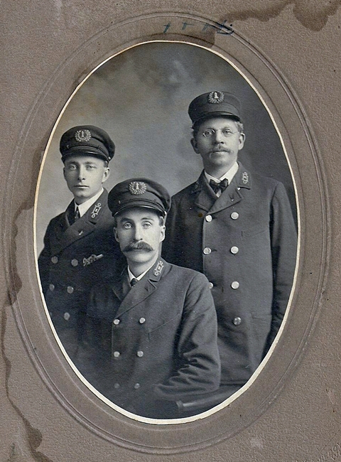
Sheboygan Lighthouse Head Keepers: Stephen Wolverton (1840 1845), Elijah F. Cook (1845 1848), Alexander H. Edwards (1848 1849), Thomas C. Horner (1849 1853), Godfrey Stamm (1853), Sylvester Remington (1853 1854), Godfrey Stamm (1854 1857), Addison Manville (1857 1861), Nelson G. Stickles (1861 1865), Lanty Brazelton (1865 1869), William G. Mallory (1869), Eva Pape (1869 1885), Peter Danielsen (1886 1903), Bernhard Pizzalar (1903 1904), William P. Larson (1904).
Sheboygan Breakwater Lighthouse Keepers
References


