Milwaukee Breakwater, WI 

Select a photograph to view a photo gallery

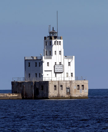

Photo Gallery
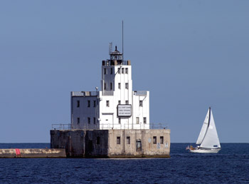


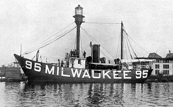
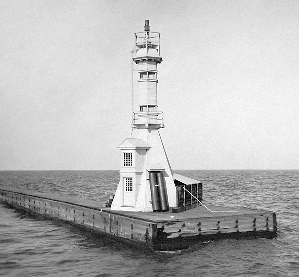

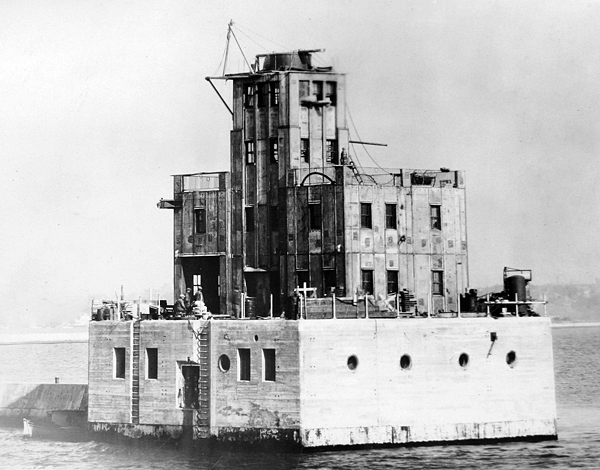

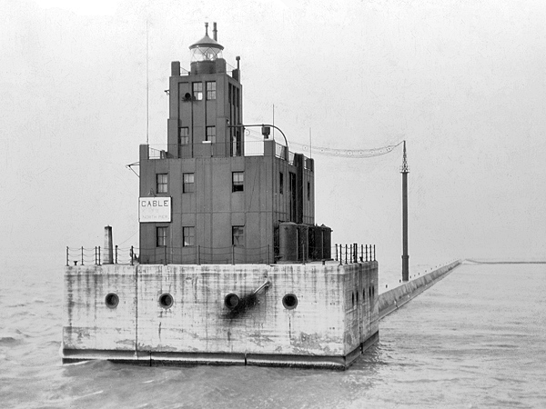

Photo Gallery
Photo Gallery
|
The Lighthouse Board repeated its request for a fourth-order light and a companion fog signal for the breakwater in 1900 and 1901, and then in 1902, it modified its recommendation, asking instead for $100,000 for a third-order light. This more powerful light was to have a focal plane of at least 105 feet and would allow North Point Lighthouse to be discontinued. The Board repeated its request for $100,000 in 1903, 1904, and 1905, before being granted $50,000 toward the construction of a light and fog-signal on the south end of the breakwater in 1906, provided the total cost of the project did not exceed $100,000. A second $50,000 was appropriated in 1907, but after $75,000 was awarded for a lightship at Milwaukee in 1908 and $10,000 was allocated for the restoration of North Point Lighthouse in 1909, the Lighthouse Board decided not to pursue the construction of a major light for the breakwater. The $100,000 was accordingly carried to the surplus fund.
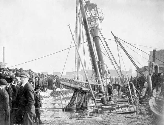
In 1902, while the Lighthouse Board was waiting for funding for a new breakwater light, metalwork was delivered to Milwaukee, and the post light at the southern end of the breakwater was enclosed in a white, hexagonal structure. Work on this new lighthouse, a white pyramid, surmounted by a shaft, having two glazed belts forming the lanterns, surmounted by a dome, was completed in October, and its lights were activated on the twenty-fourth of that month. The upper light was shown at a focal plane of forty-and-a-half feet and the lower light at thirty-two feet.
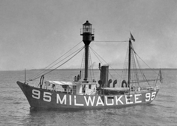
Under a $74,558 contract, Racine-Truscott-Shell Lake Boat Company built Milwaukee Lightship, (LV 95/WAL 519) in 1911 1912. The 108.5-foot, steel-hulled vessel sank at the contractors docks in Muskegon, Michigan on December 26, 1911, and was not raised until February 20, 1912. The steam screw lightship was equipped with a lantern atop its foremast in which a revolving parabolic reflector and incandescent lamp served as the illuminating apparatus. After MILWAUKEE was painted in white on the lightships red hull, the vessel took up its station three miles offshore from the breakwater on November 1, 1912. The steel foremast was hollow and equipped with an interior ladder that allowed the light to be service without exposing a person to the weather.
In the 1920s, a breakwater was extended from the southern shore of Milwaukee Bay to form an enclosed outer harbor at Milwaukee. The Commissioner of Lighthouses requested $229,800 in 1923 for establishing aids to navigation and improving existing aids at Milwaukee, noting that upon the completion of the work Milwaukee Lightship, which cost $19,000 to maintain each year, could likely be discontinued. The main breakwater entrance would be located directly offshore from the mouth of the river, and would be marked by a major lighthouse on the southern end of the northern breakwater and a minor light on the northern end of the southern breakwater. Besides these lights, minor lights were also placed to mark two other entrances through the breakwater: the northern entrance, and the southern entrance.
|
The Annual Report of the Commissioner of Lighthouses provides the following detailed description of Milwaukee Breakwater Lighthouse.
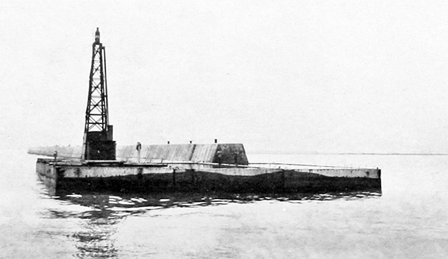
The main light is located at the south end of the north breakwater in 34 feet of water. It marks the north side of the main entrance.This work was made necessary by the extension of the breakwater to inclose an outer harbor with a restricted entrance. The great importance of this entrance required a station and signal of high class. The main light is located at the south end of the north breakwater in 34 feet of water. It marks the north side of the main entrance.
Structure: The foundation pier, inclosing a basement, is of reinforced concrete, 54 by 60 feet, 20 feet high above water, and rests on a subfoundation formed by three reinforced concrete caissons, each 20 by 54 feet, 21 feet 3 inches deep, standing side by side on a stone fill 4 feet deep over a bottom of natural clay, and above these caissons a reinforced concrete slab 54 by 60 feet and 7 ½ feet deep. The slab forms the floor of the basement, and also serves to join the three caissons together. The outside walls of the basement are 30 inches thick and the main decor or basement roof is 12 inches thick, supported by the outside walls and interior steel columns. The building above the main deck is 43 feet 2 inches by 29 feet 5 inches, of structural steel framework covered with steel plating, and has a flat concrete roof. A square tower, of similar steel construction, rises two stories above the roof of the main structure, and is surmounted by a fourth-order cast-iron lantern, the focal plane of which is about 67 feet above the water. The main deck slab and roof slab are waterproofed with asphaltic membrane, protected by a concrete slab with asphalt expansion joints. The basement is occupied by fog-signal machinery and heating plant and rooms for storage of fuel oil and other supplies. The first floor contains a boat room, kitchen, living room, and dining room. The second floor contains four bedrooms, closets, and bathroom.
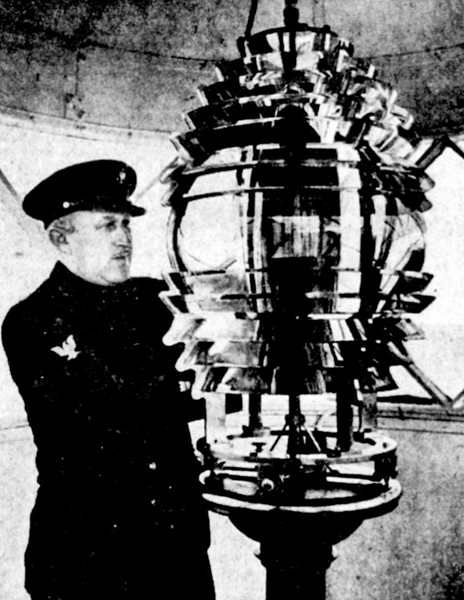
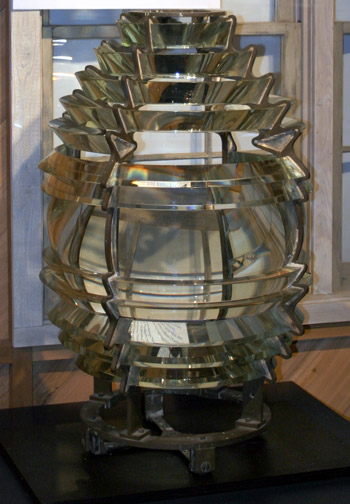
Illuminating apparatus: The lantern is provided with a fourth-order fixed lens, illuminated by a 500-watt electric lamp and red screen candlepower of beam 5,000. A commercial sign flasher provides the occulting characteristics of the light.
Fog signal: A type F diaphone is installed in the fourth story or watch room of the tower just below the lantern. Commercial current transmitted by submarine cable furnishes current for the air compressor. Oil-engine-driven compressors provide emergency service in case of failure of the commercial current supply.
Additional equipment: this station is electrically operated throughout. Commercial current is transmitted to the station at 480 volts furnishing current at 110-volts for the radiobeacon tower and dwelling lights, and at 440 volts for the air compressors. This station is provided with a radiobeacon with 200-watt transmitter, the emergency current supply for which is furnished by a gasoline-driven generator. Telephone connection with the city system is maintained through wires carried in the submarine power cable.
Other improvements in aids in this project include acetylene lights at Milwaukee Entrance South Side and Milwaukee South Pierhead; installation of a 300-watt electric lamp in the fifth-order lens at Milwaukee Pierhead; modernizing the dwelling for the North Pierhead Light and North Point Light and changing the fourth-order fixed lens at the latter station to a fourth -order lashing lens with a 500-watt lamp.
Cost: The complete cost of Milwaukee Breakwater Light Station was $150,939, and of the whole project $184,950.
|
George Rogan was an assistant keeper at the pierhead and harbor lights for nearly twenty years before being placed in charge of Big Point Sable Lighthouse in 1936. In August 1926, George Rogan, Jr., Keeper Rogans five-year-old son, was watching workmen make repairs to the pierhead fog signal when he fell into the water and drowned. Nine years later, the Coast Guard had to rescue Richard and Charles Rogan, sons of Keeper Rogan, along with four other boys, when their rowboat was caught in a squall near the breakwater lighthouse. The Coast Guard also rescued three other vessels near the breakwater that day when the seas proved too much for amateur sailors.
Michael M. Rotta served as an assistant keeper at North Manitou Lighthouse before being transferred to Milwaukee in 1928. He was keeper of Milwaukee Pierhead Lighthouse for several years before being placed in charge of all the lights in Milwaukee in 1941. In April 1937, while he was keeper of the pierhead light, his six-year-old son Michael, Jr. and his eleven-year-old brother Richard were returning home from school when Michael, Jr. was run over. The boys were crossing a street when a truck and trailer turned the corner, and Michael, Jr. was struck by a projecting trunk and knocked under the wheels. Keeper Rotta received word of the accident while working at the lighthouse, but by the time he reached the hospital his son, who wanted to be a lighthouse keeper when he grew up, had died.
On May 21, 1952, Keeper Rotta was painting Milwaukee Breakwater Lighthouse when tragedy once again touched the Rotta family. Alfred Schreiber was an assistant keeper at the time and was painting North Point Lighthouse when he heard about the accident. The Chief and Dick Skolwig were on duty at the Lighthouse that fateful day, recalled Schreiber. No one knows exactly what happened. The left hand tackle became unhooked at the top railing and the Chief fell to the concrete crib in front of the propane tanks and doorway. He died there of massive injuries. It was surmised that he attempted to climb off the platform, by shinning up the suspended tackle. Which was a common practice. The upper block was not moused. He must have inadvertently unhooked it, and the heavy weight of the staging pulled him off.
Jack Eckert was assigned to Milwaukee Breakwater Lighthouse in 1955, at which time the station was staffed with four coastguardsmen. The men served three-days on and three-days off, and two of them were always at the lighthouse, where they stood watches of twelve-hours on and twelve-hours off. Their main duty was to monitor the timing of the radiobeacon and the distance-finding blast of the foghorn. Each day, they also had to clean the cobwebs from the lantern room, where spiders came in all sizes, shapes, and colors. Spider bites on the station were just a way of life.
Mr. Uihlein of Schlitz Brewery, who had provided the station with a large black and white television set just before Eckert began his duty at the breakwater, also offered to provide the station with beer, but that offer was politely declined by the officer-in-charge. The Milwaukee Braves were having a good year in 1955, and their televised baseball games were a big hit at the station. Besides the television, Eckert filled his free time taking correspondence courses and keeping an eye on fishermen near the station, who would sometimes climb the steel ladder up to the lighthouse and enter announced using their taxpayer rights.
|
In June 2011, Milwaukee Breakwater Lighthouse was declared excess to the needs of the United States Coast Guard and made available to eligible organizations under the provisions of the National Historic Lighthouse Preservation Act of 2000. Qualified entities were given sixty days to submit a letter of interest and were required to obtain permission to access the lighthouse from the U.S. Army Corps of Engineers, which owns the pier on which the lighthouse sits. Three nonprofit groups, Optima Enrichment, the University of Wisconsin - Milwaukee (UWM), and Mt. Zion House, submitted an application for the lighthouse, but after a tour of the structure, UWM dropped out, and Optima Enrichment and Mt. Zion House decided to combine their efforts. In September 2013, the lighthouse was awarded to Optima Enrichment. We are absolutely thrilled to be entrusted with the lighthouse and the restoration of this icon of our harbor, said Randall Melchert, co-founder of Optima Enrichment. The view of both the Milwaukee skyline as well as Lake Michigan (from the lighthouse) is a spiritual experience that we want to share with our community and tourists alike. We are hoping to open it to the public for events like Doors Open Milwaukee. We want to open it for events and sightseeing for people to appreciate the maritime history of Milwaukee.
Chamberlin Group will be the project development manager for the restoration of the lighthouse, which is expected to cost up to $2.5 million.
A support group called Friends of the Milwaukee Breakwater Lighthouse was formed to raise money for the restoration of the lighthouse. According to a local newspaper account in 2016, little progress had been made in restoring the lighthouse. A follow-up story in 2024 reported that there had been no progress made in restoring the structure and that efforts to contact the owner of the lighthouse went unanswered.
Keepers:
References


