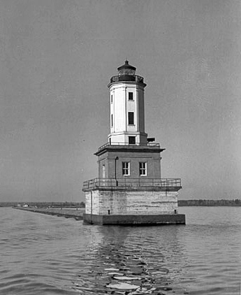
Keweenaw Waterway Lower Entrance, MI 
Select a photograph to view a photo gallery

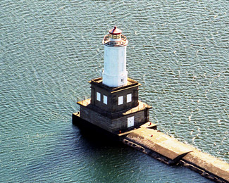
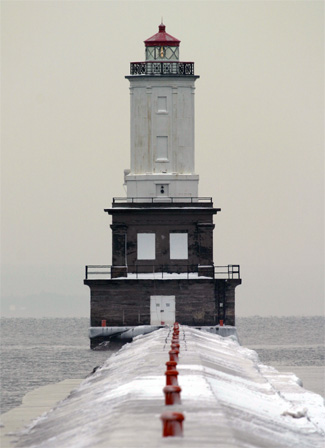
Photo Gallery
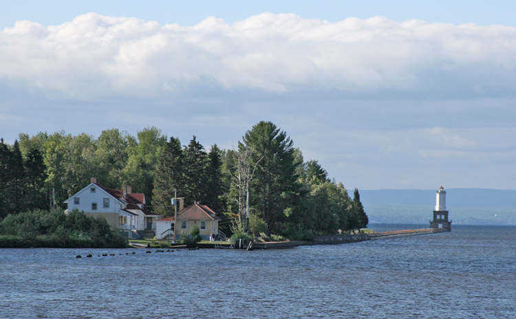


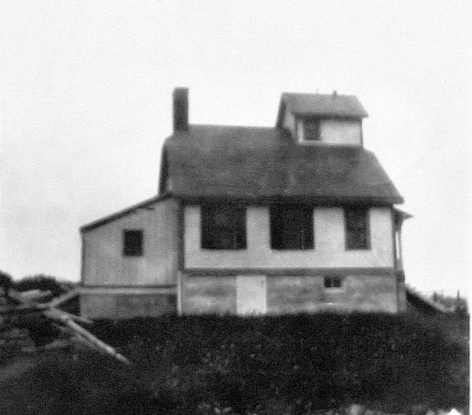


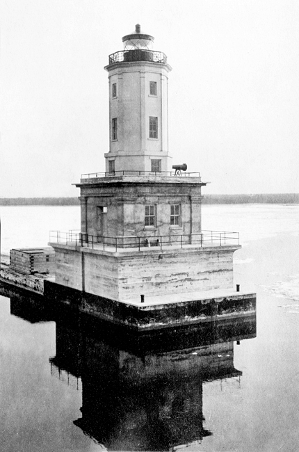

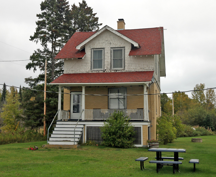
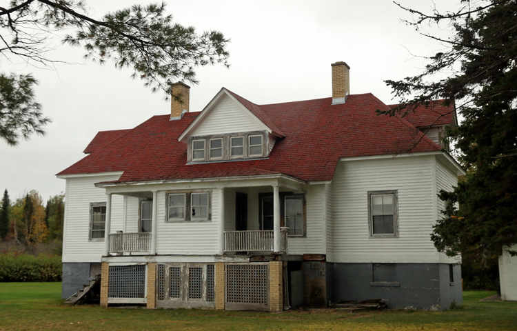
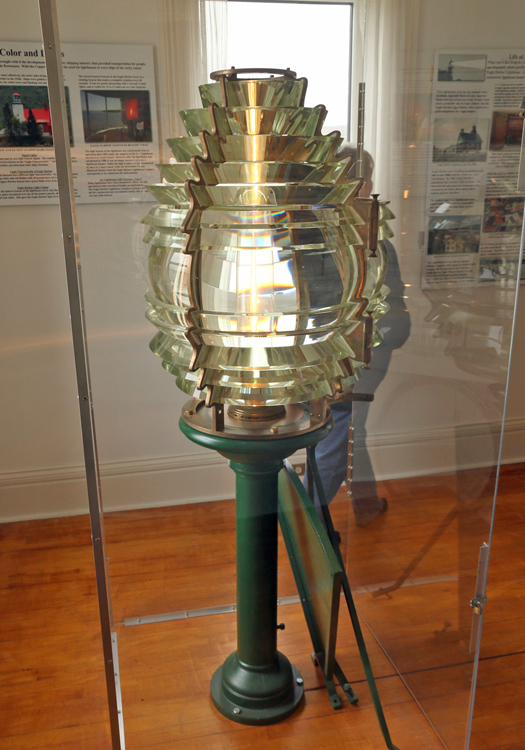
Photo Gallery
Photo Gallery
A committee dispatched to the Great Lakes in 1863 to report on the necessity of proposed lighthouses recommended several new lights be built on Lake Superior to support the burgeoning iron and copper trade. One of these lights was a small light at the end of the pier extending from the mouth of Portage River. The dredged entrance channel was not much wider than a steamer, and in order to enter it at night, a vessel had to first lower a small boat and send out a lantern to mark the entrance. The committee felt that the keeper of Portage River Lighthouse could mind the pier light, as it was only a fifteen-minute-walk away, and recommended that he be paid an additional $200 to do so.
|
At the opening of navigation in the spring of this year the value of the copper which had accumulated during the winter at Portage lake amounted to seven hundred thousand dollars. The whole yield of all the American copper mines in the region bordering on Lake Superior, during the preceding year, was estimated at ten thousand tons, which, at five hundred dollars per ton, would be equal to five millions of dollars.The precise significance of these figures will not, however, be perfectly understood, unless a single glance is taken at the population of these mineral regions. The most populous portion is that bordering on Portage lake and river, where stand the two towns of Houghton and Hancock; the former of which is a handsome as well as a flourishing village, and has a hotel that would do no discredit to any country town in the Atlantic States.
There is now in the two towns and in the adjacent mines a population of seven thousand people, and yet the first tree was cut in Houghton five, and in Hancock three years ago.
In 1866, Congress appropriated $1,500 on April 7 and another $6,000 on July 28 for the construction of range lights to mark the entrance to Portage River from Keweenaw Bay. Title to the proposed sites for the lights was obtained in May 1867, and the range lights were constructed during the 1868 season. The rear light was exhibited from a short tower atop a five-room keepers dwelling, while the front light shone from a wooden tower. The structures used for Portage Range were similar to those erected during the same time period at Eagle Harbor, Copper Harbor, Baileys Harbor, Grand Island, and Presque Isle. Earl Edgerton was hired as the first keeper responsible for Portage Entry Range Lights.
The range lights were situated in a low marsh on the west side of the river and connected by a plank walk that spanned the 728 between them. As the walkway was flooded during periods of high water or by the wash of passing steamboats, the Lighthouse Board requested $900 in 1870 to elevate the walkway and towers. In 1884, the crib around the front tower was raised one foot, and the keepers dwelling was raised two feet and a cellar placed under it.
After being damaged by lighting on July 26, 1899, the keepers dwelling was repaired and equipped with a lightning conductor. In 1900, a new wooden tower was built for the front light, and the following year, a brick oil house was erected near the keepers dwelling. The intensity of the rear light was increased in 1906 by substituting a fifth-order lens for the original sixth-order lens.
Work on a structure to mark the pier at Portage River began in June 1902, after the tender Amaranth delivered the necessary materials. A twenty-seven-foot-tall, two-story, frame tower was erected on the pierhead, and a 10,000-blow fog-bell apparatus was installed in its enclosed upper story. A small dynamo on shore, which was connected to the tower by 3,700-foot-long wires laid along the pier in grooved boxes, could be cranked by hand to start the bell tolling. The towers five-day lens lantern and fog bell were placed in operation in August 1902.
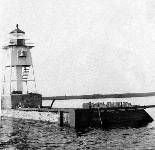
The new fog bell was declared inadequate as early as 1905, and pleas were made for a steam fog whistle and a second-order light to mark the river entrance. Mariners claimed that the noise of the waves and the ships machinery often made it impossible to hear the bell at a distance of more than 100 feet. As a stopgap, a new iron tower, fitted with a fourth-order fixed red light and a 1,500-pound fog bell, replaced the frame tower and its minor light on April 24, 1911.
The federal government purchased the twenty-five-mile-long Keweenaw Waterway on August 3, 1891, and then set about making improvements. In 1897, the Lighthouse Board published a Notice to Mariners describing a number of new lights along the waterway that were activated that August. In total, there were over twenty lights that marked the waterway.
On June 21, 1913 work began on a new harbor of refuge located just inside the mouth of Portage River consisting of a basin and a 2,000-foot-long mooring pier. As the improvements at Portage River were nearing completion, Congress provided $100,000 on June 12, 1917 for new navigation aids to mark the outer end of the breakwater and for electric lights along the Portage River portion of the waterway.
|
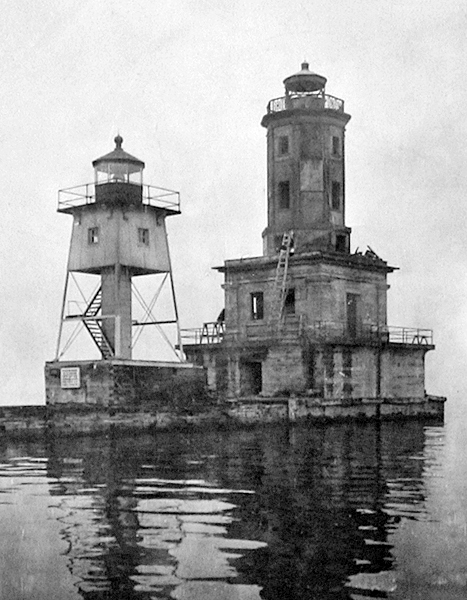
The former system of aids were [sic] inadequate, owing to extensive improvements of this important waterway by the United States Army Engineers. The new project included the construction of a light and fog signal station at the extremity of Portage Entry Breakwater, discontinuance of the old Portage River Lighthouse, rebuilding 11 and constructing 2 new minor light structures inside the harbor and along Portage River, also the construction of a power house and quarters for three keepers on shore and laying of electric transmission lines.The main light and fog signal structure, located at the extreme end of the breakwater, is an octagonal tower of structural steel, about 14 feet in diameter and 30 feet high, surmounting a reinforced concrete building 28 feet square and 16 feet high, which forms the first story. The foundation is a stone-filled heavy timber crib, 32 by 50 feet, resting on piles cut off at lake bottom level and extending to about water level and capped with a solid block of concrete 8 feet thick. One-half inch steel plates protect the sides of this block from ice damage. On top of this subbase a concrete pier 35 feet square and 11 feet high was constructed, with vaulted interior for storage space. The top of this pier is heavily reinforced to support the tower proper, on the top of which is a standard fourth-order helical bar lantern. The focal plane of the lantern is 68 feet above the lake level. The minor light structures are steel towers on concrete block foundations.
The power house is pressed brick, the foundation of concrete, and the roof covered with asbestos shingles. The basement contains a cooling tank for the compressed-air line, water pumping plant, coal-storage space, and a well for circulating water for the fog signal engines. On the main floor there is installed two air compressors, two electric generating units, four electric flashers, switchboard, and auxiliary apparatus.
The illuminating apparatus at the main light is a fourth-order fixed lens provided with a 200-watt incandescent lamp and a device for placing a spare lamp in operation in case of the failure of the lamp in service. Current is obtained through a cable from the power house. The light is occulting white, of approximately 6,500 candlepower. The illuminating apparatus for the minor lights consists of incandescent lamps in post lanterns, each provided with a lamp replacement mechanism for substituting a spare light in case of failure of lamp in use and also an annunciator system, which indicates at the power house the location of any such failure. Current for the minor lights is carried on a transmission line from the power house. Overhead, underground, and submarine conductors are used as local conditions require. The generators are 5-kilowatt capacity, direct connected to 10-horsepower oil engines.
The fog-signal outfit comprises a 6-inch automatic siren, electrically operated valve and storage tanks installed in the main light and fog-signal building, and duplicate oil engine-driven air compressors and sign flasher for controlling the siren valve installed in the power house, which is located at the shore end of the breakwater about 3,500 feet from the light station. Compressed air for the siren is delivered from the compressors to the siren through a 2 ½-inch pipe line. Special means are employed to thoroughly dry the air before it enters the pipe line to avoid trouble from freezing.
No difficulty of this kind has been experienced nor does there appear to be an undue loss of pressure in the line. This entire fog-signal installation has operated thus far with complete satisfaction.
For the proper operation of this system of aids the services of four keepers are required. The structure of the discontinued Portage Entry has been retained as quarters for one assistant keeper, a former dwelling has been remodeled to provide quarters for two keepers, and a new dwelling constructed. The new dwelling contains six rooms and basement. The lower story is brick and the upper story shingled. Heating plants and plumbing facilities have been provided for all three dwellings. Practically the entire work of construction was carried out by hired labor, utilizing the field equipment of the district, this having been considered the most practical and economical method.
|
Joseph St. Andre was one of twelve children that Keeper Oliver and his wife Eva raised at the lighthouses at Tawas Point, Marquette, and finally Keweenaw Waterway. Joseph joined the lighthouse service at age sixteen and served on a construction crew for twelve years, working at various lighthouses during the summer and repairing lighthouse tenders and lightships during the winter at Detroit. One Sunday, after the St. Andre family had rowed across Portage River and driven to church in Chassell, Joseph was reading the Sunday paper when he had a premonition that one of his younger siblings was in trouble.
Joseph raced out to the river and looked over the embankment to discover his brother Paul, ten years his junior, floating beneath the surface of the river. Still dressed in his suit and tie, Joseph ripped off his coat, kicked off his shoes, and jumped. After dragging Paul back to the embankment, Joseph called for help to lift his brother out of the water. Paul was all right after a little while, but the family never forgot the day when Joseph saved his brothers life, and not long after the incident, all the St. Andre children learned how to swim.
The fog signal at Keweenaw Waterway Lighthouse was changed from an air siren to an air diaphone in 1943.
In May 2014, Keweenaw Waterway Lower Entrance Lighthouse, deemed excess by the Coast Guard, was made available under the guidelines of the National Historic Lighthouse Preservation Act to eligible entities defined as Federal Agencies, state and local agencies, non-profit corporations, educational agencies, or community development organizations, for education, park, recreation, cultural, or historic preservation purposes. Interested parties were given six months to submit an application for ownership. Keweenaw Waterway Lighthouse Conservancy was formed in 2014 to protect lighthouses along Keweenaw Waterway, and the group was awarded the lighthouse on September 20, 2016. The conservancy received funds in 2018 from the Michigan Lighthouse Assistance Program to help complete a condition assessment report, but the organization seems to have gone inactive shortly after this.
In March 2022, the General Services Administration issued a call for letters of interest from entities willing to care for the lighthouse. After no new steward was found, an auction was initiated for Keweenaw Waterway Lower Entrance Lighthouse on August 1, 2023. Ten bidders participated in the auction, which closed on September 20, with a high bid of $88,000.
Keepers:
References
