Oak Island Range, NC 
Select a photograph to view a photo gallery
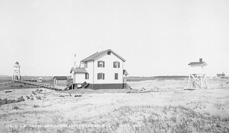
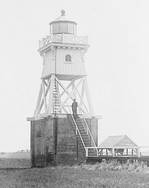

Photo Gallery


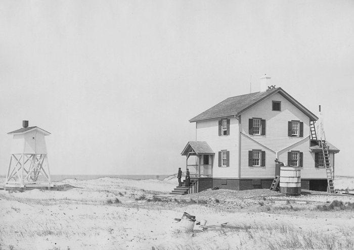
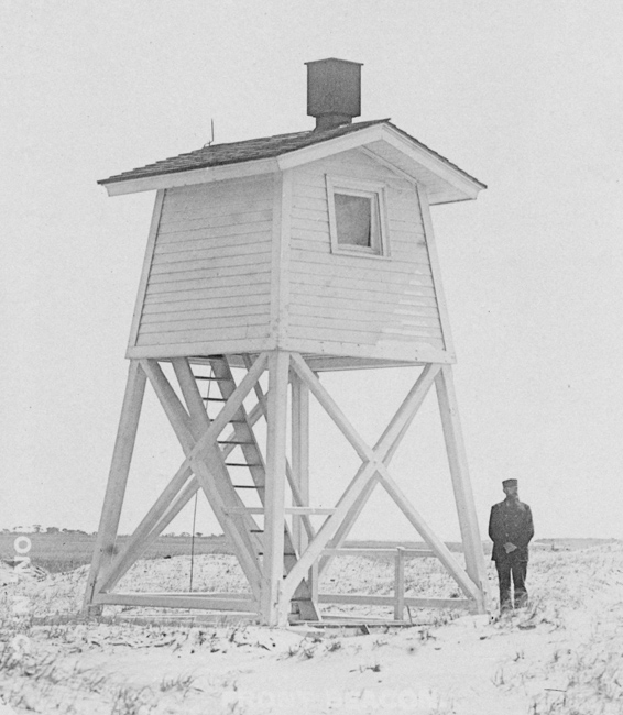
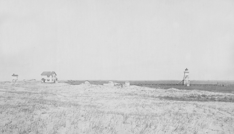
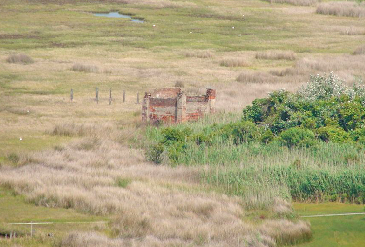
Photo Gallery
Photo Gallery
Along the shifting coast at the mouth of North Carolinas Cape Fear River, generations of mariners confronted one of the most hazardous entrances on the Atlantic seaboard. Sandbars migrated with storms and tides, channels opened and closed unexpectedly, and vessels bound for Wilmington or Brunswick navigated a watery maze that changed almost from season to season. To guide ships through these dangers, federal officials gradually constructed one of the Souths earliest integrated systems of navigational aids. Among the most important components of that effort stood the Oak Island Range Lightsmodest beacons whose purpose was not to warn mariners away from danger, but to lead them safely through it.
Though never as famous as the great tower on Bald Head Island, the Oak Island lights played a critical role for nearly half a century. Rebuilt repeatedly in response to erosion, shifting channels, and war, the station reflected the persistent struggle to adapt navigational technology to one of the most unstable maritime environments on the American coast.
The Cape Fear River occupied a unique position in North Carolina history. Unlike most rivers in the state, which emptied into protected sounds before reaching the ocean, the Cape Fear flowed directly into the Atlantic. This geography made it North Carolinas principal maritime artery and a natural outlet for the rich forests and agricultural lands of the coastal plain and piedmont.
From the colonial era onward, naval stores, lumber, rice, and agricultural goods moved downriver toward Atlantic markets. During the eighteenth century, the competing ports of Brunswick and Wilmington sought dominance over this lucrative trade. Brunswick, established nearer the mouth of the river in 1726, initially held an advantage by accommodating deeper-draft vessels below the shoals known as The Flats. Wilmington, founded farther inland in the 1730s, eventually prevailed because of its superior connections to the interior. By the eve of the Revolution, Wilmington had emerged as the regions principal commercial center.
|
Yet access to Wilmington remained difficult. Mariners approaching from sea first crossed dangerous offshore bars before selecting among several channels threading between shoals and tidal flats near the rivers mouth. Once inside, vessels still faced hazards at New Inlet, Horseshoe Shoal, Prices Creek, Campbells Island, Orton Point, and the Upper Jettee below Wilmington. Pilots familiar with local waters guided ships by day, but nighttime navigation remained perilous.
Recognizing the importance of Cape Fear commerce, Congress acted on August 14, 1848, by authorizing one of the most ambitious navigational improvement programs yet attempted in North Carolina. Rather than funding isolated aids, lawmakers envisioned an integrated system to guide mariners from the ocean to Wilmington step by step. The appropriation included funds for two range lights on Oak Island to mark the western entrance channel; paired beacon lights at Prices Creek; a beacon on Campbells Island; a beacon at Orton Point; a beacon on the Upper Jettee; and a floating lightship at Horseshoe Shoal between New Inlet and Prices Creek.
Uncertain about the rivers local conditions, Fifth Auditor Stephen Pleasonton requested a formal naval survey under the new lighthouse law. Commander William A. Gardner examined Cape Fear later in 1848 and concluded that every authorized light was necessary. Together, the stations would create a carefully coordinated chain guiding vessels inland through one of the Souths most difficult waterways.
Among the improvements approved in 1848, the Oak Island Range Lights occupied perhaps the most important position. Located near the mouth of the river, they would serve as the first inland guide after ships crossed the ocean bar. By aligning the two lights verticallyplacing one directly above the other in a mariners line of sightpilots could safely steer through the western or Oak Island channel.
Pleasonton envisioned the lights as modest but practical structures. Initial correspondence suggested towers of only twenty and thirty feet, visible roughly six miles at sea and built upon federal property already controlled near Fort Caswell on Oak Island. Though some smaller Cape Fear beacons might be constructed of wood, officials preferred brick for Oak Island because of the exposed coastal environment.
Late in 1848, Superintendent of Lights William C. Bettencourt received instructions to advertise for proposals to construct two brick towers and a keepers dwelling. The towers were to be identical except for height, one standing twenty feet and the other thirty feet tall. Each would be fitted with ten lamps and silvered reflectors manufactured by Winslow Lewis of Boston, whose lighting apparatus illuminated many American lighthouses during the period.
Only a single contractor, Bradford Sherman, submitted a proposal. Although Pleasonton complained of a lack of local competition, the bid$6,608remained within the appropriation once lighting equipment costs were included. Construction proceeded rapidly under the supervision of overseer John C. Wood.
By August 1849, the towers stood complete, built of brick laid largely in cement mortar and accompanied by a modest keepers residence. The two beacons entered service on September 10, 1849, for a total cost just under the congressional appropriation of $9,000.
The original Oak Island lights consisted of simple brick towers surrounded by shifting dunes near the river entrance. One stood approximately ten feet taller than the other, allowing navigators to align them and safely cross the Oak Island bar. Their lamps displayed fixed white lights from lantern rooms enclosed in heavy iron framing.
Jacob Brinkman, the stations first keeper, was paid an annual salary of $400. His dwellingdescribed as comfortable by inspectorscontained two principal rooms, a kitchen, and lodging space above. Yet maintaining the station proved difficult from the beginning. Water frequently flooded the low ground between structures, requiring officials to authorize construction of a raised causeway. Salt air, driving rain, and blowing sand rapidly deteriorated mortar, forcing repairs almost immediately after construction.
Despite official optimism, the station soon revealed significant shortcomings.
An 1851 inspection criticized nearly every aspect of operation. Though the towers themselves remained structurally sound, inspectors found the lamps poorly arranged, with several beams shining uselessly into surrounding woods rather than seaward. Lantern rooms blackened by soot had never been properly cleaned or painted, reflectors were scratched, and maintenance standards lagged badly.
The inspectors criticism extended to Brinkman himself. Illiterate and unfamiliar with proper lamp care, he relied upon others to complete official reports and lacked training in trimming lamps or maintaining equipment. During the inspection, officials reportedly gave instructions that noticeably improved the stations performance.
Structural concerns also persisted. Officials noted that the two towers stood too close togetherroughly 130 yards apartmaking the range difficult to distinguish from offshore. Furthermore, coastal erosion threatened the station almost from the beginning. Sand movement and surf continually altered the surrounding shoreline, leading one inspector to remark that wooden pile-supported towers might have performed better than brick structures fixed upon unstable ground.
Even so, the lights fulfilled an essential function. Working together with the Prices Creek range, Horseshoe Shoal Lightship, Campbells Island beacon, Orton Point Light, and later Federal Point Light, Oak Island formed the first segment of an increasingly coordinated route toward Wilmington. By 1855, a fog bell added another measure of protection for mariners approaching in poor visibility.
The Civil War brought abrupt disruption to the Cape Fear lighthouse system. Confederate authorities extinguished coastal lights to prevent Union naval forces from using them for navigation. As Union pressure intensified along the coast, retreating Confederate troops destroyed numerous aids rather than allow them to aid Federal operations.
The Oak Island Range Lights met this fate in 1861. Confederate forces reportedly demolished both brick towers, preferring to destroy them rather than leave them standing for Union use. The once-promising range disappeared, leaving only fragments amid the dunes.
Following the war, federal officials quickly recognized the continued importance of Cape Fear navigation. On July 4, 1866, a replacement range system commenced operation at Oak Island, though markedly different from its predecessors.
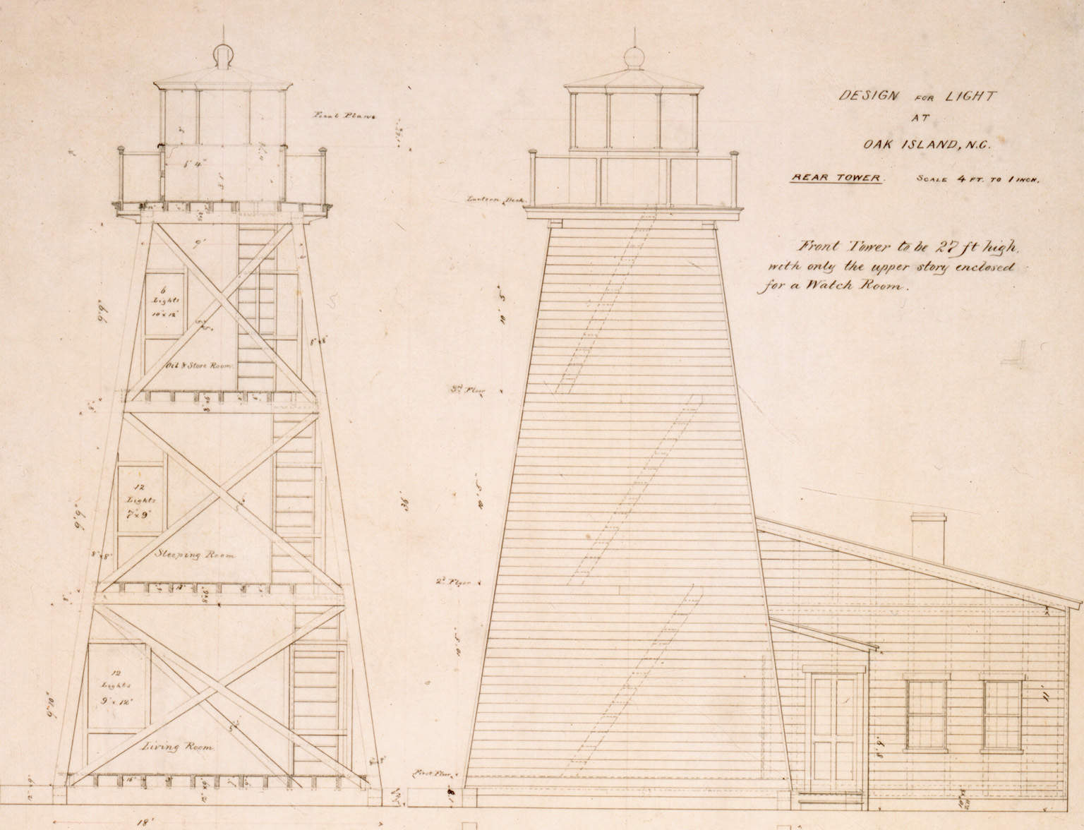
Rather than constructing new masonry towers, the Lighthouse Board adopted cheaper and more adaptable wooden structures. The rear range light occupied a lantern mounted atop a keepers dwelling, while the front light stood upon an open-frame skeleton tower positioned on a movable tramway. This unusual arrangement allowed the front beacon to shift laterally as channels changeda necessity in Cape Fears dynamic environment.
By the 1870s, however, officials again questioned the stations effectiveness. Reports repeatedly criticized the range for being too closely spaced, forcing navigators to deviate awkwardly before distinguishing the lights. Meanwhile, relentless erosion steadily consumed the shoreline surrounding the front beacon, placing it in imminent danger of destruction.
Congress appropriated $4,000 in 1874 to rebuild the station and secure a more effective alignment. Yet shifting channels delayed action repeatedly. Engineers debated whether Oak Island Channel itself might eventually become obsolete as dredging improved the Bald Head Channel. Only after several years of uncertainty did rebuilding proceed.
In 1879, new skeleton-frame beacons finally replaced the deteriorating postwar structures. Positioned slightly west of the earlier line and spaced roughly nine hundred feet apart, the rebuilt range substantially improved navigational precision. The front light rested upon a wooden tramway, allowing future movement if conditions changed again, while the rear beacon consisted of a skeleton-frame tower with an enclosed watch room, resting upon a brick foundation laid over a timber grillage.
Still, improvements continued. In 1881, officials raised the rear light by placing the tower atop a ten-foot-tall brick pier to improve visibility offshore, reducing the tendency of the lights to blend together. Repairs to dwellings, boathouses, oil houses, elevated plank walks, and tramways followed throughout the 1880s and early 1890s.
By then, however, the river itself had begun rendering decades of engineering obsolete.
The mouth of the Cape Fear remained in constant flux. Dredging projects, storms, and shifting shoals altered preferred navigation routes repeatedly. By 1885, the Oak Island range ceased marking the western bar channel and instead became part of a revised navigational system leading through the rivers main entrance toward Smiths Island and the re-established Bald Head Lighthouse and an accompanying beacon.
The front light moved 450 feet eastward in March 1885 to align with the new channel system. Mariners approaching from sea followed successive ranges in carefully timed sequence: first Bald Head, then Oak Island, then Smiths Island.
Yet nature again intervened. In October 1893, a storm destroyed the front beacon, forcing temporary measures while reconstruction proceeded. By the following year, continued channel changes rendered the range increasingly irrelevant.
In 1894, the Lighthouse Board ordered the station permanently discontinued. Officials concluded that altered channels at the river entrance had made the lights useless as navigational guides. Illuminating apparatus and valuable materials were removed and stored in Charleston for reuse elsewhere.
After nearly forty-five years of serviceinterrupted by war, rebuilding, and relocationthe Oak Island Range Lights disappeared.
Today, little remains of the original station. Remnants of the brick pier associated with the rear range light still survive on Oak Island, a modest archaeological reminder of the once-complex system that guided vessels through Cape Fears dangerous approaches. Nearby stands the modern Oak Island Lighthouse, completed in 1958, whose stark concrete form continues the islands long tradition of safeguarding mariners at the mouth of North Carolinas only river flowing directly into the Atlantic Ocean.