Port Sanilac, MI 

Select a photograph to view a photo gallery


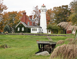
Photo Gallery
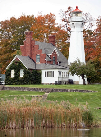
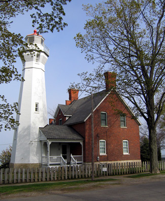

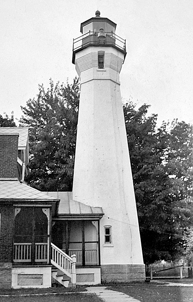

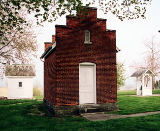
Photo Gallery
Photo Gallery
A harbor light was established at Harbor Beach, roughly fifteen miles south of Port aux Barques, in 1875. While this light reduced the dark space between Fort Gratiot and Point aux Barques, the Lighthouse Board maintained that an urgent necessity for a coastal light still existed.
|
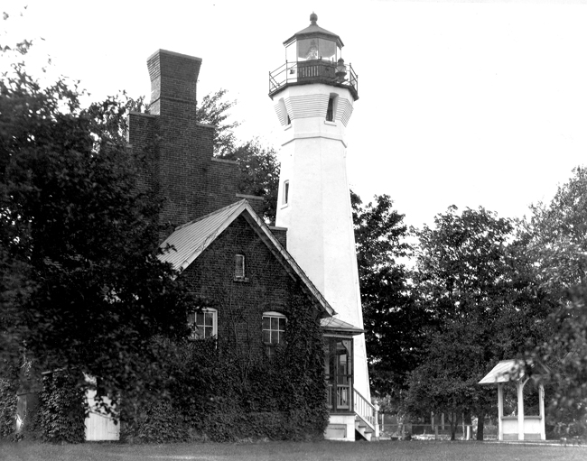
Situated 130 feet from the lakeshore, octagonal Port Sanilac Lighthouse stands fifty-nine feet tall and is connected to the nearby two-story keepers by a covered passageway. The eight-room dwelling had two, 2,200-gallon brick cisterns built beneath its kitchen that were used to collect rainwater for domestic use. Ile aux Galets Lighthouse is the only tower that resembles the one at Port Sanilac.
On July 15, 1889, a ruby chimney was placed atop the lamp inside the Fresnel lens to produce a fixed red light. The characteristic of the light was changed again on April 1, 1925 to a group of three, one-second white flashes, spaced by two seconds and followed by a five second-eclipse. The light was also electrified at this time, a change that increased its output to 18,000 candlepower.
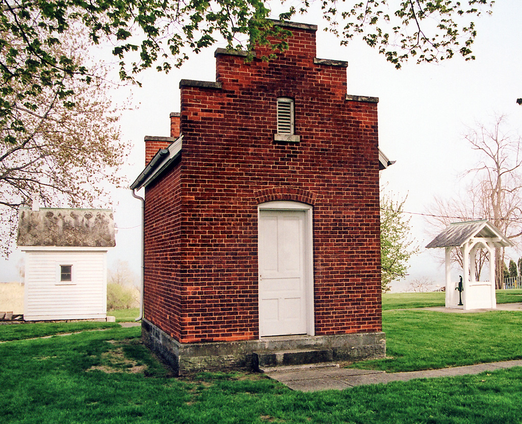
A new brick oil house, measuring eleven feet, ten inches by sixteen feet, four inches and capable of holding 360 gallons of kerosene, was added to the station in 1890. The stepped gables on the oil house complemented the one on the dwelling.
On October 13, 1886, Richard W. Morris, who was serving as first assistant keeper at Thunder Bay Island Lighthouse, was informed that he had been promoted to head keeper of Port Sanilac Lighthouse. Stormy weather prevented Keeper Morris and his family from leaving the island for Alpena until the sixteenth. At 1 a.m. on October 18, the Morris family boarded the steamer Flora at Alpena, and after becoming seasick in Saginaw Bay, safely arrived at Port Sanilac early on October 19. L. Lederle turned control of the station over to Keeper Morris later that day, and the light was exhibited for the first time the following evening. Keeper Morris served at Port Sanilac until 1893 and was later listed as working at the Eleventh Lighthouse District headquarters in Detroit.
William H. Holmes, who had replaced Keeper Morris as first assistant at Thunder Bay Island, succeeded Morris as head keeper at Port Sanilac. Holmes was serving at the lifesaving station on Thunder Bay Island when he met and married Grace Sinclair, the daughter of John Sinclair, the head keeper of Thunder Bay Island Lighthouse. The wedding took place on May 12, 1885, and the following year Holmes was appointed first assistant under his father-in-law. By the end of 1892, William and Grace Holmes had three children, and Keeper Morris reportedly resigned his position at Port Sanilac, so that Grace, who was his niece, wouldnt have to live apart from her husband in order for her children to attend school.
Keeper Holmes starting suffering from neuritis around 1920, and there were many nights when Grace had to haul the oil up the lighthouse stairs. Fortunately, she was well accustomed to lighthouse life by this point, being the daughter and granddaughter of lighthouse keepers. Keeper Holmes passed away of apoplexy on October 13, 1926, at the age of sixty-four, and Grace was appointed keeper in his place. As the light had been electrified in 1924, the keepers workload was much easier. Grace served as keeper until the light was automated in 1928, but she continued to keep a watchful eye on the light, as her new residence was located next door.
Carl Rosenfeld, of Carls Chop House fame, purchased the dwelling portion of Port Sanilac Lighthouse for $4,000 in 1928, four years before opening his popular Detroit restaurant. The tower, which still contains its Fresnel lens, was sold to the Rosenfeld family in 2000, though the Coast Guard is still responsible for the light. The light station was added to the National Register of Historic Places in 1984.
In 2012, the Rosenfeld family placed Port Sanilac Lighthouse, along with a three-bedroom guest cottage, on the market for $1.599 million. The keepers dwelling, which was thoroughly renovated in the mid-1990s, now features three nautical-themed bedrooms, one full bathroom, a half bath, a kitchen, living room, dining room, and a Florida room added in the 1940s with a wall of windows facing the lake. The historic brick oil house, wooden outhouse, and well also remain on the property. The lighthouse, without the guest house, was still on the market in 2013 with a sale price of $999,800.
Jeff Shook, founder of Michigan Lighthouse Conservancy and owner of St. Clair Flats Canal Range Light Station, purchased Port Sanilac Lighthouse for his family in 2014 for $855,000. While he plans to use the property as a vacation home, Shook is investigating the idea of opening the lighthouse to the public on a limited basis. Shooks great-great-great-great-great grandparents were the first lighthouse keepers at Point Aux Barques Lighthouse, just up the coast from Port Sanilac.
On September 13, 2016, the historic Fresnel lens was removed from the tower, and the Coast Guard installed a multi-tier LED beacon in its place. The characteristic of the light was changed from a group of three white flashes every ten seconds to a white flash every two-and-a-half seconds. After being restored, the Fresnel lens was placed in a plexiglass case and situated near a window at the base of the tower where visitors can see the lens when they climb the lighthouse.
Starting on Friday July 7, 2017 and continuing on every Friday in July and August of that year, the public was allowed to visit the lighthouse between 11 a.m. and 2 p.m. Sanilac County Historical Society conducted the tours.
Head Keepers: Richard W. Morris (1886 1893), William H. Holmes (1893 1926), Grace Holmes (1926 1928).
References

