Île Ste-Thérèse Upper Range, PQ 
Select a photograph to view a photo gallery


Photo Gallery
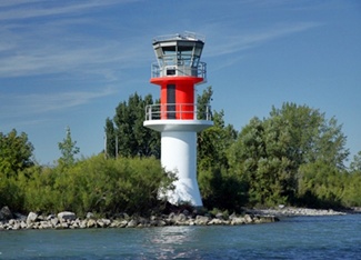
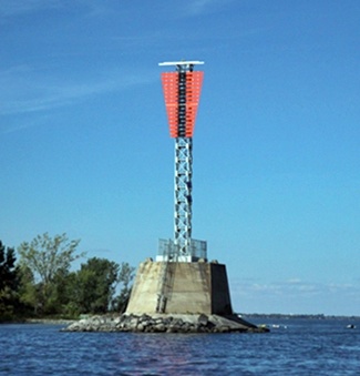


Photo Gallery
Photo Gallery
|
In 1871, a shoal that obstructed the channel at Pointe aux Trembles was removed, necessitating a range to light the new channel that was established as a result. The Department of Marine found that an additional light placed in one of the existing towers on Île Sainte-Thérèse could function with a new lighthouse, erected at a cost of $252, to form a new range. Theo. Brodeur was in charge of the three lights exhibited from the older two towers, while Samuel Reeves was placed in charge of the new light established in 1871. Each light was produced by a No.1 flat-wick lamp, set in a fifteen-inch reflector.
The government purchased parcels of about twenty-four square feet for each of the original towers from Mr. Massue and Mr. Bradeur. For the 1871 light, the government occupied a twenty-four-square-foot piece of land, which belonged to the heirs Rivet but could not be sold on account of the absence of some of the family.
A $760 contract for two new lighthouses for Île Sainte-Thérèse was awarded to Mr. J. Sheridan of Montreal in 1879. These towers were erected on the southern end of the island to lead vessels through the new channel at Point aux Trembles and were placed in charge of Samuel Reeves, the keeper of the 1871 lights, which were discontinued. Known as the Île Sainte-Thérèse Upper Range Lights as they were located on the upstream end of the island, these lights were modified after a contract was awarded to John Black of Hull in 1883 for the construction of two new piers for the lights.
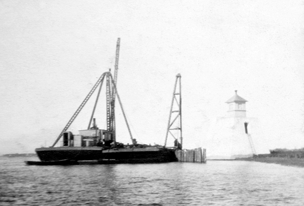
In 1884, John Black moved the back tower of this upper range 700 feet to a pier, where its light was shown at a height of fifty-four feet above the river. At the same time, the upper range front light was moved farther upstream to a low islet known as Isle aux Vaches, where it was 5,000 feet from its companion back light. A new hexagonal, wooden tower was built atop a timber work pier for the front light, which had a focal plane of twenty-nine feet above the river.
During the spring of 1885, ice caused considerable damage to the new pier built for the back light of the upper range, and its tower was swept a great distance downstream. Mr. F. T. Thomas of Ottawa was contracted to make the necessary repairs and restore the tower to its pier at a cost of $950.
|
In the spring of 1896, ice caused considerable damage to the pier at Île Sainte-Thérèse Lower Back Light. Iron plates and facing were torn off, requiring two sides and a good portion of the pier to be replanked.
In 1905, the Department of Marine published the following description of new lights that were established on Île Sainte-Thérèse Upper Range:
Two new range light buildings were erected on the north side of the ship channel of the River St. Lawrence, off the upper end of Ile Ste. Therese, to mark the axis of the widened Pointe aux Trembles channel from Ile aux Vaches traverse to Longue Pointe curve.These two new buildings replace the old front range light on Ile aux Vaches, and the old back range light on the south shore of Ile Ste. Therese, which marked this course.
The new range lights were put in operation on November 15, 1904, and the old ones discontinued on the same date, and taken down.
The new front building stands on the south shore of Ile aux Vaches, 75 feet C. 53° 30 E. from the old one. The foundation consists of a concrete pier 18 feet high, built with a pointed nose upstream, surmounted by an octagonal wooden lantern, painted white, and 17 feet high from its base to the ventilator on the lantern.
The light is fixed white catoptric, elevated 32 feet above the summer level of the river, and visible 4 miles in the line of range.
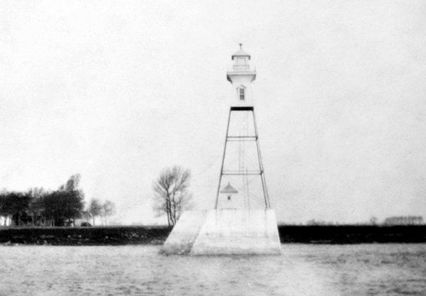
The back tower stands off the south shore of Ile Ste. Therese, 75 feet S. 53° 30 E., from the site of the old tower, and 5,030 feet N. 36° 80' E. from the front light. It is a square building with sloping sides, consisting of an open steel framework with wooden slats on the upper portion of the side facing the alignment, surmounted by an inclosed wooden watchroom and a square wooden lantern. The steel frame is painted red and the woodwork, including the slats, white.
The building is 71 feet high from the pier to the ventilator on the lantern, and stands upon a concrete pier rising 20 feet above the summer level of the river.
The light, which is similar to that shown from the front tower, is elevated 84 feet above the water.
The buildings were erected by days labour under the superintendence of Mr. Ernest Roy, at a cost of $8,085.21.
The back steel tower was supplied by The Goold, Shapley & Muir Co., of Brantford, Ont., and cost $610.
In 1924, a new wooden front tower was built for the lower range to replace the old one that was unfit for further service. This photograph is of the companion rear range tower in 1933.
Today, a square skeleton tower mounted atop a concrete pier serves as the back light of the Île Sainte-Thérèse Upper Range, while a white cylindrical tower topped by an octagonal lantern serves as the front light. The Île Sainte-Thérèse Lower Range also remains active, exhibiting fixed green lights from cylindrical towers.
Head Keepers:
References