Stokes Bay Range Rear, ON 

Select a photograph to view a photo gallery

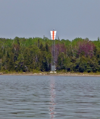

Photo Gallery
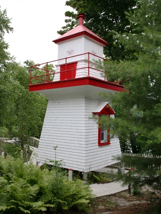

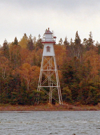
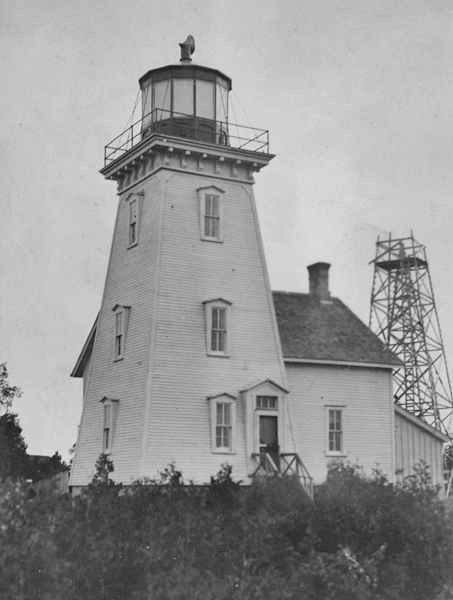
Photo Gallery
Photo Gallery
In 1904, a pair of range lights was erected in Stokes Bay to help guide vessels between Lyal Island and Mad Reef, replacing a pair of day beacons that had previously served this function. The front range light was placed on the northwestern end of the largest of the Knife islands, while the rear range light was located on the mainland east of the front light. The following description of the new range appeared in the Annual Report of the Department of Marine for 1904:
Range light buildings have been erected as indicated in last years report at Stokes bay on the east shore of Lake Huron, and the lights were put in operation on or about the 25th August, 1904.The front tower stands upon the northwest extreme of the most westerly of the Knife islands, a group of small islands lying 1/2 mile north of the northeast point of Lyal Island, and stands upon the site of the front one of a pair of day beacons which have been taken down.
The tower is a wooden structure, square in plan, with sloping sides, surmounted by a square, wooden lantern, the whole painted white. It is 33 feet high from its base to the top of the ventilator on the lantern.
The light is a fixed white light, elevated 30 feet above the level of the lake, and should be visible 10 miles in the line of range. The illuminating apparatus is catoptric.
The back tower stands upon the mainland on the east shore of the bay, on the site formerly occupied by the back beacon. It is distant 4,250 feet, N. 74° E. from the front tower.
The tower consists of a skeleton steel frame, square in plan, with sloping sides, surmounted by an inclosed wooden watch room and a square, wooden lantern. The steel frame is painted brown and the woodwork white. The tower is 64 feet high from its base to the ventilator on the lantern.
The light is a fixed white light, elevated 61 feet above the level of the lake, and should be visible 13 miles in the line of range. The illuminating apparatus is catoptric.
These buildings were erected by days labour, under the superintendence of Mr. W. K. Morris, of Ottawa, and cost $2,641.12.
D.L. McLay served as first keeper of the range lights until he died of heart failure in 1908 and was replaced by Alexander Smith. Norman McDonald, who served in the first battalion of the Canadian Expeditionary Force in World War I and lost his left leg in the battle at Amiens on August 30, 1918, was the longest-tenured keeper of the range lights, caring for them from 1920 to 1956.
In the 1990s, the wooden square pyramidal tower that had served as the front range light was replaced by a cylindrical tower. Fortunately, the old tower was not torn down, but the abandoned structure faces an uncertain future. The Bruce Peninsula Lightkeepers Association has been formed to save the front range lighthouse. The group is raising funds to restore the tower and in October 2012 submitted a grant application to the Ontario Trillium Fund.
In late summer 2009, the Canadian Coast Guard informed Bruce County of its intention to replace Stokes Bay Rear Range Lighthouse, which consists of a three-tiered, tapered steel frame, surmounted by a wooden watchroom and lantern. Not willing to lose part of its marine heritage, the county quickly devised a plan wherein a heavy-lift helicopter, owned by National Helicopters in Vaughn, Ontario, would transport the lighthouse in two pieces to the parking lot of Black Creek Provincial Park where it would be loaded on a heavy equipment float and trucked to Southampton. A YouTube video of the removal of the lighthouse, which took place in December 2009, is available. After volunteers reassembled and restored the lighthouse using traditional paint and craftsmanship, a celebration was held at the Bruce County Museum and Cultural Centre in June of 2011 to celebrate the opening of its new Stokes Bay Lighthouse exhibit. The upper portion of the lighthouse stands in the museums backyard overlooking Fairy Lake.
Head Keepers: D.L. McLay (1904 1908), Alexander Smith (1908 1913), John McIver (1913 1919), R. McIver (1920), S.J. Hayes (1920), Norman McDonald (1920 - 1956).
References