Port Saint-François Range, PQ 
Select a photograph to view a photo gallery
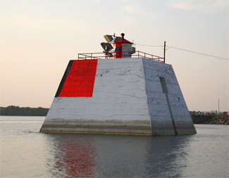


Photo Gallery

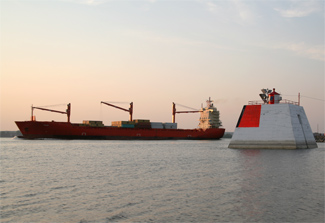

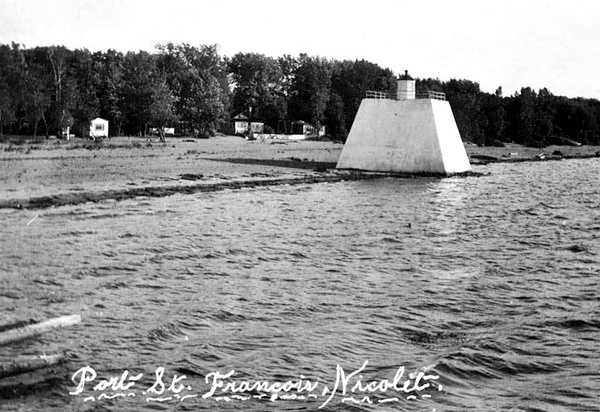
Photo Gallery
Photo Gallery
|
The wooden tower, from which the rear range light was displayed, was destroyed in a storm in September 1901, forcing Francois Manseau, the keeper at the time, to display a temporary rear light in the form of a lantern hoisted on a mast. A thirty-one-foot-tall, steel, skeletal tower replaced the temporary light on June 21, 1902. This square, pyramidal tower was surmounted by a square, galvanized-iron lantern and had served on Île aux Prunes near Verchères until the lights in that area were rearranged. To make the brown tower more conspicuous, a target of wooden slats, painted white, was attached to the upper half of its upstream face.
In 1906, a pair of new ranges lights was erected at Port St. Francis as described by the following excerpt from the Annual Report of the Department of Marine:
Two permanent concrete piers were constructed and range lights erected upon them. Each of the piers is 42 feet square at base, 25 feet square at top, and 28 feet high. The front pier is surmounted by an octagonal iron lantern, painted red, showing a fixed white catoptric light. The back light is exhibited from an open steel framework tower, square in plan, with sloping sides, surmounted by an inclosed wooden watch-room and octagonal iron lantern. The height of the tower, from its base to apex of lantern is 64 feet. The tower was supplied by Messrs. Goold, Shapley & Muir, of Brantford, Ont., and cost $502.80, and the cost of building the piers and erecting the steel tower and front light, which was done by days labour, under the supervision of the Montreal agency, was $31,732.97.
No longer needed, the skeletal tower erected at Port St. Francis in 1902 was relocated to Île a la Bague. The two concrete piers are situated 792 feet apart, one on each side of the wharf at Port St. Francis, but at some point between 1955 and 1994, the rear range light was moved from the pier east of the wharf to a tower atop a new pier located 4,500 feet from the front light. The characteristic of the range lights was also changed during this period from fixed white to fixed green. With the rear light in its new location, the range lights are now aligned along a bearing of 68° instead of 64°.
Keepers: Jean Chaurette (1861 1875), Ernest Duval (1875 1890), E. OShaugnessy (1890 - 1896), Philippe Brassard (1896 1899), Francois Manseau (1900 1912), F. Proulx (1912 1922), A. Cecile (1922), J.B.R. Manseau (1922 1931), E. Duval (1931 1936), J.B.R. Manseau (1936 at least 1937).
References
