Île Richelieu, PQ 
Select a photograph to view a photo gallery
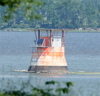
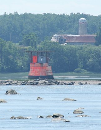
Photo Gallery


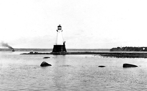
Photo Gallery
Photo Gallery
|
Leaving Three Rivers, there is scarce any variation in the general aspect of the St. Lawrence until arriving at the Richelieu rapid (about fifty-two miles), where its bed is so much contracted or obstructed by huge masses of rock, as to leave but a very narrow channel, wherein at ebb tide there is so great a descent, that much caution and a proper time of the ebb is necessary to pass through it; at the end of the rapid is a good anchorage, where vessels can wait their convenient opportunity. From Montreal, thus far, the banks are of a very moderate elevation, and uniformly level, but hereabout they are much higher, and gradually increase in their approach to Quebec, until they attain the altitude of Cape Diamond, upon which the city is built.
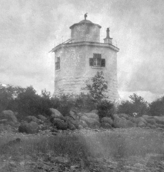
Among the first lights to be established along the St. Lawrence River between Montreal and Quebec were one established on LIslet Richelieu (Île Richelieu) in 1816 and one on nearby Point Platon that same year. Île Richelieu Lighthouse was described in an 1861 light list as a square, wooden tower having a height of twenty feet. This structure employed two No.1 flat-wick lamps and fifteen-inch reflectors to produce a fixed white light at a height of twenty-seven feet above the river.
Some of the early keepers of the light were women including Helene Blais, Catherine Blais, and Julie Blais, who took care of the light, one after the other, from 1861 until 1890.
Owing to a complaint by the captains of the Richelieu Company, William Barbour, the district engineer for the Department of Marine in Quebec, was dispatched in 1874 to ascertain the cause of the alleged feeble light exhibited at Île Richelieu. Barbour found the light to be well kept by Keeper Helene Blais, but the smallness of the lantern room made it impossible to display a stronger light. A larger lantern room was subsequently installed, and a detached oil shed was built alongside the lighthouse, as Keeper Blais complained that keeping oil in the lighthouse spoiled her provisions. At this time, the lighthouse was described as an octagonal, stone structure that doubled as a lighthouse and dwelling.
Ice floes caused considerable damage to LIslet Richelieu Lighthouse in the spring of 1896, carrying away the oil shed, the door steps to the lighthouse, and a small platform. The Department of Marine noted that since Barre a Boulard was being dredged to equal the depth of the shipping channel and that this new channel would necessitate the removal of LIslet Richelieu Lighthouse, only a temporary shed would be erected at the lighthouse.
|
Île Richelieu Lighthouse and Planton Range were discontinued in 1916, leaving Barre a Boulard Range to mark the channel downstream from Richelieu Rapids. In 1968, the rear light of Barre a Boulard Range was made the ranges front light and a new tower was erected 3,425 feet northeast of the repurposed rear tower to house the rear light. The old front light on Richelieu Island Reef remained active and was afterward referred to as Rapides Richelieu Lighthouse or Île Richelieu Lighthouse.
The wooden octagonal tower that originally housed the front light of Barre a Boulard Range before becoming Île Richelieu Lighthouse was reportedly torn down in 1971. Today, two lights are shown from a white and fluorescent orange box mounted atop the circular stone base built for the Barre a Boulard front range light: a fixed yellow light visible on a bearing of 54° and a fixed green light between 160° and 250°. The green light appears to mark Île Richelieu and the rocky reef that extends north of it.
Keepers: Helene Blais (1861 1878), Catherine Blais (1878 1887), Julie Blais (1887 1890), Madam Gagnon (1890 1895), Celestin Page (1895 1899), Edouard Noel (1899 1902), Celestin Page (1902 1904), Simeon Page (1904), Joseph Auger (1905 1917).
References