Ash Island Range, PQ 
Select a photograph to view a photo gallery


Photo Gallery
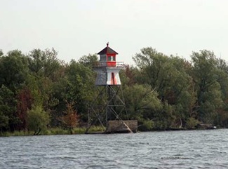
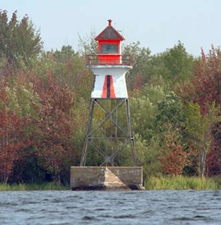
Photo Gallery
Photo Gallery
In 1871, the Department of Marine received a memorial from the Board of Trade of Saint-Jean requesting that several lights and buoys be established along the Richelieu River for the purpose of aiding and assisting the great, inland traffic that was carried along that waterway. Most of this traffic was lumber from Ottawa. After consulting with Trinity House of Montreal, Peter Mitchell, the Minister of Marine and Fisheries requested $5,000 from Parliament for the construction of eight lights to replace temporary lights that had been maintained on the river at the expense of private individuals.
During the spring of 1873, James Sheridan erected the following lighthouses on the Richelieu River for a contract price of $3,785: two at Half-way Point, two at St. Valentine, and two at Lacolle. In addition to these six lighthouses, temporary lights were maintained at Bloody Island and Ash Island during the 1873 season. The temporary lights at Ash Island and Bloody Island consisted of lanterns set atop a tripod and were kept by Ira Hammond at the rate of $20 per month until permanent structures were built in 1875.
The following description of the new lighthouses appeared in the Annual Report of the Department of Marine for 1875:
Two new light-houses were erected during the past season on the Richelieu River, one on Ash Island and one on Bloody Island, at a distance of three quarters of a mile apart. These lights are placed in range with the channel above the Islands, and the side-lights are to show the channel past the west side of both Islands. The light-house on Ash Island is a square framed tower with a small dwelling attached and painted white. The lights in it are about 44 feet above high water, and the main light shows in the direction of the low light on Bloody Island. The light-house on Bloody Island consists of a small white building on a timber pier about 14 feet above water, the main light showing up stream in the direction of the channel.Ash Island is situated just over five kilometres north of the Canada-U.S. border, and Bloody Island is located just upstream from Ash Island, closer to the border. Each of the lighthouses was equipped with two flat-wick lamps and two reflectors to produce their two lights.The lights shown are fixed white, on the catoptric principle. Both lights are in charge of Mr. Ira W. Hammond, who has had charge of temporary lights on these Islands for some years past. The total cost of these light-houses amounted to $2,825.
In 1884, a breakwater was built to protect the lighthouse on Ash Island and a new crib was constructed for the lighthouse on Bloody Island to replace one destroyed by ice.
Keeper Hammond was dismissed in 1887, and Joseph Shand was placed in charge of the lights instead at an annual salary of $200.
Ash Island is also known Île aux Têtes, French for Island of Heads. In 1694, an Abenaki war party encountered a band of Mohawk warriors near the island, and a battle ensued in which the Abenaki were victorious. To discourage additional Mohawk incursions into their territory, the Abenaki decapitated the Mohawk warriors and mounted their heads on stakes placed around the perimeter of the island. The Abenaki named the island Odepsék, meaning place of the heads.
The present Ash Island Front Range Lighthouse, a skeleton tower, square in plan, having sloping sides and topped with an enclosed watchroom and lantern room, was placed in operation in 1913. This new light had a focal plane of forty-four feet. The taller companion rear range tower remains standing on the northern shore of Ash Island. The range lights were deactivated in 2005. The Canadian Coast Guard no longer maintains any lighted navigational aids on the Richelieu River.
Head Keepers: Ira W. Hammond (1872 1887), Joseph Shand (1887 1894), George L. Robinson (1894 1901), E.M. Provonsil (1901 1903), James A. McGee (1903 1913), G.L. Robinson (1913 1916), E.S. Draffin (1916 1922), J. McGee (1922 at least 1937).
References