Dixon Point (Dixon Point Range Front), NB 

Select a photograph to view a photo gallery
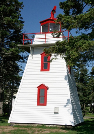

Photo Gallery

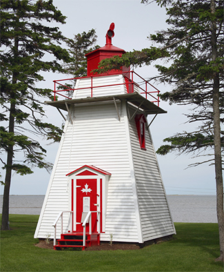
Photo Gallery
Photo Gallery
The construction of a pair of range lights to guide vessels into Bouctouche Harbour was noted in the annual report of the Department of Marine and Fisheries for 1881:
A contract was entered into with Mr. John Ward, builder, Shediac, for the construction of two wooden range light towers at Buctouche, and was satisfactorily executed by him, the contract price being $730. These lights stand on Dixons Point, on the south side of Buctouche Harbour, and guide vessels into the Harbour. The front building is situated on the point near the old beacon, and consists of a square wooden tower 30 feet high. The light is fixed, white, catoptric, elevated 36 feet above high water mark, and should be visible 11 miles in the direction of the range.Dixon Point Range Lights, put into operation on June 9, 1881, replaced a set of day beacons that had previously stood on Dixon Point. Thaddee B. Robichaud was hired as the first keeper of the lights at an annual salary of $150. The height of the rear range tower, from base to vane, was thirty-four feet.The back range light is distant 1,050 feet northwest by north from the other, the building is similar and a light of the same description is shown, elevated 41 feet above high water, and visible 12 miles.
Mariners would use the Dixon Point Range Lights to reach the entrance to Buctouche Harbour and then would follow the Church or Indian Point Range Lights, established in 1883, to enter the harbour up to the point where the channel turned abruptly westward to enter Bouctouche River.
Henry B. Robichaud served as keeper of the range for fifty-three years, and when died in 1936, his son Zepherin cared for the lights for a few months before Neri Maillet, the stations last keeper, was appointed.
The rear range tower was in very poor condition when Andre & Yvette Maille purchased it in 2005 for $1. The inactive tower has since been restored and relocated to the shore, just north of the still-active front tower. This work took place during 2009/2010. In 2008, the front tower was repainted, and the surrounding area received an environmental cleanup.
The population of Bouctouche has never been great, but it has produced one very notable billionaire, Kenneth Colin (K.C.) Irving, whose companies included Irving Oil and J.D. Irving Limited, which started as a sawmill in Bouctouche.
Keepers: Thaddee B. Robichaud (1881 1884), Henry Belonie Robichaud (1884 1936), Zepherin Robichaud (1936), Neri Maillet (1936 1962).
References