Destruction Island, WA 
Select a photograph to view a photo gallery

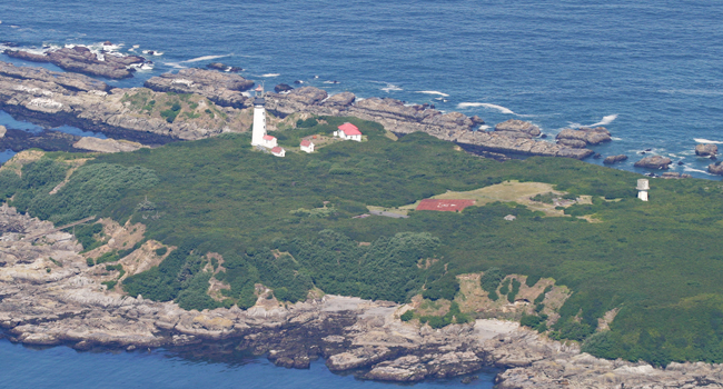
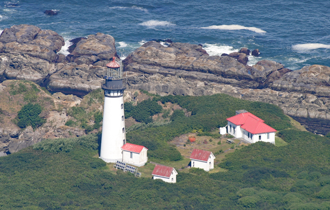
Photo Gallery
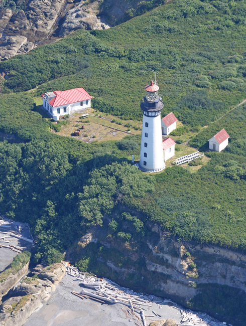


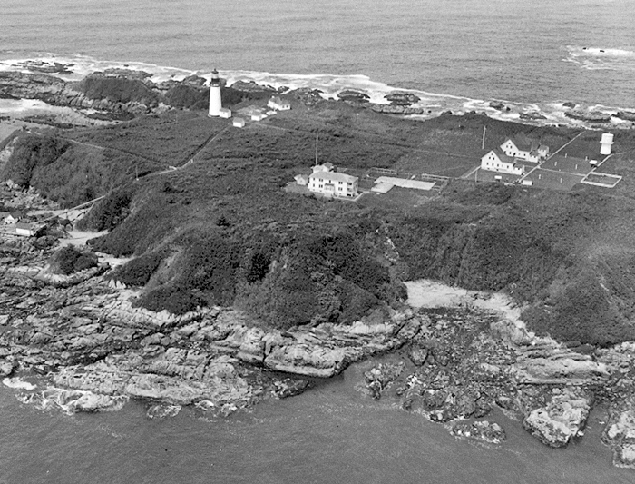

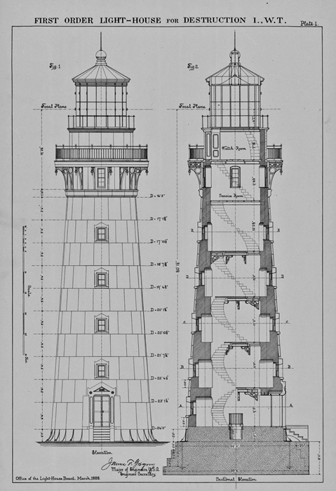
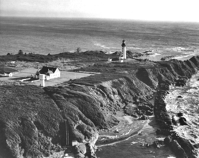

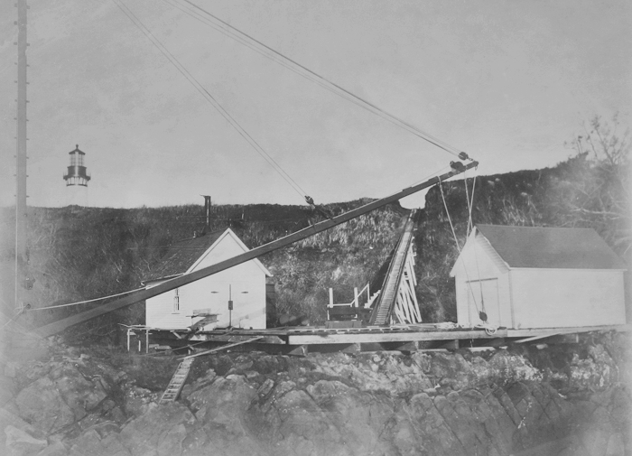

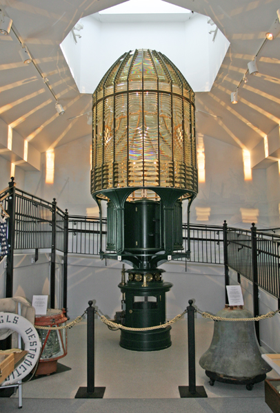

Photo Gallery
Photo Gallery
|
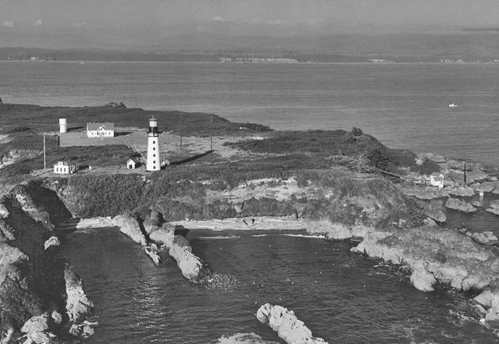
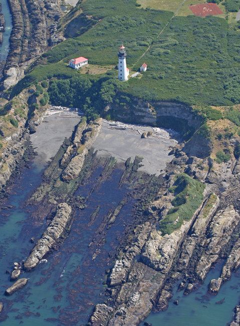
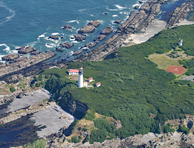
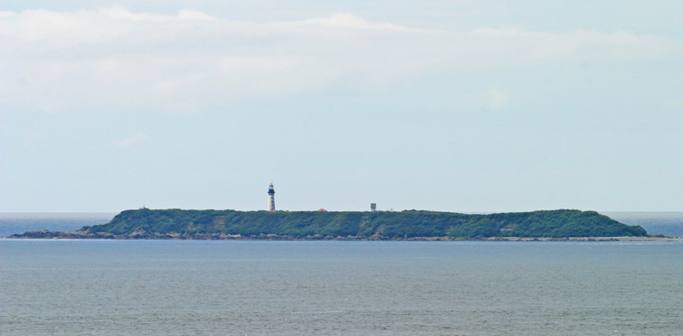
The thirty-three-acre, tabletop island rises roughly eighty feet above the surrounding water and is bordered by steep bluffs. An executive order issued by the Andrew Johnson administration in 1866 reserved Destruction Island for government purposes.
In 1884, the Lighthouse Board requested $85,000 for establishing a first-order light and fog signal on Destruction Island, but Congress granted just $40,000 for the purpose on March 3, 1885. As a light of any less order would not provide the aid navigators required, work on the project was delayed until Congress appropriated an additional $45,000 on August 4, 1886.
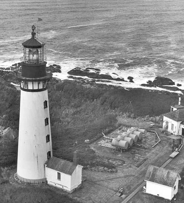
Bids for constructing the dwellings, fog signal building, barn, tramway, cisterns, and oil houses, for erecting the tower, and for furnishing the required metalwork were opened on May 29, 1888, and three separate contracts were awarded. James E. Smith was hired to erect the lighthouse for $11,800, while John Cooper of Mt. Vernon, Ohio was contracted to provide the metalwork for $22,400 and J. & S. Carkeek of Seattle were paid $29,595 to build the keepers dwellings and various outbuildings.
J. & S. Carkeek commenced work in August 1888 but had great difficulty in procuring transportation to the island for the construction materials. The need for a fog signal and light on Destruction Island was punctuated that same month when the sailing bark Cassandra Adams, one of the fastest clippers ever built in the Northwest, ran aground on the islands north reef. The vessel was traveling in a dense fog and struck the reef before the island was sighted. Heavy seas soon battered the ship to pieces, but the sixteen people on board made it safely to the island and then on to the mainland in open boats.
With the two, six-room keepers dwellings and other work complete, J. & S. Carkeek left the island on August 31, 1889, but it was later discovered that the cisterns didnt hold water, the cellar floor in the assistants dwelling was poorly laid, and much of the paint washed off the buildings with the first rain. The contractor was notified of the deficiencies, but when they failed to correct them, the retained percentage of his contract was used to complete the work by hired labor. The first principal keeper, Christian Zauner, arrived on the island 1889 with Thomas Campbell, an assistant, but there was little work for them until the station was completed. Prior to his appointment to Destruction Island, Keeper Zauner had spent three years as an assistant keeper at Tillamook Rock Lighthouse.
|
Four keepers were typically assigned to the station, with two living in each of the six-room dwellings, where were spaced fifty feet apart and located 550 feet east of the lighthouse. During the summer of 1896, six rooms were added to the north side of the assistant keepers dwelling, and, after this time, it was used to house the three assistants while the principal keeper enjoyed his own residence. The small community held its own school for the younger children, and raised chickens, cows, and vegetables to supplement the lighthouse rations delivered to the island.
A small workroom was added to the lighthouse in 1894 to aid the ventilation and drying of the interior of the tower. The keeper declared the work successful as conditions inside the tower greatly improved.
The stations fog signal was in operation around 500 hours each year, while consuming around 30 tons of coal. During the twelve-month period from July 1, 1895 to June 30, 1896, the fog signal sounded an incredible 1,855 hours, or over seventy-seven days. To facilitate the delivery of coal and other supplies, a tramway was installed that ran from the landing on the south side of the island, up the bluff, and then over to the fog signal building, with another branch leading to the dwellings. The need for coal was reduced in 1913, when the fog signal was converted from steam power to oil engines.
John F. Enquist arrived on Destruction Island in 1902, and by 1906 he had worked his way up to head keeper. After having been in charge of the station for five years, Enquist was returning to the island on August 7, 1911 aboard the lighthouse tender Heather when he was killed. Forty-four-year-old Enquist had been on leave in Seattle and was being transported from the Heather to the island in a small boat, when a derrick collapsed and a supporting wire struck him in the head. The stations logbook contains the following information for that day:
Light variable wind. Fine sunshine. Employed clearing the harbor out of seaweed. 11:20 USS Heather arrived from North with coal and Head Keeper, and as we was hoisting the coal at 1pm great calamity happened. The hoisting derrick fell down and Head Keeper John F. Enquist got killed. One of the supporting wires striked and split his head open. 2pm Heather departed with John F. Enquist and Mrs. Lien on board.
As the mainland shore near Destruction Island was sparsely populated and devoid of any natural harbors, the keepers at the station played a critical role in helping any vessels in distress. On November 30, 1914, the four-masted Schooner Aloha anchored off the south side of the island, and a Captain Petterson and one sailor rowed ashore to seek assistance. The vessel, which had left Fiji two months earlier in ballast to pick up a load of lumber at Grays Harbor, was leaking and had about seven feet of water in its hold making it unmanageable. Three keepers visited the Aloha, and Captain Petterson requested Keeper Hermann to take charge of the vessel or tell him what to do. The crew ended up abandoning the vessel and took shelter on the island in the third assistants quarters.
After using the fog whistle as a distress signal multiple to hail passing vessels, the keepers finally got the Admiral Farragut to stop at the island on December 5. The keepers asked the crew of the Farragut to send a wireless to North Head requesting that the lighthouse tender be sent to the island. The following morning, the tug Daring from Grays Harbor and the Tatoosh of Puget Sounds arrived off the island and took the Aloha in tow. The Aloha broke free from the tugs, and for several days the derelict vessel threatened shipping near the entrance to the Strait of San Juan de Fuca before it finally ran aground. The tug Snohomish called at the island on December 7 and rescued the twelve crewmembers of the Aloha along with the ships dog and a parrot.
In 1921, Keeper Albert Beyer rendered assistance to the Myrtle May, which had a scow in tow, and furnished shelter and provisions to its crew and passengers. The following year, Keeper Beyer and his assistants went to the aid of a disabled launch that had been drifting helplessly for twenty hours. The three men aboard the launch were cared for at the station until they were able to leave the island.
The Coast Guard assumed responsibility for the lighthouse in 1939. Those assigned to the station after this typically served for a period of eighteen months, alternating six weeks on the island with a two-and-a-half-week shore leave.
|
The Coast Guard took steps towards abandoning the station in 1963, but protests from mariners stopped the closure. The lighthouse would see five more years of on-site keepers, before being automated in 1968.
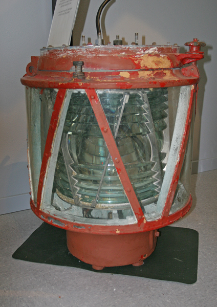
The Fresnel lens continued its countless revolutions until it was removed in 1995 and replaced with a modern beacon. The two keepers dwellings are no longer standing. The only remaining companions to the lighthouse are two oil houses and the fog signal building, which has been remodeled to serve as temporary housing for maintenance crews.
The Fresnel lens is now on display at the Westport Maritime Museum, where it is promoted as the finest first-order lens display in the world. While it is a mighty lofty claim, it just might be true. A seventy-foot Lens Building, constructed in 1998, houses the lens, and a ramp partially encircles the display, permitting views at various levels. A skylight above the lens lets natural sunlight dance on the prisms, while the lens slowly rotates, casting its twenty-four spotlights around the room. A backup lens that was formerly mounted atop Destruction Island Lighthouse is also on display.
In April 2008, the Coast Guard, citing that the beacon was no longer being used for navigation, switched off Destruction Island Lighthouse for good. Now with no need for upkeep, the remote lighthouse will surely soon start showing signs of neglect.
Keepers:
References


