Marrowstone Point, WA 
Select a photograph to view a photo gallery

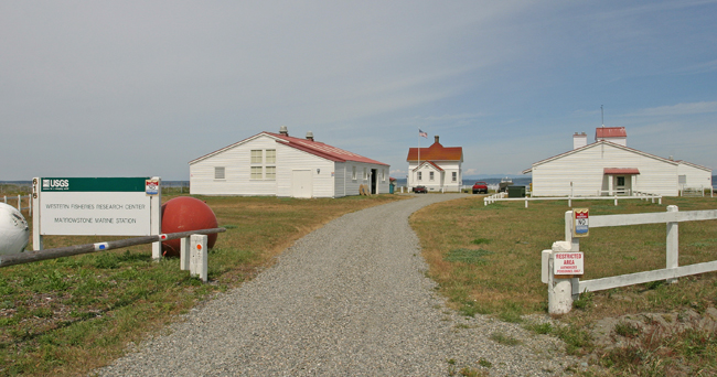

Photo Gallery
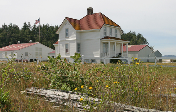

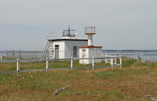


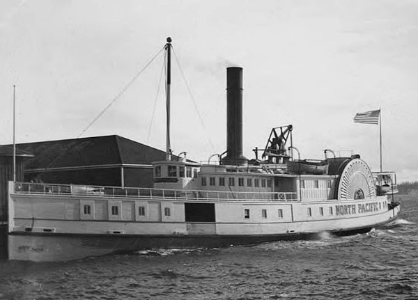


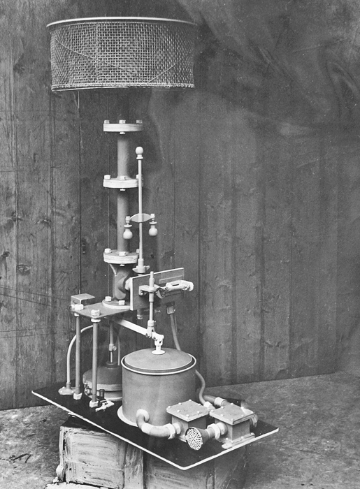
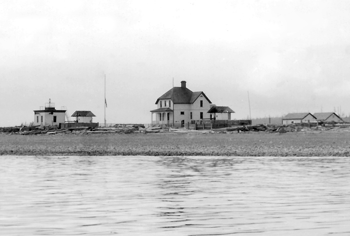


Photo Gallery
Photo Gallery
In most of my excursions I met with an indurated clay, much resembling fullers-earth. The high steep cliff, forming the point of land we were now upon, seemed to be principally composed of this matter; which, on a more close examination, appeared to be a rich species of the marrow stone, from whence it obtained the name of Marrow-stone Point.
|
Marrowstone Point forms the eastern entrance to Port Townsend Bay and was first marked by a lens lantern on a pole on October 1, 1888, around the time when several such aids were established on Puget Sound. To supplement this red light, the Lighthouse Board made the following recommendation in 1892:
A large fog bell here would be of great service to the commerce of these waters. It would mark the sharp turn in the course entering or leaving Puget Sound. In case appropriation is made to replace the bell now at Point No Point with a first-class fog signal, the bell taken from there can be established at Marrowstone Point. It is estimated that the bell can be set up and that the necessary buildings for the accommodation of the keeper can be erected for $3,500.
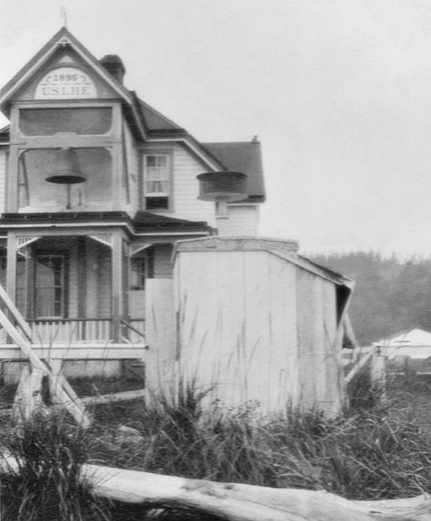
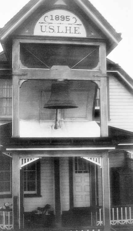
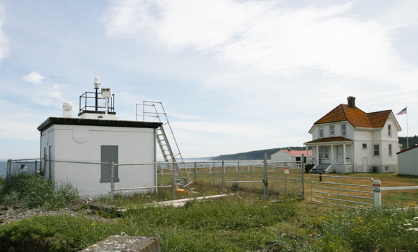
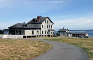
Congress appropriated the requested amount on March 3, 1893, but it would take two years before the needed land was obtained and plans and specifications for the structures were prepared. The contractors finished a one-and-a-half-story, six-room keepers dwelling with an attached fog-bell tower in March 1896, and the fog bell was placed into operation on April 7, 1896. During periods of fog or low visibility, the 1,200-pound bell was struck a double blow every fifteen seconds by a hammer operated by a Gamewell striking apparatus.
The following Notice to Mariners was published to advertise the stations imminent completion:
The Lighthouse Board gives notice that on or about April 7 a fog bell will be established at Marrowstone Point post light station, the northeast extremity of Marrowstone Island, Admiralty Inlet, Washington. During thick or foggy weather, the bell will be struck by machinery a double blow every fifteen seconds. The bell will be suspended sixteen feet above the ground, in front of the keepers dwelling, recently erected. The dwelling is a one and one-half story wooden structure, painted white, with lead colored trimmings and red roof.In 1902, the bells characteristic was changed to a single blow every fifteen seconds.
The first keeper at Marrowstone Point was Osmore H. Morgan, a seventy-year-old former sea captain, who had spent the prior fourteen years as head keeper of New Dungeness Lighthouse. Keeper Morgan served until his passing in 1907, when Nettie E. Race, his daughter who had been taking care of her widowed father, was briefly placed in charge of the light and bell. Axel Rustad was appointed keeper a few months later, and he and his wife, Karen, raised four sons on the point over the next decade. Water for the stations inhabitants consisted of rainfall that was stored in a 5,000-gallon, redwood tank, enclosed in a shed behind the dwelling.
|
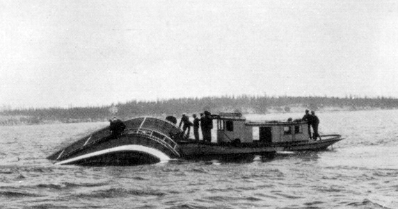
The fog bell wasnt successful in keeping all ships safely away from Marrowstone Island. In July 1903, the side-wheel steamer North Pacific, with just fourteen passengers on board, struck Craven Rock off Marrowstone Point in a dense fog. The steamer began to leak badly, and all passengers were safely transported ashore by the steamers lifeboats and the tug C.B. Smith that responded to the steamers distress signals. Keeper Morgan provided food and shelter to the passengers and crew from the North Pacific until they were taken aboard the steamer Mainlander which had ran aground on Marrowstone Point the same morning but was able to back off at high tide. The North Pacific sank in deep water and was a total loss.
Shortly after the first keeper took up residence at the station, construction of Fort Flagler commenced on the bluff above. The fort was completed in 1907, and it became the third active fort guarding Admiralty Inlet. Together with the guns at Fort Casey on Admiralty Head and those at Fort Worden near Point Wilson, the batteries at Fort Flagler helped form a Triangle of Fire to prevent hostile vessels from entering Puget Sound.
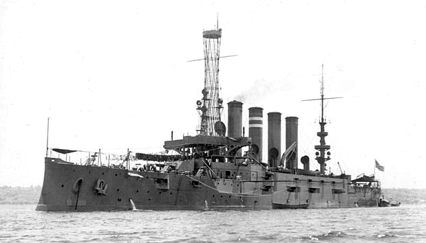
On August 15, 1908, the 502-foot-long armored cruiser USS Colorado ran aground on Liplip Point, the southeast tip of Marrowstone Island. This incident focused attention on the paucity of aids to navigation in Puget Sound, and as a result Congress appropriated $30,000 on October 22, 1913 for new navigation aids and improvements to existing ones.
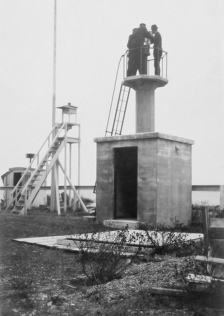
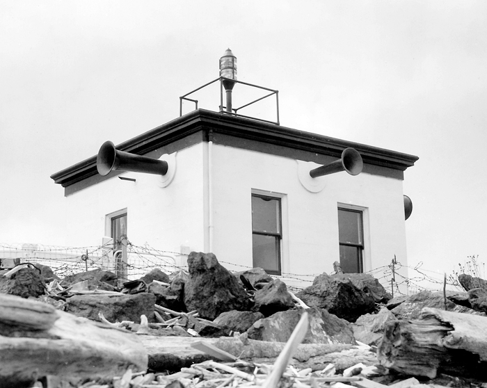
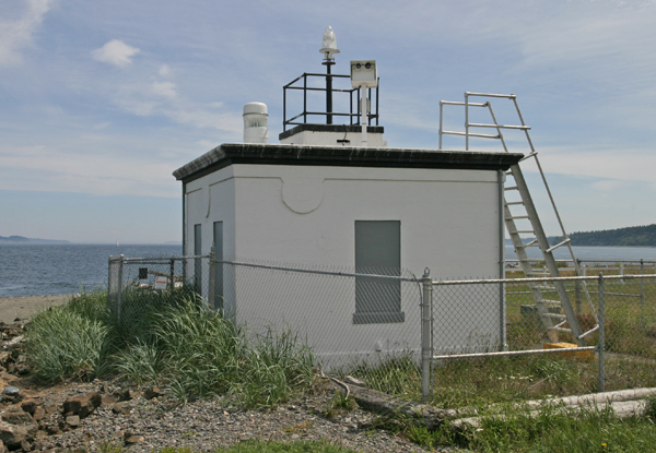
In 1914, Marrowstone Point received a new fog signal and light. On April 1, 1914, an experimental acetylene gun, housed in a small wooden structure thirteen yards northeast of the bell tower, took the place of the fog bell. The gun was detonated every thirty seconds, and mariners were requested to report the efficiency of the acetylene gun as a fog-signal to the lighthouse inspector in Portland. Two months later, on June 5, 1914, a new acetylene light was established atop a concrete structure. At this time, the lights characteristic was changed from fixed red to a two quick red flashes every six seconds.
The acetylene fog-gun at Marrowstone Point, of the type manufactured by William Moyes & Son of Glasgow, Scotland, was the first of its kind to be used in the United States. A gas regulator diaphragm, floating in a bath of oil, was slowly raised, under the pressure of acetylene gas supplied by storage tanks, until it released a trigger that fired the vapor in a discharge chamber. After each firing, the diaphragm sank, only to be raised again thirty seconds later by the pressure of accumulating gas.
|
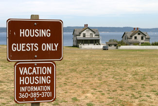
Though automated in 1962, the station remains fairly intact. The property was transferred in 1972 from the Coast Guard to the Bureau of Sport Fisheries and Wildlife in the U.S. Fish and Wildlife Service, for use as a scientific research facility. The keepers dwelling serves as a guest house for scientists visiting the Marrowstone Marine Field Station, and the 1917 short, squat structure that housed the light and fog signal still stands at the waters edge along with the 1914 light tower. A flashing white light is exhibited from atop the 1917 structure, but a fog signal is no longer in use. Research in marine ecosystem health and marine fish health is conducted at the station.
Fort Flagler is now Fort Flagler State Park and includes a military museum.
Keepers:
References
