Port Colborne Outer, ON 
Select a photograph to view a photo gallery
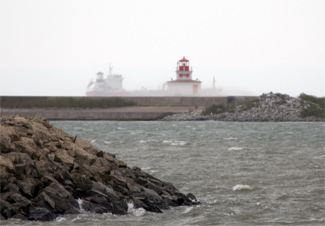
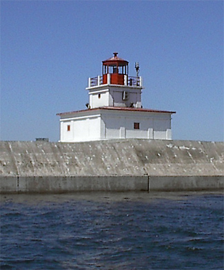
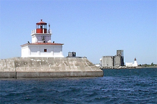
Photo Gallery


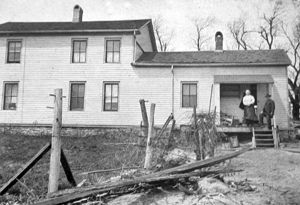
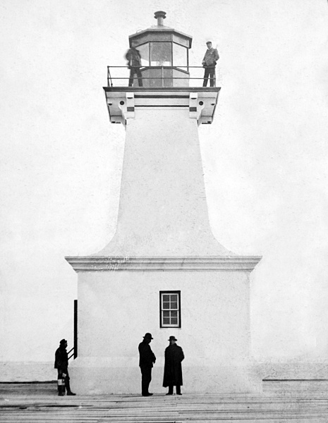

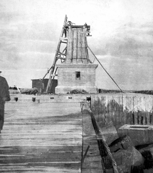
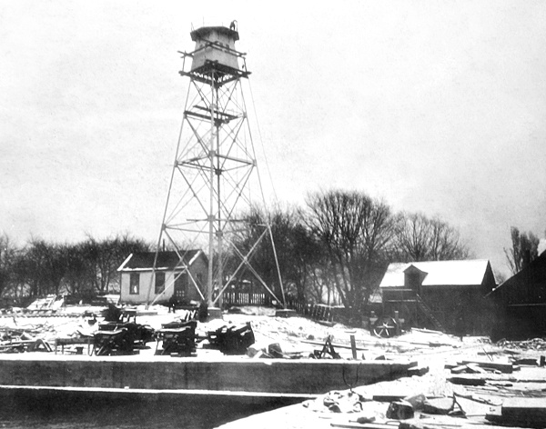


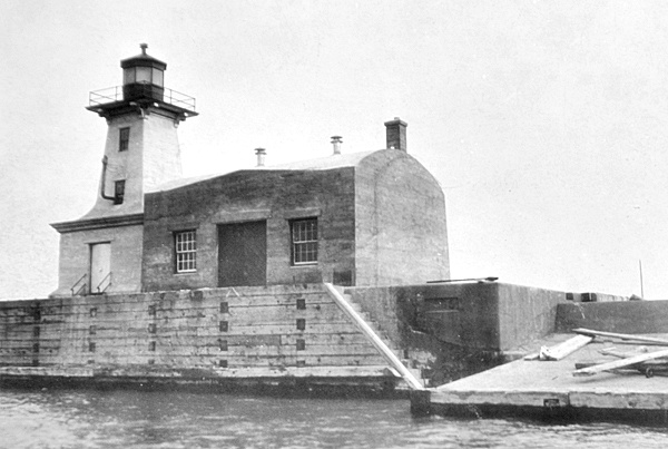
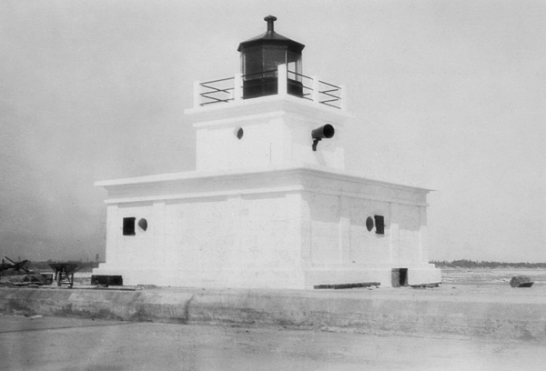
Photo Gallery
Photo Gallery
|
Parallel piers were constructed at Port Colborne to protect the entrance to the canal, and Edward Cochrane was hired in 1834 to mind the lighthouse built at the outer end of the eastern pier. A gale in early 1837 caused extensive damage to the piers and lighthouse, necessitating £2,188 in repairs.
While the southern portion of the canal was being enlarged between 1845 and 1850, the feeder canal that ran to Port Maitland served as the Lake Erie terminus for the Welland Canal. A set of range lights was established at Port Colborne in 1850 to guide mariners into the improved harbour there.
James Fortier, a veteran of the War of 1812, was the first keeper of the range lights, and in 1854, he wrote a letter requesting an increase in his salary so he could support his family. After detailing how he was severely wounded in the Head by a Rifle ball [and] was taken prisoner and remained so 12 months, Fortier made the following plea:
My Salary as Light House Keeper is so small that I cannot support my family with Common necessaries of life on so small an income, and further beg leave to say, that my former services as well as my present services entitles me from Government, that I have so faithfully served all my young days, a sufficient Salary to live on, and my present situation is attended Spring & Fall, at times at the risk of my life.
Four years earlier, Keeper Fortier had written to the Chief Commissioner of Public Works asking for either a keepers dwelling or a housing allowance, as he knew most other keepers were provided a residence while he had to pay rent out of his comparatively small salary. This keepers dwelling was eventually built on shore, but not until after Fortiers service.
The following description of the range lights at Port Colborne was provided by the Superintendent of Lights above Montreal in 1876:
The main light is a fixed white catoptric, containing ten dual-burner fountain lamps on three iron frames. There are six 15-inch, two 16, one 18 and one 20-inch reflectors. The lantern is of iron, has an iron floor, and is eight feet in diameter The glass is 18 x 14 1/2 inches. The tower is 44 feet high, and is a white circular wooden building. The range light contains one base-burner, and one 15-inch reflector. As has already been reported, these two lighthouses are perfectly rotten, and although I have given orders to have the range light temporarily repaired by being propped up, they will barely last through this fall. On a windy day the keeper scarcely dares go up into them to light them.
|
The main and front Light situated on the West Head Pier at the western entrance to the Welland Canal, was put in operation on the 15th May last, and is a fixed white catoptric light, elevated 70 feet above water mark, and should be seen 16 miles from all points on the lake. The Tower is an open-framed square wooden building, 60 feet high, and is painted white. The Back Range Light is placed on the pier on the east side of the entrance, 1,130 feet from the main Light. It is a fixed red catoptric light, elevated 38 feet above water mark, and should be seen eight miles. The Tower is a square wooden building standing upon a block, and painted white; it is 27 feet high from base to vane. The two lights in range give the deepest water to the entrance of the canal and clear the Sugar Loaf Reef. One of the improved Champion Fog-Trumpets has been erected at the main Light, and sounds a blast of eleven seconds in each minute and a half during thick weather. As will be seen by reference to Appendix No. 8, the sum of $ 1,013.31 has been expended on these Lighthouses and Fog-Horns during the past fiscal year, making, with previous expenditure, the total cost to amount to $7,219.31.
After the Welland Canal was deepened, the alignment of the range lights had to be altered as in their former position they led over a bar that had less water over it than was found in the canal. Thus, in 1887, the inner range light was relocated to a new cribwork block at the inner angle of the east breakwater pier. After this move, the range lights were 2,030 feet apart.
A storm on January 9, 1889, damaged the base of the main light and washed away most of the elevated wooden walkway that allowed the keeper to access the tower in stormy weather. Messrs. Dickinson and Seuss were awarded a $1,385 contract to build a new wrought-iron walkway, and the main light tower was rebuilt by William H. Noble, foreman of works for the Department of Marine, at a cost of $4,761.09.
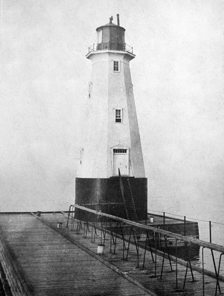
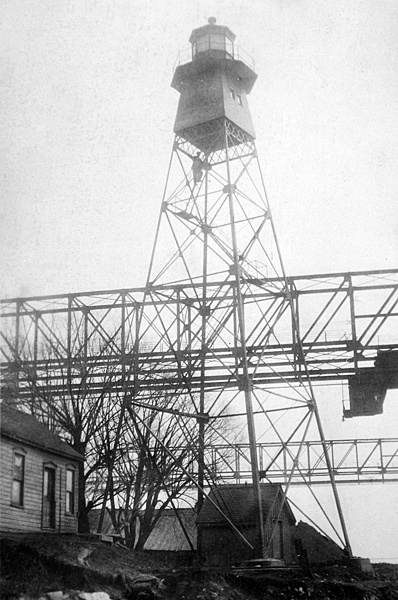
A cylindrical concrete base, twenty-five feet in diameter, twenty-two-feet tall, and encased in 5/16 steel plate, was built to serve as a foundation for an enclosed wooden octagonal tower that was surmounted by the old towers lantern room. The new tower, which went into service on August 1, 1890, stood sixty feet tall and exhibited a fixed light at a height of seventy feet. The foghorn machinery, which was formerly housed in a lean-to adjacent to the old tower, was placed in the base of the new tower. The cylindrical base of the tower was painted brown, the octagonal tower white, and the iron lantern red.
In October 1901, the inner range tower was relocated to the west side of the harbour, where it was 2,090 feet from the outer range on the west pierhead. This new range lead into the harbour 110 feet clear of the new large breakwater, which was being constructed at the time by the Public Works Department to form an artificial harbour. By arrangements with Public Works, a concrete block, 100-feet long, sixty feet wide, and thirteen feet above the lake, was built at the end of the breakwater to serve as the foundation for a new lighthouse. The Department of Marine published the following description of this new lighthouse, which is known today as the Port Colborne Inner Light:
|
A lighthouse has been erected on the outer end of the new breakwater at the entrance to Port Colborne, and the light put in operation on the 17th October, 1903. This light replaces the temporary lights, shown from lens lanterns, referred to in last years report which have been discontinued and the mast removed.The new concrete lighthouse served as a front light to the main light situated on the end of the west pier. As part of harbour improvements, the main light was taken down in 1906 and replaced by three electric arc lights established on the Grand Trunk Railways elevator, which stood on the east bank of the Welland Canal. The lights were spaced three feet apart and had focal planes of seventy-eight, eighty-one, and eighty-four feet. The three lights were 5,540 feet from the west breakwater light and had the same alignment previously marked by the breakwater and main lights.The tower is of concrete, square in plan, the sides of the lower portion being vertical and those of the upper portion sloping, and the whole painted white. It is surmounted by an octagonal iron lantern painted red. The tower is 46 feet high from its base to the top of the ventilator on the lantern.
The light is a fixed red light, elevated 50 feet above the level of the lake, and should be visible 8 miles from all points of approach by water. The illuminating apparatus is dioptric of the seventh order. A stronger and more distinctive light will be substituted later.
A diaphone has been installed in the base of the lighthouse, which will be put in operation on the opening of navigation in 1904.
The tower was erected under contract by Messrs. Hogan and MacDonell, contractors for the breakwater, and cost $6,200.00; the fog alarm machinery, supplied by the Canadian Fog Signal Company cost $2,400.
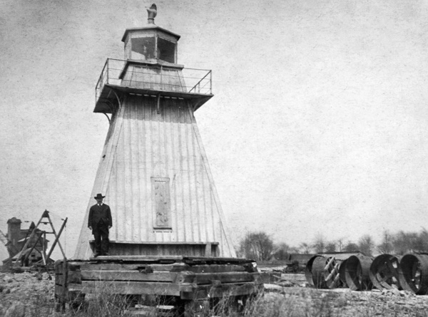
At the opening of navigation in 1908, a ninety-seven-foot-tall steel skeletal tower replaced the lights on the railways elevator. The metal tower was supplied by Messrs. Gould, Shapley & Muir, of Brantford, Ontario, for $1,657.80, and the concrete foundations for the tower were built by days labour at a cost of $270. In 1914, the rear range lighthouse was moved eighty-five feet east to the eastern side of Fares Street as it was interfering with port operations along the canal.
On November 1, 1907, the fog alarm inside the breakwater lighthouse was replaced by a more powerful fog alarm installed in a new rectangular concrete building with an arched roof that was erected on the west side of the lighthouse. This new diaphone was operated by air compressed by an oil engine and gave a two-and-a-half-second blast every minute. M.J. Hogan of Port Colborne erected the fog alarm building under contract for $4,900.
|
In 1928, a new concrete lighthouse at the southeast end of the new west breakwater extension or spur was placed in operation. This square structure, built of reinforced concrete and known as the Port Colborne Outer Light, is surmounted by a red iron lantern and together with the 1903 breakwater lighthouse marked the entrance to the harbour and the Welland Canal. The air diaphone was placed inside the outer lighthouse, and an electrically operated fog bell was placed on the gallery of the inner lighthouse and rung continuously during thick or foggy weather. A tunnel was built inside the breakwater spur to help the keepers reach the outer lighthouse during storms.
A radiobeacon was established at Port Colborne in 1942, and a new two-storey frame dwelling was built next to the old concrete fog alarm building near the inner light to provide space for the extra personnel needed to operate the radiobeacon. The radiobeacons signature was the letter Z (--..), repeated three times, followed by three dashes.
Al Kendrick served as the operator of the radiobeacon from 1943 to 1946, and then after a year break in which he married, he returned to the station as head keeper and radiobeacon operator in 1947. Keeper Kendrick spent the next thirty-two years at the lighthouse, before retiring in 1979. In September 1976, Kendrick rescued two couples from Hamburg, New York after their twenty-six-foot sailboat crashed into the breakwater and began to break up in five-foot waves. By attaching a rope thrown to them by Keeper Kendrick to the sailboat, the four occupants were able to make their way onto the breakwater. A pilot boat was summoned to pick up the two couples and transport them to shore where they were treated at the local hospital for minor cuts and bruises.
In 2013, Friends of Port Colborne Lighthouse started offering tours of the lighthouses during the citys annual Canal Days.
Head Keepers: Edward Cochrane (1834 - ), James Fortier (1849 1865), David Hugh A. Fortier (1865 1911), Hugh Clark, Jr. (1911 1915), Captain George Irwin (1915 1928), Jason Stewart Sherk (1928 1929), J. Sherk (1929 1936), Jason S. Sherk (1936 at least 1937), Al Kendrick (1947 1979), Jack Bonisteel (1979 1986).
References


