Port Weller, ON 
Select a photograph to view a photo gallery

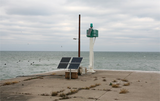

Photo Gallery
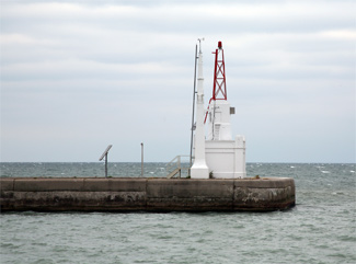

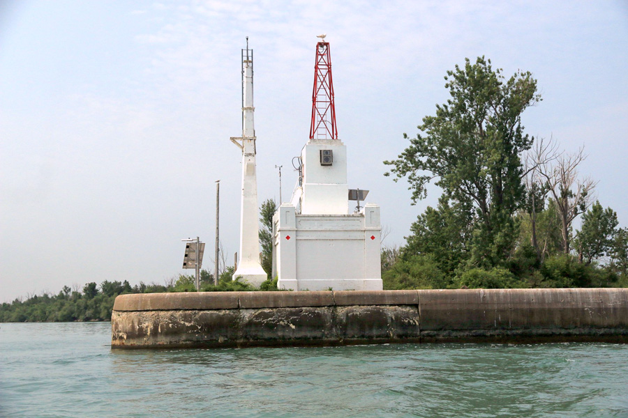
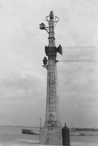
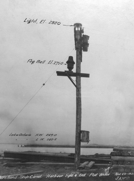

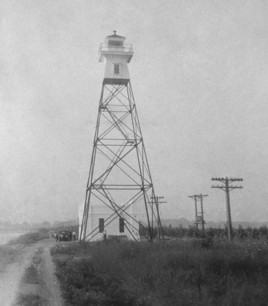
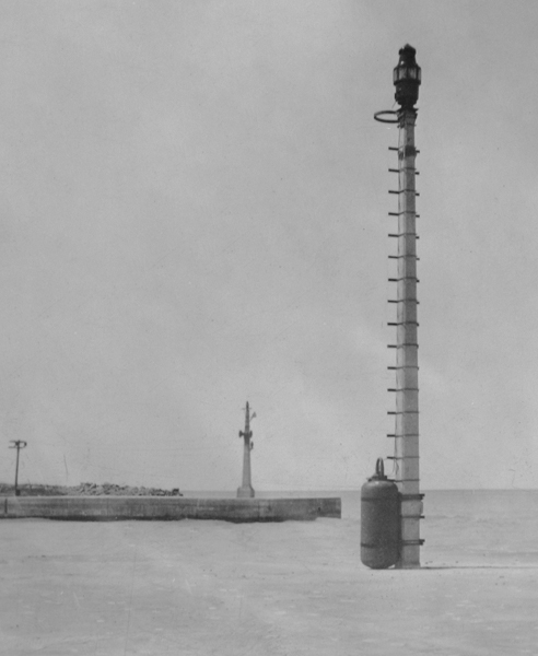
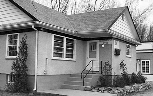
Photo Gallery
Photo Gallery
|
The third version of the canal was completed in 1887 and featured a shorter alignment between St. Catharines and Port Dalhousie. With this work, the number of locks was reduced by one, the length of the shortest lock was increased to 270 feet, and the canals depth was taken to fourteen feet.
The fourth and current version of the canal was built between 1913 and 1932 and saw a straightening of the northern portion of the canal with the northern terminus being moved from Port Dalhousie to Port Weller. In the present configuration, there are just eight locks, each of which is 766 feet long, and the depth is maintained at twenty-five feet.
To form an artificial harbour for the entrance to the canal at Port Weller, two pincer-shaped breakwaters were extended into Lake Ontario using material excavated during work on the fourth canal. In August 1921, a wooden pole was erected at the outer end of the west embankment at Port Weller, and on it were mounted a cluster of fixed white electric lights and an electrically-operated fog bell. A concrete mast replaced the wooden pole in 1925.
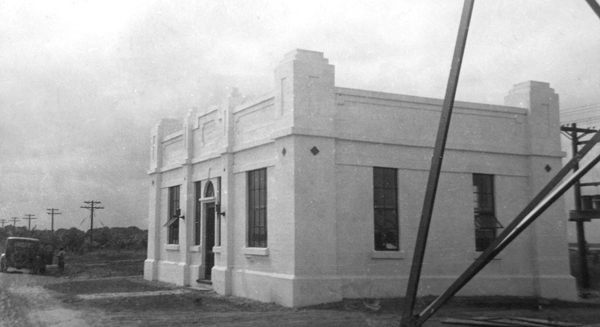
The pierhead light and bell served alone until 1931, when the fourth version of the Welland Canal was nearing completion and a combination keepers dwelling and generator building was built on the west bank of the canal at Port Weller along with a four-section, skeletal lighthouse. The following description of this work appeared in the Annual Report of the Lake Carriers Association for 1931:
A main light and fog signal established at the entrance to Welland Ship Canal is located on the west breakwater, 3,300 feet from its outer end. The structure is a steel skeleton tower surmounted by white square wooden watchroom and lantern, with white rectangular reinforced concrete dwelling and power house near base of tower. The light, elevation 95 feet, is flashing white electric, showing one flash every five seconds.The cluster of occulting white lights on concrete pole on the outer end of the west breakwater will continue to be shown and in addition, and from the same pole, there are two headlights, one throwing a beam of light toward the lake and the other focused on the outer end of the east breakwater.
The fog signal is an electric horn established on the light pole on the outer end of the west breakwater, sounding a blast of 2 seconds duration every 10 seconds, thus: Blast 2 seconds, silent 8 seconds.
After the erection of the tall metal tower, the concrete pierhead light, formerly known as the Port Weller Light, became the Port Weller Outer Light, while the skeletal tower was known as the Port Weller Main Light.
|
The first keeper of the Port Weller lights was William J. Gander, a veteran of the Great War who received the Colonial Auxiliary Forces Officers Decoration.
In 1934, an automatic radiobeacon was established at Port Weller as an additional aid for mariners, and in 1936, a seventh-order dioptric flashing green acetylene light was established on the outer end of the east embankment. Also in 1936, a sixth-order dioptric apparatus with an electric bulb replaced the cluster of lights exhibited from the top of the concrete mast at the end of the west embankment.
After having served in the Royal Canadian Air Force during the Second World War, Cyril Williamson was looking for secure employment to support his wife Ethel and their two sons. One evening in September 1945, Cy looked up from the evening paper and asked Ethel, How would you like to live in a lighthouse? A lighthouse? Why would I want to live in a lighthouse?, Ethel responded as she stopped her knitting and stared at him in amazement. You must be joking.
Cy wasnt joking, and after showing Ethel the ad for a lighthouse keeper, he explained that there would be a lot of competition for jobs now, and his experience with radios during the war would be a good fit for the position. Of the eight men who applied, Cy ranked first, and the family moved to the lighthouse in time to open it for the shipping season on April 1, 1946.
Cy and Ethel finished raising their two teenage sons at the lighthouse, and they both became licensed ham radio operators. Ethel was reportedly one of the first women in Canada to earn her license, and during her years at the lighthouse, she contacted people from over 250 countries. Following the war, many Canadian servicemen were still stationed overseas, and Ethel was often contacted to see if she could relay a message to their families.
Sometimes I wrote to the relatives making a date for them to come to the lighthouse at a certain time, Ethel noted. When this arrangement turned out satisfactory, and the wife or parents could come for the schedule, it was the most rewarding time of my life. Sometimes it was more than I could bear; hearing these conversations between loved ones, who were so many miles apart, I often felt like running from the room to hide my tears. I knew only too well the awful heartache of being separated from those we love.
When she wasnt talking on the radio or busy with her family, Ethel found time to knit over 1,500 wool hats that she donated to charity. Her years of service were recognized in 2002, when she was awarded a Queens Jubilee Medal. At the age of ninety-eight, she had the honour of christening the new Canadian Coast Guard vessel Cape Storm at the Port Weller Coast Guard Station, where she and Cy lived for twenty-five years. In 1972, Ethel published the book A Light on the Seaway, which chronicles her familys time taking care of the Port Weller Lights.
The present square concrete building topped by a metal tower that marks the western entrance to Port Weller was apparently erected in 1949, as it was that year that the focal plane of the light was raised from thirty-two to forty-five feet and a new fog signal was installed, producing two blasts a minute in this manner: three-second blast, nine seconds of silence, three-second blast, forty-fives seconds of silence. An L-shaped dwelling was built just south of the 1931 dwelling in 1953. The Wiliamsons moved into the new residence, and an assistant keeper was hired to live in the older one. Cy built a garage and breezeway between the two buildings, which was convenient as the watchroom was in the 1931 building and Cy had to thus travel between the two structures several times a day. The 1953 dwelling and the 1949 foghorn building were both declared Recognized Federal Heritage Buildings in 1989.
The Saint Lawrence Seaway Corporation established a set of range lights farther inland to safely guide mariners through the gap in the breakwater at Port Weller in 1969, and on June 23 of that year, Port Weller Main Lighthouse was discontinued. The tall skeletal tower remained standing for a year, and then a crane was brought in to lift the tower off its foundation and lay it on its side so it could be cut up and sold for scrap. When the crane tried to lift the tower after its hold-down bolts were cut, the crane and tower both toppled over in a terrifying crash. To expedite removal, the towers wooden portion was doused in petroleum and burned before the metal pieces were cut up with an acetylene torch.
Both the 1953 and 1931 residences now serve as the Port Weller Search and Rescue Station for the Canadian Coast Guard.
Keepers: William J. Gander (1931 1945), Cyril Williamson (1945 1969).
References


